Hingham Bay facts for kids
Quick facts for kids Hingham Bay |
|
|---|---|

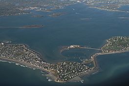
Aerial view looking southwest with the town of Hull in the foreground
|
|

|
|
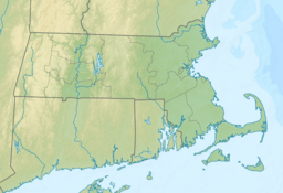
| Location | Massachusetts, United States |
| Coordinates | 42°17′N 70°55′W / 42.28°N 70.92°W |
| Type | Bay |
Hingham Bay is a pretty bay located in Massachusetts, United States. It's part of the larger Boston Harbor and Massachusetts Bay. This bay forms the western edge of the town of Hull and the northern edge of Hingham. It's also connected to the Weymouth Fore River, which touches Weymouth. Hingham Bay is special because it's home to several beautiful Boston Harbor Islands.
Contents
About Hingham Bay
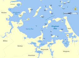
Hingham Bay is shaped almost like a square. It's about 3 miles (4.8 km) wide from east to west and 4 miles (6.4 km) long from south to north. It's almost completely surrounded by land. This land includes peninsulas (pieces of land almost surrounded by water), former islands that are now connected to the mainland, and a large island called Peddocks Island.
There are two main ways for boats to get in and out of Hingham Bay to the Atlantic Ocean. One is a narrow opening called Hull Gut, which is about 1,300 feet (400 meters) wide. It's located between Peddocks Island and Windmill Point. The other way is called West Gut, which is about 0.5 miles (0.8 km) wide. This passage is between Peddocks Island and Houghs Neck at Nut Island.
Along the western side of Hingham Bay, there's a special channel. It's about 300 feet (91 meters) wide and 35 feet (11 meters) deep. This channel allows large ships to travel from Hull Gut all the way to the Weymouth Fore River. The town of Hull borders the bay to the north and east. On the south side, Hingham Bay gets water from three rivers:
- The Weir River, between Hull and Hingham.
- The Weymouth Back River, between Hingham and Weymouth.
- The Weymouth Fore River, between Weymouth and Quincy.
Islands of Hingham Bay
Several islands are part of Hingham Bay. Some of them are also part of the Boston Harbor Islands National Recreation Area. These include:
- Bumpkin Island, which is about 30 acres (12 hectares).
- Grape Island, which is about 54 acres (22 hectares).
- Smaller islands like Slate Island and Sheep Island.
Spinnaker Island in the north is connected to Hull by a small bridge. Other smaller islands, less than 5 acres (2 hectares) in size, are found in Hingham Harbor. These include Button, Langlee, Ragged, and Sarah Islands. The southeastern part of the bay is separated from the Weir River by World's End. This is a beautiful park shaped like a peninsula, owned by The Trustees of Reservations.
History of Hingham Bay
The shape of Boston Harbor and Hingham Bay was created by something amazing: Quaternary glaciations. These were periods over the last 100,000 years when huge sheets of ice, called glaciers, covered the land. As the glaciers moved, they carved out the land, creating hills called drumlins and ridges called moraines. When the glaciers melted, the sea level rose and flooded the lower areas, forming the bays and islands we see today. This is why the harbor has so many interesting necks, peninsulas, and islands.
Early People and Settlers
Long ago, about 8,000 years ago, Native American tribes like the Massachusett lived on the islands of Hingham Bay. They used the bay's rich natural resources, like shellfish, fish, and wild plants, for food. In 1621, settlers from England arrived in the area. They were the first Europeans to meet the native people. Sadly, during King Philip's War in 1675, Native Americans were forced to leave the islands and the Hingham Bay area. After that, fishing continued to be a very important activity for the colonists.
Military and Industry
Hingham Bay has also played a role in military history.
- During the American Revolution, military posts were set up on Peddocks Island and Fort Revere. These spots were important because they guarded the Hull Gut entrance to Hingham Bay.
- In the early 1900s, ships and submarines were built at the Fore River Shipyard. This shipyard was located on the Weymouth Fore River, close to where it enters Hingham Bay.
- During World War II, hundreds of ships for the United States Navy were built at the Fore River Shipyard and the Bethlehem-Hingham Shipyard in Hingham. These ships all entered the Atlantic Ocean for the first time through Hingham Bay.
Protecting the Bay
After World War II, the unused land at World's End on Hingham Bay was considered as a possible location for the United Nations Headquarters. Later, it was also thought of as a place for a nuclear power plant, but that plant was eventually built in Plymouth.
Today, people are working hard to protect Hingham Bay. The Boston Harbor Islands National Recreation Area was created in 1996 to help protect the islands. Also, in 2002, the towns of Cohasset, Hingham, and Hull formed the Weir River Estuary Park Committee. These efforts help keep Hingham Bay a beautiful and healthy place for everyone.
 | Calvin Brent |
 | Walter T. Bailey |
 | Martha Cassell Thompson |
 | Alberta Jeannette Cassell |


