
Cohasset, Massachusetts facts for kids
Quick facts for kids
Cohasset, Massachusetts
|
|||
|---|---|---|---|

Cohasset Town Common
|
|||
|
|||

Location as an exclave of Norfolk County in Massachusetts
|
|||
| Country | United States | ||
| State | Massachusetts | ||
| County | Norfolk | ||
| Settled | 1647 | ||
| Incorporated | 1770 | ||
| Government | |||
| • Type | Open town meeting | ||
| Area | |||
| • Total | 31.44 sq mi (81.42 km2) | ||
| • Land | 9.79 sq mi (25.35 km2) | ||
| • Water | 21.64 sq mi (56.06 km2) | ||
| Elevation | 50 ft (15 m) | ||
| Population | |||
| • Total | 8,381 | ||
| • Density | 856/sq mi (330.6/km2) | ||
| Time zone | UTC−5 (Eastern) | ||
| • Summer (DST) | UTC−4 (Eastern) | ||
| ZIP Code |
02025
|
||
| Area code(s) | 339/781 | ||
| FIPS code | 25-14640 | ||
| GNIS feature ID | 0618317 | ||


Cohasset is a charming town located in Norfolk County, Massachusetts, in the United States. It's known for its beautiful coastline and rich history. In 2020, about 8,381 people called Cohasset home.
Contents
Exploring Cohasset's Past
Cohasset has a long and interesting history, starting with its first inhabitants.
Who Lived in Cohasset First?
Before European settlers arrived, the land that is now Cohasset was home to Native American tribes. The Pokanoket people lived here until 1649. After that, the Wampanoag and then the Massachusett tribes lived in the area.
How Did Cohasset Get Its Name?
The name "Cohasset" comes from the Massachusett language. The original word was "Conahasset." It likely means "long rocky place" or "fishing promontory." This makes sense because Cohasset has a very rocky coastline.
The first written record of the area was in 1614. Captain John Smith explored the New England coast. He wrote about meeting Native Americans in canoes at a place called Quonahasit.
When Was Cohasset Settled by Europeans?
English settlers first came to Cohasset around 1670. Much of the land was given to a group called the "Conahasset Partners." These partners were often large landowners from nearby Hingham.
The town was laid out in a unique way. Many lots were long and narrow. This allowed more homes to have road access.
Becoming Its Own Town
For a long time, Cohasset was part of Hingham. It was known as Hingham's Second Parish. But in 1770, Cohasset officially became its own separate town. This happened 100 years after the first English settlers arrived.
Cohasset was first part of Suffolk County. In 1793, a new county, Norfolk County, was created. Cohasset became part of Norfolk County. However, in 1803, Hingham and Hull joined Plymouth County. This left Cohasset as a unique part of Norfolk County, separated from the rest of it.
Where is Cohasset Located?
Cohasset is a coastal town with a mix of land and water.
Cohasset's Location and Neighbors
The town has a total area of about 81.4 square kilometers (31.4 square miles). Most of this area, about 68.86%, is water. Cohasset is located on the "corner" of the South Shore. This is where the greater Boston Harbor area ends and Massachusetts Bay begins.
Cohasset shares borders with several other towns:
- To the west: Hingham
- To the northwest: Hull
- To the east and south: Scituate
- To the north and northeast: Massachusetts Bay
It's about 12 miles (19 km) east of Braintree. It's also about 20 miles (32 km) southeast of Boston by road.
What is Cohasset's Landscape Like?
The coastline of Cohasset is very rocky. You'll see many small ledges and rocks just offshore. Cohasset Cove and The Gulf form part of the border with Scituate. Straits Pond separates Cohasset from Hull.
Near the center of the coast is Little Harbor. This is a large inlet that is separated from the ocean by Beach Island. Several small rivers and brooks flow through the town. A large part of the southwestern area is covered by Wompatuck State Park. There's also a bird sanctuary and a large park called Wheelwright Park near Little Harbor.
Cohasset has three beaches along the bay. It also has a yacht club, a sailing club, and a public boat launch in Cohasset Harbor.
What is the Weather Like in Cohasset?
Cohasset has a climate with hot, humid summers. Winters are generally mild to cool. It's known as a humid subtropical climate.
- Coldest Month: January, with average low temperatures around 20°F (–7°C) and highs around 37°F (3°C).
- Warmest Month: July, with average low temperatures around 62°F (17°C) and highs around 81°F (27°C).
- Snowiest Month: February, with an average of 14.2 inches (36 cm) of snow. The yearly average is about 48.3 inches (123 cm).
- Record Temperatures: The coldest ever recorded was –13°F (–25°C) in 1961. The hottest was 100°F (38°C) in 2002.
People and Families in Cohasset
Cohasset is home to many families. Here's a look at the town's population.
How Many People Live in Cohasset?
As of the 2020 census, there were 8,373 people living in Cohasset. There were 2,722 households and 2,024 families. The population density was about 770 people per square mile (330 per square kilometer).
What are Cohasset Households Like?
- About 39.9% of households had children under 18 living with them.
- Most households (64.0%) were married couples living together.
- About 22.7% of households were made up of individuals living alone.
- The average household size was 2.74 people.
- The average family size was 3.27 people.
What is the Age Range of Residents?
The median age in Cohasset was 43.6 years.
- 29.4% of the population was under 18 years old.
- 16.0% of the population was 65 years or older.
How Do People in Cohasset Earn a Living?
In 2013–2017, the estimated average yearly income for a household was $140,000. For families, it was $180,345. The average income per person was $75,885.
Most adults in Cohasset have a good education:
- 98.3% have at least a high school degree.
- 73.3% have a bachelor's degree or higher.
Learning in Cohasset
Cohasset has its own school system for students from pre-kindergarten through high school.
Cohasset Public Schools
The town's school department serves about 1,500 students.
- Osgood Elementary School: For students from pre-kindergarten to second grade.
- Deer Hill Elementary School: For students from grades 3 to 5. It's next to the Osgood School.
- Cohasset High School|Middle/High School: This school combines middle and high school grades. It's located a short distance from the other two schools.
School Sports and Activities
Cohasset's sports teams are called the Skippers. Their colors are navy blue and white. They compete in the South Shore League. Their main rival is Hull High School.
Students at Cohasset High School can join many athletic programs, including:
- Baseball
- Ice Hockey
- Basketball
- Cross Country
- Tennis
- Competitive Debate Team
- Football (The team won the 2014 Division VI Super Bowl!)
- Soccer
- Competitive Swimming
- Track and Field
- Sailing
- Ski Team
- Wrestling
- Lacrosse
Students can also choose to attend South Shore Vocational Technical High School in Hanover. This school offers technical and vocational training. There are no private schools in Cohasset itself, but there are some in nearby towns like Hingham.
Getting Around Cohasset
Cohasset has several ways to get around, though no major highways run through it.
Roads and Highways
The main state route through Cohasset is Route 3A. It connects Cohasset to Scituate and Hingham. Route 228 runs along the border with Hingham.
Airports and Public Transport
The closest small airport is Marshfield Municipal Airport. For bigger flights, people use Logan International Airport in Boston. T. F. Green Airport in Rhode Island is another option.
The MBTA bus system serves the nearby town of Hingham. Cohasset also has its own MBTA commuter rail station. This station is part of the Greenbush Line and is located off Route 3A.
Cohasset in Movies
Cohasset's beautiful scenery has made it a popular spot for filming movies!
Here are some movies that were filmed in Cohasset:
- The Witches of Eastwick (1987)
- HouseSitter (1992)
- The Finest Hours (2016)
- Thoroughbreds (2017)
- Confess, Fletch (2022)
Images for kids
-
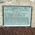
A historic marker on the European discovery of Cohasset
-
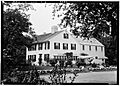
Cushing–Nichols House, Cohasset
-
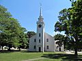
First Parish Meeting House, a Unitarian Universalist congregation originally built c. 1750.


See also
 In Spanish: Cohasset (Massachusetts) para niños
