White, Georgia facts for kids
Quick facts for kids
White, Georgia
|
||
|---|---|---|

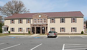
White City Hall
|
||
|
||
| Motto(s):
“The Friendliest Mile in Georgia”
|
||

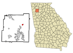
Location in Bartow County and the state of Georgia
|
||
| Country | United States | |
| State | Georgia | |
| County | Bartow | |
| Area | ||
| • Total | 1.05 sq mi (2.71 km2) | |
| • Land | 1.05 sq mi (2.71 km2) | |
| • Water | 0.00 sq mi (0.00 km2) | |
| Elevation | 860 ft (262 m) | |
| Population
(2020)
|
||
| • Total | 661 | |
| • Density | 631.33/sq mi (243.87/km2) | |
| Time zone | UTC-5 (Eastern (EST)) | |
| • Summer (DST) | UTC-4 (EDT) | |
| ZIP code |
30184
|
|
| Area code(s) | 770/678/470/943 | |
| FIPS code | 13-82468 | |
| GNIS feature ID | 0356633 | |
White is a small city in Bartow County, Georgia, United States. In 2020, about 661 people lived there.
White is located along U.S. Highway 411. It is about 3 miles (5 km) north of Interstate 75. The city is a nearby community to Cartersville. Cartersville is about 9 miles (14 km) south of White. These two places are connected by homes and shops.
History of White, Georgia
A post office opened in White in 1890. The city got its name from James Alexander White. He was the first person to run the post office.
The Georgia General Assembly officially made White a town in 1919. This means it became a recognized city with its own local government.
In June 2022, Perry Bell became the new mayor of White. Sadly, he passed away a few months later in September 2022.
Where is White, Georgia?
White is located at coordinates 34°16′50″N 84°44′48″W.
The United States Census Bureau says the city covers about 1.05 square miles (2.71 square kilometers). All of this area is land.
People Living in White
| Historical population | |||
|---|---|---|---|
| Census | Pop. | %± | |
| 1920 | 319 | — | |
| 1930 | 544 | 70.5% | |
| 1940 | 474 | −12.9% | |
| 1950 | 454 | −4.2% | |
| 1960 | 439 | −3.3% | |
| 1970 | 462 | 5.2% | |
| 1980 | 501 | 8.4% | |
| 1990 | 542 | 8.2% | |
| 2000 | 693 | 27.9% | |
| 2010 | 670 | −3.3% | |
| 2020 | 661 | −1.3% | |
| U.S. Decennial Census | |||
In 2000, there were 693 people living in White. These people lived in 258 households, and 197 of these were families. The city had about 765 people per square mile (295 per square kilometer). There were 274 homes, with about 302 homes per square mile (117 per square kilometer).
Most people in the city were White (94.81%). A smaller number were African American (2.89%). Other groups included Native American, Asian, and people of two or more races. About 2.60% of the population was Hispanic or Latino.
About 41.1% of households had children under 18 living with them. More than half (56.6%) were married couples. About 14.3% of households had a female head without a husband. About 20.9% of households were single individuals. About 9.3% of these were people aged 65 or older living alone. The average household had 2.69 people, and the average family had 3.04 people.
The population's age was spread out. About 31.0% were under 18 years old. About 8.9% were between 18 and 24. About 28.7% were between 25 and 44. About 19.2% were between 45 and 64. Finally, 12.1% were 65 years or older. The average age was 32 years. For every 100 females, there were about 98 males.
The average income for a household in the city was $31,458. For families, the average income was $36,250. Men earned about $30,500, while women earned about $22,404. The average income per person in the city was $14,665. Some families and people had lower incomes.
See also
 In Spanish: White (Georgia) para niños
 | Sharif Bey |
 | Hale Woodruff |
 | Richmond Barthé |
 | Purvis Young |


