
Whitehorse Mountain (Washington) facts for kids
Quick facts for kids Whitehorse Mountain |
|
|---|---|

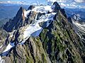
NW face from the Mount Higgins Trail
|
|
| Highest point | |
| Elevation | 6,840+ ft (2,080+ m) NGVD 29 |
| Prominence | 2,160 ft (660 m) |
| Geography | |
| Location | Boulder River Wilderness, Snohomish County, Washington, U.S. |
| Parent range | North Cascades |
| Topo map | USGS Whitehorse Mountain |
| Climbing | |
| First ascent | 1909 by Nels Bruseth |
| Easiest route | Northwest Shoulder (hike/snow climb/scramble) |
Whitehorse Mountain is a tall mountain located in the North Cascades mountain range in Washington state, USA. It stands near the town of Darrington, close to the edge of the Boulder River Wilderness area. Even though it's not the highest mountain in the North Cascades, it's famous for how steeply its sides rise. For example, its north side climbs 6,000 feet (about 1,830 meters) in less than 2 miles (3 kilometers)! This makes it look very impressive.
Contents
About Whitehorse Mountain
Whitehorse Mountain is part of the Mount Baker-Snoqualmie National Forest. It's a popular spot for adventurers who love to explore the outdoors. The mountain's steep slopes and beautiful views make it a special place in Washington.
Climbing the Mountain
The first person to climb Whitehorse Mountain was Nels Bruseth in 1909. Today, the most common way to reach the top is by following a path called the Northwest Shoulder.
- The Journey: This route starts with a challenging hike on a trail.
- Snow and Scrambling: As you go higher, you'll need to climb over snow. Near the very top, there's some "scrambling," which means you'll use both your hands and feet to climb over rocks. This part can be a bit tricky because it's very open and exposed.
- Hard Work: Climbing Whitehorse Mountain means gaining about 6,000 feet (1,830 meters) in height from the bottom to the top. This makes it a very tough and tiring trip, but the views from the summit are amazing!
Besides the Northwest Shoulder, there are other ways to climb Whitehorse Mountain. These include routes on the Whitehorse Glacier (on the north side) and along the East and Southeast Ridges.
How Whitehorse Mountain Got Its Name
Before it was called Whitehorse Mountain, local Coast Salish tribes had their own name for it in the Lushootseed language. They called it "So-bahli-ahli," which means "a lofty lady from the east."
The name "Whitehorse Mountain" was given in 1894 by W. C. Hiles, who was the postmaster in Darrington. He noticed a patch of snow on the mountain that looked just like a white horse. At the time, the townspeople were looking for a white horse owned by a pioneer named Fred Olds, and the snow patch reminded them of it.
Images for kids
-
The Whitehorse Glacier on the north side of the mountain.

