Whitwarta, South Australia facts for kids
Quick facts for kids WhitwartaSouth Australia |
|||||||||||||||
|---|---|---|---|---|---|---|---|---|---|---|---|---|---|---|---|

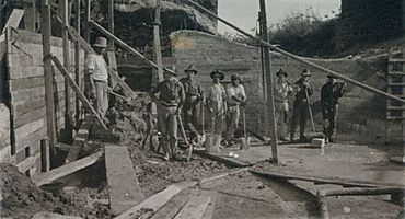
Construction of the Whitwarta Bridge (c. 1914) The bridge was officially opened on 17 August 1914. As reported in the Advertiser, The Commissioner of Crown Lands (Hon. F. W. Young) opened the bridge.
|
|||||||||||||||
| Established | 1870s | ||||||||||||||
| Postcode(s) | 5461 | ||||||||||||||
| LGA(s) | Wakefield Regional Council | ||||||||||||||
| State electorate(s) | Goyder | ||||||||||||||
| Federal Division(s) | Grey | ||||||||||||||
|
|||||||||||||||
Whitwarta is a small town in South Australia. It is located next to the Wakefield River, which local Indigenous people call Undalya. The town is about 100 kilometers north of Adelaide, the state capital.
The name Whitwarta comes from an older word meaning "freshwater". This is because there are freshwater springs nearby. These springs made Whitwarta a good place for a village, as the river often dries up elsewhere. Today, about 20 people live in the village.
Whitwarta is on flat plains. It sits between the Clare Valley and Skilly Hills to the east, and the Southern Hummocks Ranges to the west. You can also find several salt lakes in the countryside around Whitwarta.
The old Whitwarta School, built in 1879, is still standing. It is at the northern end of the village on Bowman St. The Post Office is at the southern end. The church and the Whitwarta Hotel were damaged by floods in the 1900s and were later taken down.
The Wakefield River used to flow every winter until the late 1970s. Now, because of dams upstream, it only flows about once every five years. This has caused the trees around Whitwarta to suffer from salty soil. The National Trust of South Australia has listed a group of special River Box trees (Eucalyptus largiflorens) in Whitwarta. These trees are unique to the area and grew after a flood many years ago.
You can find a gliding club and a rifle club just outside Whitwarta. The town also used to have its own cricket team and a tennis club.
Contents
Discovering Whitwarta's First People
The Kaurna people, specifically a group called the Nantuwaru, lived in the area around Whitwarta. They were about 25 to 30 people. Their land stretched from the Wakefield River north to Whitwarta and west to the Hummock Range.
In the 1960s, stone tools believed to be from the Nantuwaru people were found near the Wakefield River. These tools are now part of a collection at the South Australian Museum.
Major Floods in Whitwarta
The Wakefield River at Whitwarta has flooded several times. Here are some of the biggest floods:
- 2010: Heavy rains caused major flooding in early September. Water flowed across the roads and into fields around the town. No damage to homes or animals was reported.
- 1998: The river banks overflowed in winter. Water covered the roads and farmlands for several months. More rain in early summer caused another flood. The old Whitwarta Hotel ruins were underwater. Locals even caught fish in the water that stayed in a low area behind the town.
- 1937: A newspaper reported a wide "torrent of water" sweeping across the Whitwarta Road.
Whitwarta's Past: People and Stories
Whitwarta has a rich history with many interesting people and events.
Early Jobs and Businesses
In 1881, these jobs and businesses were recorded in Whitwarta:
- Storekeeper: R.T. Wilson
- Hotel: The 'Whitwarta' Hotel, run by David Pink
- Wheelwright: M. Koefner (a wheelwright makes and repairs wheels)
Whitwarta School Teachers
Many teachers worked at the Whitwarta School from 1879 to 1947. They helped educate the children of the area for many years.
Whitwarta and World War I
On Arbor Day in 1918, a special ceremony was held at the school. A "roll of honor" was revealed. This list remembered ten former students who served in the armed forces during World War I. Sadly, three of them were killed. One was Driver Eric R. Lange, who died in France. Another was Private Stanley Roy Angel, who returned home after the war.
Celebrating Whitwarta's Pioneers
On December 3, 2001, local residents gathered to celebrate the pioneers of Whitwarta. These were the people who first settled and developed the town and its farms. Many descendants of these pioneers were there. A special plaque was revealed to remember the occasion.
The plaque lists some of the early businesses and buildings in Whitwarta:
- Whitwarta Hotel (1886–1923)
- Telephone service added in 1924
- Wesleyan Church (1888–1920)
- Government Wells (1874–1912)
- Store and Post Office (1876–1967)
- Blacksmith (1878–1903)
- School (1879–1965)
It also names some important pioneers:
- J. J. Angel, farmer
- H. W. Clark, publican (hotel owner)
- J. R. F. Hoepner, blacksmith & wheelwright
- J. Hudson, teamster (someone who drives a team of animals)
- E. Router, farmer
- R. T. Wilson, storekeeper & clerk
- C. Belling, farmer
- W. J. Dunow, caretaker
- R. Hornhardt, storekeeper
- D. Pink, publican
- J. Watson, builder
A time capsule was buried under the plaque. It will be opened on December 2, 2101, by the people living in Whitwarta at that time.
Whitwarta Cemetery
The cemetery is about 1.5 kilometers east of the town. It is surrounded by Aleppo Pine trees. Two people buried there, John William Adams and Susanna Adams, were passengers on the ship HMS Buffalo. They arrived with the first Governor of South Australia in 1836 and were present when the colony was officially started.
The Whitwarta Bridge
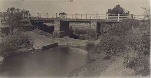
An early bridge over the Wakefield River was built around 1884. However, by 1912, it was falling apart due to white ants and rot. It was also too narrow for the vehicles using it.
A new bridge was opened on August 14, 1914. The Commissioner of Crown Lands, F. W. Young, officially opened it. Other important people, including members of parliament and the chairman of the local council, were also there.
Exploring Diamond Lake
Diamond Lake is about 3 kilometers west of Whitwarta Village. It is a unique feature of the area. This lake is an "ephemeral salt lake," meaning it is a salt lake that only fills with water sometimes. You can see its location on Google Maps.
The first Europeans to find Diamond Lake were explorers John Hill and Thomas Burr in 1840. They called it a "dry lagoon." When the lake fills after winter rains, you can see many types of wild birds there. These include Black Swans, Grey Teal, and Plovers. Gypsum, a mineral, is still dug from the banks of the lake.
 | Ernest Everett Just |
 | Mary Jackson |
 | Emmett Chappelle |
 | Marie Maynard Daly |


