Nantawarra, South Australia facts for kids
Quick facts for kids NantawarraSouth Australia |
|||||||||||||||
|---|---|---|---|---|---|---|---|---|---|---|---|---|---|---|---|

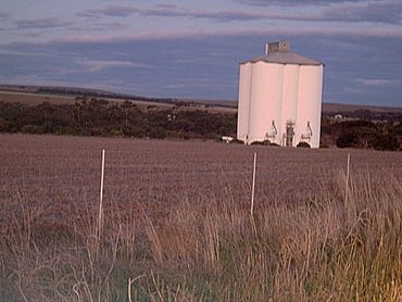
View of Nantawarra's silos from Highway 1, facing east
|
|||||||||||||||
| Postcode(s) | 5550 | ||||||||||||||
| Location |
|
||||||||||||||
| LGA(s) | Wakefield Regional Council | ||||||||||||||
| State electorate(s) | Narungga | ||||||||||||||
| Federal Division(s) | Grey | ||||||||||||||
|
|||||||||||||||
Nantawarra is a small place in South Australia. It is about 120 kilometers north of the city of Adelaide. This area is part of the Wakefield Regional Council.
You can find Nantawarra along Highway 1. It sits between Port Wakefield to the south and Snowtown to the north. A big landmark in Nantawarra is its old grain silos. These silos are just east of the railway line and can be seen from far away.
The name Nantawarra might come from the word nantuwara. This word is from the Kaurna language. It means a northern yerta, or family group, of the Kaurna people. The Kaurna people are the original Indigenous people of this part of South Australia.
In June 2023, there were plans to knock down the old grain silos. This news made many people in the local community upset.
First People of Nantawarra
Long ago, the land around Nantawarra was home to the Kaurna people. A specific group of Kaurna people, called the Nantuwara, lived here. They were a northern group of the Kaurna nation.
Their traditional land stretched from the Wakefield River north to Whitwarta. It also went west to the Hummock Range. This area includes places like Bowmans, Whitwarta, Goyder, Beaufort, Nantawarra, and Mount Templeton.
In the 1960s, special stone tools were found near the Wakefield River. These tools are believed to have been used by the Nantuwara people. They were added to the collection at the South Australian Museum. This collection was looked after by a person named Harold More Cooper.
 | Aurelia Browder |
 | Nannie Helen Burroughs |
 | Michelle Alexander |


