
Lochiel, South Australia facts for kids
Quick facts for kids LochielSouth Australia |
|||||||||||||||
|---|---|---|---|---|---|---|---|---|---|---|---|---|---|---|---|

The town entrance sign at Lochiel, depicting the seasonal pink colouration of Lake Bumbunga, the nearby hills, and horses pulling a salt scrape; the low wall in front depicts the "Loch Eel"
|
|||||||||||||||

Lochiel
Location in South Australia
|
|||||||||||||||
| Population | 362 (2011 census) | ||||||||||||||
| Postcode(s) | 5510 | ||||||||||||||
| Location | 125 km (78 mi) north of Adelaide | ||||||||||||||
| LGA(s) | Wakefield Regional Council | ||||||||||||||
| State electorate(s) | Narungga | ||||||||||||||
| Federal Division(s) | Grey | ||||||||||||||
|
|||||||||||||||
Lochiel is a small town in the Mid North of South Australia. It is about 125 kilometers (78 miles) north of Adelaide. The town sits on the western edge of Lake Bumbunga. It is also at the eastern foot of the Hummocks Range. The Augusta Highway, which is part of Highway 1, runs between the town and the lake.
Contents
What's in a Name?
In 1869, the Governor of South Australia, Sir James Fergusson, named the town "Lochiel." This is a Scottish name. It refers to the main family line of the Chiefs of Clan Cameron. The town is located in an area called the Hundred of Cameron. This area was named after an early settler, Hugh Cameron.
A Look Back: Lochiel's History
The town of Lochiel was planned in 1869. This happened soon after the area, the Hundred of Cameron, was officially named. In 1887, Lochiel became part of the District Council of Port Wakefield. However, residents wanted to be closer to Snowtown. So, in 1888, Lochiel joined the District Council of Snowtown. This created a strong link between Lochiel and Snowtown.
In 1976, a person living near Lochiel started a small, unofficial "country." It was called the Province of Bumbunga. This "country" no longer exists since 1999.
In 2011, a count of people showed that Lochiel and nearby farms had 362 residents.
How Lochiel is Governed
Today, the local government for Lochiel is the Wakefield Regional Council. This change happened in 1997. Before that, it was part of the District Council of Blyth-Snowtown. The town's official borders were set in the year 2000.
For state elections, Lochiel is in the Narungga area. For national elections, it is in the Grey area.
Lochiel's Economy
Salt Mining at Lake Bumbunga
People realized in 1868 that Lake Bumbunga was good for mining natural salt. Since 1881, salt has been collected from the lake bed in summer. This has provided jobs and helped the local economy for many years.
After 1913, the Australian Salt Company started working here. This company and others after it, like Cheetham Salt, have continued to harvest salt. Transporting salt became easier after a 9-kilometer (5.6-mile) railway line was built. This line connected the salt works directly to Port Adelaide. Lochiel's survival in the 20th century depended mostly on this salt industry.
Brown Coal Deposit
In 2011, a large amount of brown coal (lignite) was found north of Lochiel. It was estimated to be about 270 million tonnes. This coal was found in seven layers, 70 to 110 meters underground. The layers were between 0.3 and 3.0 meters thick. This site was good because it was only 6 kilometers (4 miles) from a railway line. This line connects to Adelaide, Darwin, and Perth. However, this coal deposit was never developed.
A Fun Attraction: The Loch Eel
In 1972, a local man named Gary Taylor and his friends made a sculpture. They used rubber tires and plastic. They placed it in the shallow waters of Lake Bumbunga, about 2.4 kilometers (1.5 miles) north of the town. They wanted it to be seen from the main highway. They called it "Loch Eel." This was a funny way to refer to the Loch Ness Monster.
There is talk that by early to mid-2022, Lochiel might get another new tourist attraction. This would give people another reason to stop and enjoy the area while driving on Highway 1.
Images for kids
-
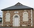
Lochiel's community hall
-
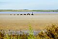
The "Loch Eel" sculpture in the shallows of Lake Bumbunga


