Kulpara, South Australia facts for kids
Quick facts for kids KulparaSouth Australia |
|||||||||||||||
|---|---|---|---|---|---|---|---|---|---|---|---|---|---|---|---|

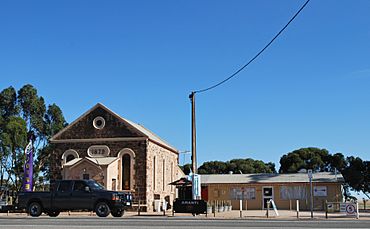
Cafe in the former church buildings at Kulpara
|
|||||||||||||||
| Established | 1864 | ||||||||||||||
| Postcode(s) | 5552 | ||||||||||||||
| Elevation | 117 m (384 ft) | ||||||||||||||
| Location |
|
||||||||||||||
| LGA(s) | District Council of Barunga West | ||||||||||||||
| State electorate(s) | Goyder | ||||||||||||||
| Federal Division(s) | Grey | ||||||||||||||
|
|||||||||||||||
Kulpara is a small country town in South Australia. It is located on the Copper Coast Highway and Upper Yorke Road. You can find it in the Hummocks Range, which is at the northern end of the Yorke Peninsula.
Contents
A Look at Kulpara's History
The name Kulpara comes from an Aboriginal word, Kula. This word means "eucalyptus," which is a type of tree.
Early Settlement and Growth
The Kulpara area was officially marked out in 1862. People started settling there soon after, around 1864. The town itself was planned in 1932 and officially named in 1934.
A community hall was built in 1902. Later, in 1953, it was replaced by a new hall. This new hall was built to remember soldiers. The local school opened its doors in 1877 and was made bigger in 1957. A church was also built in 1879. Today, that old church building is used as a convenience store.
Local Government
From 1878 to 1932, Kulpara was the main town for its local government area. This area was called the District Council of Kulpara.
Amazing Fossil Discovery
Near Kulpara, scientists found a very old fossil. This fossil is a type of stromatolite, which are layered rocks made by tiny living things called cyanobacteria. This special fossil was named Kulparia after the town where it was found.
 | Emma Amos |
 | Edward Mitchell Bannister |
 | Larry D. Alexander |
 | Ernie Barnes |


