
Kadina, South Australia facts for kids
Quick facts for kids KadinaSouth Australia |
|||||||||||||||
|---|---|---|---|---|---|---|---|---|---|---|---|---|---|---|---|

Kadina Town Hall
|
|||||||||||||||

Kadina
Location in South Australia
|
|||||||||||||||
| Established | 1861 | ||||||||||||||
| Postcode(s) | 5554 | ||||||||||||||
| Elevation | 44 m (144 ft) | ||||||||||||||
| Location | 144 km (89 mi) NNW of Adelaide | ||||||||||||||
| LGA(s) | Copper Coast | ||||||||||||||
| State electorate(s) | Narungga | ||||||||||||||
| Federal Division(s) | Grey | ||||||||||||||
|
|||||||||||||||
|
|||||||||||||||
Kadina (/kəˈdiːnə/ kə-DEE-nə) is a town in South Australia. It's located on the Yorke Peninsula, about 144 kilometres (90 miles) northwest of Adelaide, the state capital. Kadina is the biggest town on the Peninsula.
It's one of the three "Copper Triangle" towns. These towns are famous for their history of copper mining. They are also known as "Little Cornwall." This is because many people from Cornwall, England, came here to work in the mines in the late 1800s.
Today, the land around Kadina is very important for farming. Farmers here grow crops like wheat and barley. While Kadina used to be a mining town, farming is now the main activity.
Contents
About Kadina
Kadina is located about 20 kilometres (12 miles) northeast of Moonta. It's also 8 kilometres (5 miles) east of the port town of Wallaroo. The town of Kadina is made up of six smaller areas, or suburbs.
These areas each have their own history. They include Jericho, Jerusalem, Matta Flat, New Town, and Wallaroo Mines. The central part of Kadina is also one of these areas. Kadina East used to be a separate suburb, but it's now part of Kadina.
Kadina's History
First Peoples of Kadina
The Narungga people are the traditional owners of the land where Kadina is now. Their traditional lands cover the whole Yorke Peninsula. The name "Kadina" is believed to come from the Narungga word Kadiyinya. This word means 'Lizard Plain'.
European Settlement and Mining
Copper was found at Wallaroo Mines in 1859. Because of this discovery, land was surveyed in 1861. This land was set aside to build homes for the miners. This is how the "Government Town of Kadina" began.
A lot of copper was found in the years that followed. More copper was also found at nearby Matta Mine and Doora Mine. These copper mines attracted many skilled miners. A large number of these miners came from Cornwall, England.
In 1862, special areas called "Hundreds" were created. This allowed land to be sold near the copper mines. In the same year, a railway was built. It was pulled by horses and connected Kadina to the port at Wallaroo. This made it easier to transport copper. Later, more railway lines opened in 1878 and 1879. These connected Kadina to Port Wakefield and Bute.
Kadina became a municipality in 1872. This meant it had its own local government. By 1875, the town's population grew to 20,000 people. Most of these people were Cornish miners. In 1907, another area called "Kadina East" was surveyed. This helped house the growing number of people in the town.
Mining in Kadina completely stopped in 1938. The railway lines were no longer used and closed in 1989.
Historic Places in Kadina
Kadina has several places that are listed for their historical importance. These include:
- Drain Road: Kadina Cemetery
- 36-38 Taylor Street: Humphries Barber Shop
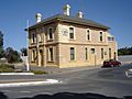
- 51 Taylor Street: Kadina Town Hall
Weather and Environment
Kadina has a semi-arid climate. This means it has hot, dry summers and cooler, wetter winters. The town is located above Goyder's Line. This is an imaginary line that shows where farming without irrigation becomes difficult. The area around Kadina has mallee scrub.
Kadina is about 8 kilometres (5 miles) inland from the coast. It is 44 metres (144 feet) above sea level. Temperatures change throughout the year. The average highest temperature in January is 30.5°C (87°F). In July, the average highest temperature is 15.5°C (60°F). The average lowest temperature in February is 15.8°C (60°F). In July, the average lowest temperature is 5.7°C (42°F).
Kadina doesn't get a lot of rain. The average yearly rainfall is about 388.6 millimetres (15.3 inches). There are about 92 days with rain each year. The town experiences about 122 clear days and 102 cloudy days annually. The hottest temperature ever recorded was 47.9°C (118.2°F) in January 2019. The coldest was -2.9°C (26.8°F) in August 2019.
| Climate data for Kadina (33º57'36"S, 137º42'00"E, 44 m AMSL) (1876-2005 normals, extremes 1957-2024) | |||||||||||||
|---|---|---|---|---|---|---|---|---|---|---|---|---|---|
| Month | Jan | Feb | Mar | Apr | May | Jun | Jul | Aug | Sep | Oct | Nov | Dec | Year |
| Record high °C (°F) | 47.9 (118.2) |
45.2 (113.4) |
41.6 (106.9) |
38.0 (100.4) |
30.5 (86.9) |
26.1 (79.0) |
24.2 (75.6) |
29.1 (84.4) |
35.0 (95.0) |
38.9 (102.0) |
44.6 (112.3) |
46.0 (114.8) |
47.9 (118.2) |
| Mean daily maximum °C (°F) | 30.5 (86.9) |
30.1 (86.2) |
27.4 (81.3) |
23.8 (74.8) |
19.3 (66.7) |
16.6 (61.9) |
15.5 (59.9) |
16.6 (61.9) |
19.5 (67.1) |
22.8 (73.0) |
25.8 (78.4) |
27.7 (81.9) |
23.0 (73.3) |
| Mean daily minimum °C (°F) | 15.7 (60.3) |
15.8 (60.4) |
13.8 (56.8) |
11.3 (52.3) |
8.5 (47.3) |
7.1 (44.8) |
5.7 (42.3) |
6.0 (42.8) |
7.4 (45.3) |
9.4 (48.9) |
11.9 (53.4) |
13.8 (56.8) |
10.5 (50.9) |
| Record low °C (°F) | 6.7 (44.1) |
6.7 (44.1) |
3.6 (38.5) |
1.2 (34.2) |
−0.8 (30.6) |
−2.8 (27.0) |
−2.8 (27.0) |
−2.9 (26.8) |
−2.6 (27.3) |
−0.2 (31.6) |
1.3 (34.3) |
4.6 (40.3) |
−2.9 (26.8) |
| Average precipitation mm (inches) | 14.9 (0.59) |
18.2 (0.72) |
19.1 (0.75) |
32.5 (1.28) |
45.8 (1.80) |
51.8 (2.04) |
48.5 (1.91) |
45.3 (1.78) |
38.9 (1.53) |
33.2 (1.31) |
22.5 (0.89) |
17.8 (0.70) |
388.6 (15.30) |
| Average precipitation days (≥ 0.2 mm) | 3.2 | 2.9 | 3.8 | 6.5 | 10.0 | 12.1 | 13.1 | 12.6 | 10.0 | 8.1 | 5.6 | 4.4 | 92.3 |
| Average afternoon relative humidity (%) | 36 | 37 | 40 | 47 | 59 | 63 | 65 | 60 | 53 | 44 | 40 | 38 | 49 |
| Average dew point °C (°F) | 11.5 (52.7) |
11.7 (53.1) |
10.3 (50.5) |
9.9 (49.8) |
9.6 (49.3) |
8.3 (46.9) |
7.8 (46.0) |
7.5 (45.5) |
8.6 (47.5) |
7.7 (45.9) |
8.3 (46.9) |
10.1 (50.2) |
9.3 (48.7) |
| Source: Bureau of Meteorology (1876-2005 normals, extremes 1957-2024) | |||||||||||||
How Kadina is Governed
Kadina is part of the Copper Coast Council. This local government area was created in 1997. Before that, Kadina had its own local councils.
Kadina is also part of a larger government area. It is in the federal division of Grey. For state government, it is in the electoral district of Narungga.
Kadina's Economy
Mining History
Kadina was once mainly a copper mining town. The Wallaroo Mines were right next to the town. After the mines closed in the 1920s, farming became the most important industry.
Farming Today
The land around Kadina is used for growing large amounts of cereal crops. Farmers commonly grow barley and wheat. They also grow other crops like canola, chickpeas, and field peas. The barley and wheat from this area are considered to be some of the best in the world.
Tourism and Festivals
Today, Kadina has many interesting old buildings. These buildings are from the colonial and federation times. They are mostly found around Victoria Square. You can also visit the Farm Shed Museum & Tourism Centre. This museum tells the story of Kadina's heritage. You can also see what's left of the old Wallaroo Mines.
Every two years, in May, Kadina hosts the Kernewek Lowender festival. This is a Cornish festival that celebrates the town's Cornish history. It's also held in Moonta and Wallaroo. Kadina and the surrounding areas benefit from tourism. Many people visit the Copper Triangle region.
Getting Around Kadina
The Copper Coast Highway goes through Kadina. The town used to be a railway junction. This means different railway lines met here. However, these lines are no longer used for regular trains. The section of the railway from Wallaroo to Kadina was turned into a walking and cycling path in 2009.
There is also a small airport nearby called Kadina Airport. It is used by small private planes and for emergency services.
Media in Kadina
Kadina is home to a local radio station called Gulf FM. It broadcasts on 89.3 FM. The local newspaper, the Yorke Peninsula Country Times, is also based in Kadina.
Famous People from Kadina
Many notable people have connections to Kadina, including:
- Oliver Badman (1885–1977), a politician
- Richard Champion (born 1968), a former AFL footballer
- Lynton Crosby (born 1957), a political strategist
- Leslie Heath (1902–1957), a politician
- John Olsen (born 1945), a former Premier of South Australia and Senator
- Rex Pearson (1905–1961), a politician
- Steve Prestwich (1954–2011), a musician
- Cameron Sutcliffe (born 1992), an AFL Footballer
- Horace Wilson (1864–1923), a cricketer
Images for kids
-
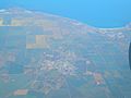
Aerial view of Kadina (centre, inland), looking west toward Spencer Gulf
-
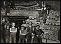
Miners, 1900
-
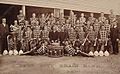
Copper City Brass Band, 1907
-
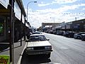
Shops in Graves Street, Kadina
-
Banking & Currency Museum
-
Introduced snails


