Wilson, New York facts for kids
Quick facts for kids
Wilson
|
|
|---|---|
| Town of Wilson | |

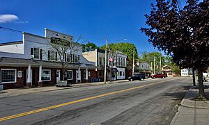
Young Street
|
|

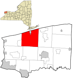
Location in Niagara County and the state of New York.
|
|
| Country | United States |
| State | New York |
| County | Niagara |
| Named for | Reuben Wilson |
| Government | |
| • Type | Town Council |
| Area | |
| • Total | 51.46 sq mi (133.29 km2) |
| • Land | 49.41 sq mi (127.96 km2) |
| • Water | 2.06 sq mi (5.33 km2) |
| Population
(2010)
|
|
| • Total | 5,993 |
| • Estimate
(2016)
|
5,841 |
| • Density | 118.23/sq mi (45.65/km2) |
| Time zone | Eastern (EST) |
| FIPS code | 36-063-82370 |
Wilson is a small town in Niagara County, New York, United States. In 2010, about 5,993 people lived there. The town is named after an early settler, Reuben Wilson. He built a log cabin by Lake Ontario, where the Village of Wilson is today.
The Town of Wilson is located on the northern edge of Niagara County. It includes a smaller area called the Village of Wilson.
Contents
History of Wilson Town
The Town of Wilson was created in 1818. It was formed from a part of the town of Porter. The town got its name from Reuben Wilson. He was one of the first people to settle in the area.
A historic building, the Morse Cobblestone Farmhouse, was added to the National Register of Historic Places in 2010. This means it's an important historical site.
Geography and Location
The Town of Wilson covers about 51.5 square miles (133.3 square kilometers). Most of this area is land, about 49.5 square miles (128.3 square kilometers). The rest, about 1.9 square miles (5.0 square kilometers), is water.
Wilson is located on the southern shore of Lake Ontario.
Roads and Highways
A main road, New York State Route 425 (also known as Wilson-Cambria Road), runs north and south. It crosses New York State Route 18 (Seaway Trail) in the Village of Wilson.
Neighboring Areas
The Town of Wilson shares borders with several other towns and a large lake:
- Town of Porter to the west
- Town of Lewiston to the southwest
- Town of Newfane to the east
- Town of Cambria to the south
- Lake Ontario to the north
Main Roads in Wilson
Here are the important roads that go through the Town of Wilson:
 New York State Route 18 (Lake Rd., Creek Rd.): This road goes east and west across the northern part of town. It runs close to Lake Ontario, from the Porter town line to the Newfane town line.
 New York State Route 93 (Youngstown-Lockport Rd.): This road also goes east and west. It runs through the southwest part of town, from the Cambria town line to the Porter town line.
 New York State Route 425 (Cambria-Wilson Rd., Lake Street): This road goes north and south through the town. It starts where it meets NY 18 and goes all the way to the Cambria town line.
Population Changes Over Time
| Historical population | |||
|---|---|---|---|
| Census | Pop. | %± | |
| 1820 | 688 | — | |
| 1830 | 913 | 32.7% | |
| 1840 | 1,753 | 92.0% | |
| 1850 | 2,955 | 68.6% | |
| 1860 | 3,372 | 14.1% | |
| 1870 | 2,912 | −13.6% | |
| 1880 | 3,234 | 11.1% | |
| 1890 | 2,978 | −7.9% | |
| 1900 | 2,881 | −3.3% | |
| 1910 | 2,970 | 3.1% | |
| 1920 | 2,753 | −7.3% | |
| 1930 | 2,801 | 1.7% | |
| 1940 | 3,061 | 9.3% | |
| 1950 | 3,696 | 20.7% | |
| 1960 | 5,319 | 43.9% | |
| 1970 | 5,316 | −0.1% | |
| 1980 | 5,792 | 9.0% | |
| 1990 | 5,761 | −0.5% | |
| 2000 | 5,840 | 1.4% | |
| 2010 | 5,993 | 2.6% | |
| 2016 (est.) | 5,841 | −2.5% | |
| U.S. Decennial Census | |||
In 2000, there were 5,840 people living in Wilson. These people lived in 2,224 homes. About 1,672 of these were families. The population density was about 118 people per square mile.
About 33.9% of homes had children under 18 living there. Most homes (62.4%) were married couples living together. The average home had 2.63 people, and the average family had 3.04 people.
The age of people in Wilson varied. About 25.7% of the population was under 18. About 13.5% of people were 65 years old or older. The average age in the town was 39 years.
Places Near Wilson
Here are some other places you can find near the Town of Wilson:
- Coolidge Beach – A small community along the shore, west of Roosevelt Beach.
- Dorwood Park – An area west of South Wilson.
- East Wilson – A community near the eastern town line on Chestnut Road.
- Elberta – A community in the western part of town, south of Wilson village.
- Hollands International Airport (85N) – A small airport with a grass runway. It's used for activities like parachute jumping.
- Hopkins Beach – A shoreline community near the western county line.
- Pleasant Corners – A community located on NY-425 at Braley Road.
- Roosevelt Beach – A shoreline community west of Wilson village.
- South Wilson – A community south of Wilson village on the Cambria-Wilson Road (NY-425).
- Sunset Beach – A shoreline community on the west side of Wilson village.
- Twelve Mile Creek – A stream that flows into Lake Ontario. It's located near the Wilson-Tuscarora State Park.
- Wilson – This is the Village of Wilson. It's on the Lake Ontario shore where routes NY-18 and NY-425 meet.
- Wilson-Tuscarora State Park – A park by the lake, west of Wilson village.
- Woodland Heights – A community by the lake near the northeast part of town.
See also
 In Spanish: Wilson (pueblo) para niños

