
Winfield Creek facts for kids
Quick facts for kids Winfield Creek |
|
|---|---|

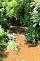
Winfield Creek looking upstream in Winfield
|
|
| Other name(s) | Dry Run |
| Physical characteristics | |
| Main source | valley on a ridge in Union Township, Union County, Pennsylvania between 700 and 720 feet (210 and 220 m) |
| River mouth | West Branch Susquehanna River in Union Township, Union County, Pennsylvania 430 ft (130 m) 40°54′46″N 76°51′01″W / 40.9129°N 76.8502°W |
| Length | 4.4 mi (7.1 km) |
| Basin features | |
| Progression | West Branch Susquehanna River → Susquehanna River → Chesapeake Bay |
| Basin size | 5.38 sq mi (13.9 km2) |
| Tributaries |
|
Winfield Creek is a small stream in Union County, Pennsylvania. It is also known as Dry Run. This creek flows into the West Branch Susquehanna River. Winfield Creek is about 4.4 miles (7.1 km) long. It flows through Union Township.
The area of land that drains into the creek, called its watershed, is about 5.38 square miles (13.9 km2). Winfield Creek is known as an "impaired" stream. This means its water quality is not as good as it should be. The main problems are changes to its natural environment and too much dirt and sand in the water. Even so, the creek is a good place for warmwater fish and fish that travel to different places, like migratory fish. However, it is not a trout stream.
Contents
Where Winfield Creek Flows

Winfield Creek starts in a valley on a ridge in Union Township. It flows southwest for a short distance. Then, it turns south and enters a wider valley.
The creek then flows south-southeast for a short way. It crosses under Pennsylvania Route 304. After that, it turns east-northeast. It flows in this direction for several miles, running next to Pennsylvania Route 304. The creek then enters the town of Winfield.
Eventually, Winfield Creek turns northeast and crosses under US Route 15. It then turns east. A short distance later, it joins the West Branch Susquehanna River. Winfield Creek is the last named stream that flows into the West Branch Susquehanna River before it reaches its end.
Streams Joining Winfield Creek
Winfield Creek does not have any named streams that flow into it. However, it does have four smaller, unnamed streams. Three of these streams join Winfield Creek from its right side. One stream joins it from its left side.
Water Quality of Winfield Creek
Winfield Creek is considered an impaired stream. This means its water quality is not ideal. The main reasons for this are changes to the creek's natural environment and too much sediment (like dirt and sand) in the water. These problems are likely caused by things like straightening the creek's path and farming activities nearby.
Land and Rocks Around the Creek
The land around the mouth, or end, of Winfield Creek is about 430 feet (130 m) above sea level. The area where the creek starts is higher, between 700 and 720 feet (210 and 220 m) above sea level.
Winfield Creek flows into the West Branch Susquehanna River from its right side. It is a very small stream. The creek flows through a valley made of limestone. This valley is narrow, with Shamokin Mountain to the north and higher lands to the south.
Winfield Creek's Watershed
The watershed of Winfield Creek covers an area of 5.38 square miles (13.9 km2). A watershed is all the land where water drains into a specific river or creek. The mouth of Winfield Creek is in the Northumberland area, according to the United States Geological Survey. However, its source is in the Lewisburg area.
History of Winfield Creek
Winfield Creek was officially added to the Geographic Names Information System on August 2, 1979. This system keeps track of names and locations of places in the United States. The creek's special identification number in this system is 1191593. It has also been known by the name Dry Run for a long time.
In 1774, a person named John Lee received land near Winfield Creek. Another person, John Aurandt, also owned land in the area a long time ago.
Two bridges cross Winfield Creek in Winfield. A concrete bridge carrying US Route 15 was built in 1930 and fixed in 1962. It is about 49.9 feet (15.2 m) long. Another concrete bridge, which carries State Route 2009, was built in 1991. It is about 29.9 feet (9.1 m) long.
Animals and Plants in the Creek
The area around Winfield Creek is a good place for warmwater fish. It is also a place for fish that migrate, meaning they travel to different areas at certain times of the year. However, Winfield Creek is not a place where trout live. One book about Pennsylvania streams said that Winfield Creek was "not worth further investigation" for trout fishing.
Images for kids
-
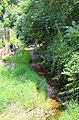
Winfield Creek looking upstream in Winfield
-
Winfield Creek looking downstream in Winfield
