
Winterhaven, California facts for kids
Quick facts for kids
Winterhaven
|
|
|---|---|

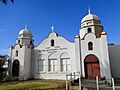
Fort Yuma United Methodist Indian Church
|
|

Location in Imperial County and the state of California
|
|

Winterhaven, California
Location in the United States
|
|
| Country | United States |
| State | California |
| County | Imperial |
| Area | |
| • Total | 0.238 sq mi (0.616 km2) |
| • Land | 0.238 sq mi (0.616 km2) |
| • Water | 0 sq mi (0 km2) 0% |
| Elevation | 131 ft (40 m) |
| Population
(2020)
|
|
| • Total | 390 |
| • Density | 1,639/sq mi (633/km2) |
| Time zone | UTC-8 (Pacific (PST)) |
| • Summer (DST) | UTC-7 (PDT) |
| ZIP code |
92283
|
| Area codes | 442/760 |
| FIPS code | 06-86020 |
| GNIS feature IDs | 1661702, 2409615 |
Winterhaven is a small community in Imperial County, California. It used to be called Karmack. Winterhaven is about 6.5 miles (10 km) east of Pilot Knob.
In 2010, about 394 people lived here. This was a bit less than the 529 people who lived there in 2000. Winterhaven is part of the larger El Centro metropolitan area.
The town is located north of Interstate 8 and right next to Yuma, Arizona. Part of Winterhaven is also on the Fort Yuma Indian Reservation. The Colorado River forms the southern edge of the town.
Contents
Communication Services
Winterhaven has its own telephone company, which is part of TDS Telecom. Phone numbers in the area start with (760) 572-xxxx. These numbers are used in Winterhaven and nearby communities like Bard and Felicity.
The communities of Bard and Felicity are very close to Winterhaven. Felicity and Winterhaven share the same ZIP code, which is 92283. Bard has a different ZIP code for its post office boxes: 92222.
Winterhaven had a post office for a few years starting in 1916. It then closed and reopened in 1934.
Geography and Climate
Winterhaven covers a total area of about 0.2 square miles (0.52 km2), and all of it is land. It is the community located furthest to the southeast in California.
Desert Climate
Winterhaven has a desert climate. This means it gets a lot of sunshine all year round. The weather is usually stable with high pressure. On climate maps, this type of weather is called "Bwh."
Population and People
Winterhaven in 2010
The 2010 census counted 394 people living in Winterhaven. Most people lived in homes, not in group housing.
- Racial Makeup:
- 62.2% White
- 9.4% Native American
- 21.3% from other races
- 66.2% of people were Hispanic or Latino.
There were 151 households in Winterhaven. About 39% of these households had children under 18. The average household had about 2.6 people.
The population was spread out by age:
- 29.4% were under 18 years old.
- 16.8% were 65 years or older.
The average age in Winterhaven was 39 years.
There were 186 housing units. About 41% of homes were owned by the people living in them, and 59% were rented.
Winterhaven in 2000
In the 2000 census, Winterhaven had 529 people. There were 183 households.
- Racial Makeup:
- 45.6% White
- 6.8% Native American
- 38.4% from other races
- 56.3% of people were Hispanic or Latino.
About 38% of households had children under 18. The average household had 2.9 people.
The median age was 31 years. The median income for a household was $11,563. Many families and people in Winterhaven lived below the poverty line.
Places to Visit
Nearby Communities
- Felicity, California
- Yuma, Arizona
- Los Algodones, Baja California
- Chocolate Mountains
Images for kids
-
Fort Yuma United Methodist Indian Church
See also
 In Spanish: Winterhaven para niños
