Winterscleugh facts for kids
Quick facts for kids Winterscleugh |
|
|---|---|

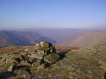
Summit cairn, looking north west up Borrowdale
|
|
| Highest point | |
| Elevation | 464.3 m (1,523 ft) |
| Prominence | 272 m (892 ft) |
| Parent peak | Tarn Crag |
| Listing | Fellranger |
| Geography | |
| OS grid | NY577028 |
| Topo map | OS Landranger 91 |
Winterscleugh is a hill in Cumbria, England. It stands about 464 meters (1,522 feet) tall. This hill is located just east of the famous Lake District area.
Since 2019, Winterscleugh has been part of the Lake District National Park. It sits between two main roads: the A6 road to its west and the M6 motorway to its east. You can find it on the northern side of the Borrowdale, Westmorland valley. This Borrowdale is different from the more famous one in the central Lake District.
What's in a Name?
The name Winterscleugh has an interesting meaning. It is thought to mean "the ravine connected to the Winter family." Records show that the Winter family owned land in the Borrowdale area back in the 1600s.
Exploring Winterscleugh
Winterscleugh is a great spot for a hike! You can include it in a longer walking adventure. One popular route is the "Whinash Ridge" walk. This walk is about 20 kilometers (12 miles) long.
It usually starts from the top of the A6 road, about 6 miles south of a town called Shap. Along the way, you'll cross other hills like Crookdale Crag and Whinash. The walk then finishes by returning along the bottom of the Borrowdale valley.
A New "Fellranger"
Winterscleugh is one of three hills that were recently added to a special list. This list is for hills called "Fellrangers." These are hills described in guidebooks by Mark Richards.
The other two hills added were Grayrigg Forest and Whinfell Beacon. These three hills joined the list between 2019 and 2021. This brought the total number of Fellrangers to 230. They were added because the Lake District National Park expanded its boundary in 2019. This expansion meant these hills were now inside the park for the first time.
 | Delilah Pierce |
 | Gordon Parks |
 | Augusta Savage |
 | Charles Ethan Porter |


