Wiscasset (CDP), Maine facts for kids
Quick facts for kids
Wiscasset, Maine
|
|
|---|---|

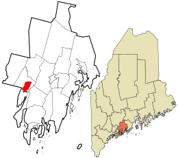
Location in Lincoln County and the state of Maine
|
|
| Country | United States |
| State | Maine |
| County | Lincoln |
| Town | Wiscasset |
| Area | |
| • Total | 3.93 sq mi (10.19 km2) |
| • Land | 3.90 sq mi (10.10 km2) |
| • Water | 0.04 sq mi (0.09 km2) |
| Elevation | 90 ft (30 m) |
| Population
(2020)
|
|
| • Total | 1,232 |
| • Density | 315.98/sq mi (122.00/km2) |
| Time zone | UTC-5 (Eastern (EST)) |
| • Summer (DST) | UTC-4 (EDT) |
| ZIP code |
04578
|
| Area code(s) | 207 |
| FIPS code | 23-87040 |
| GNIS feature ID | 0578612 |
Wiscasset is a special kind of community in Maine, United States. It's called a census-designated place (CDP). This means it's a specific area that the government counts for population, but it's not a separate city or town. Wiscasset is the main part of the larger town also named Wiscasset.
It is located in Lincoln County. In 2020, about 1,232 people lived in the Wiscasset CDP. The entire town of Wiscasset had 3,732 residents. Wiscasset is also the county seat of Lincoln County. This means it's where the main government offices for the county are located.
Contents
Where is Wiscasset Located?
The Wiscasset CDP is in the eastern-central part of the town of Wiscasset. It sits on the west side of the Sheepscot River. This river is affected by tides and forms the border with the town of Edgecomb to the east.
The CDP area stretches along the Sheepscot River. It goes south to Birch Point and north to a small bay. To the west, it reaches Ward Brook. The northern boundary is near Foye Road.
Major Roads and Travel
U.S. Route 1 is a very important road that goes right through the middle of Wiscasset. It's known as Main Street in the village. This highway crosses the Sheepscot River on the Donald E. Davey Bridge. This bridge connects Wiscasset to Edgecomb.
- US 1 goes northeast about 8 miles (13 km) to Damariscotta.
- It goes southwest about 10 miles (16 km) to Bath.
- Portland is about 44 miles (71 km) to the southwest.
Maine State Route 27 also comes into Wiscasset with US 1. However, it then turns north.
- ME 27 leads north about 17 miles (27 km) to Gardiner.
- It continues about 23 miles (37 km) to Augusta, which is Maine's state capital.
Another part of ME 27 splits off US 1 in Edgecomb. This part goes south to Boothbay Harbor, which is about 13 miles (21 km) from Wiscasset. Maine State Route 218 (Federal Street) also leaves Wiscasset. It goes northeast about 13 miles (21 km) to Whitefield.
Size of Wiscasset
The Wiscasset CDP covers a total area of about 3.93 square miles (10.2 square kilometers). Most of this area, about 3.90 square miles (10.1 square kilometers), is land. Only a small part, about 0.04 square miles (0.1 square kilometers), is water. Wiscasset High School is located within this area.
Who Lives in Wiscasset?
| Historical population | |||
|---|---|---|---|
| Census | Pop. | %± | |
| 2020 | 1,232 | — | |
| U.S. Decennial Census | |||
In 2020, the population of the Wiscasset CDP was 1,232 people. This number comes from the 2020 census.
Back in 2000, there were 1,203 people living here. There were 532 households, which are groups of people living together in one home. The population was spread out across different age groups:
- About 22.3% of the people were under 18 years old.
- About 19.3% were 65 years old or older.
The average age of people in Wiscasset in 2000 was 44 years.
See also
 In Spanish: Wiscasset (condado de Lincoln) para niños
 | Valerie Thomas |
 | Frederick McKinley Jones |
 | George Edward Alcorn Jr. |
 | Thomas Mensah |

