Witnesham facts for kids
Quick facts for kids Witnesham |
|
|---|---|
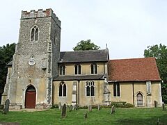
 Witnesham, Church of St Mary |
|
| Population | 792 (2011) |
| OS grid reference | TM1850 |
| Shire county | |
| Region | |
| Country | England |
| Sovereign state | United Kingdom |
| Post town | IPSWICH |
| Postcode district | IP6 |
| Dialling code | 01473 |
| EU Parliament | East of England |
Witnesham is a small village located about 4 miles (6.4 km) north of Ipswich in Suffolk, England. The main road connecting Witnesham to Ipswich is the B1077, also known as Westerfield Road. It's a quiet place with a mix of old history and modern village life.
Contents
Village History
Witnesham is mentioned in a very old book called the Domesday Book. This book was like a big survey of England made in 1086. In it, Witnesham was called 'Wytenesham', which probably meant "Witta's meadow" or "Witten's enclosure". At that time, it had 10 villagers. The village was part of an older area called Carlford, which was one of the traditional "Hundreds" of Suffolk. A Hundred was a historical way of dividing up land.
Witnesham Hall is an old building that was built way back in the 1500s. You can find it west of St Mary's church on Church Lane.
Life in Witnesham Today
In 2011, about 792 people lived in Witnesham. The village has some helpful places for its residents.
- Local Pub: The Barley Mow is a historic inn that has been around since 1766. It's a popular spot on Mow Hill.
- Primary School: There's a small primary school for younger students in the village.
- Post Office Services: While the old Post Office building has closed, you can still access postal services at the Baptist Church a couple of days a week.
The village has two churches. The Baptist Church is located at the northern end of the village on Upper Road. The larger church, St Mary's, is found west of Witnesham along Church Lane. This church is also close to where the River Fynn begins.
There are also several farms around Witnesham, like White House Farm to the east and Redhouse Farm to the south-east.
Getting Around Witnesham
Even though Witnesham is a village, it's easy to get to other places. Westerfield railway station is only about 2 miles (3.2 km) away. From there, you can catch trains to big cities like London Liverpool Street or other towns such as Lowestoft, Ipswich, and Felixstowe.
Local Activities and Businesses
One popular local spot is the Fynn Valley Golf Club, which is about a mile south of the village. It has two golf courses, a driving range where you can practice your swing, golf shops, and places to eat and hold events.
How Witnesham is Governed
Witnesham is part of an "electoral ward" which is an area used for local elections. This ward also includes the nearby village of Playford. In 2011, the total population of this electoral ward was 1,965 people. This means that when people vote for local representatives, they vote as part of this larger area.
Famous People from Witnesham
Several interesting people have connections to Witnesham:
- William King: He was a doctor who helped start the idea of co-operative movements, where people work together for shared benefit.
- Samuel Turner: He received the Victoria Cross, which is the highest award for bravery in the British military.
- Spencer John Bent: Another recipient of the Victoria Cross. He lived in Witnesham for several years as a child after his father passed away during the Boer War.
- Carl Giles: He was a famous cartoonist who created the well-known "Giles" cartoons for the Daily Express newspaper.
 | Emma Amos |
 | Edward Mitchell Bannister |
 | Larry D. Alexander |
 | Ernie Barnes |


