Wolseley, South Australia facts for kids
Quick facts for kids WolseleySouth Australia |
|||||||||||||||
|---|---|---|---|---|---|---|---|---|---|---|---|---|---|---|---|

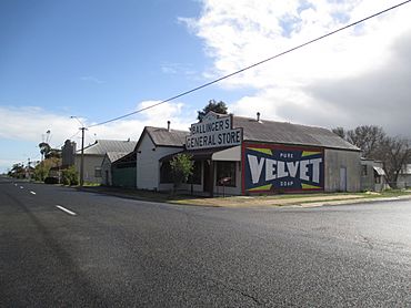
Wolseley historic shop with restored advertising sign on the side
|
|||||||||||||||
| Population | 180 (2016 census) | ||||||||||||||
| Established | 8 May 1884 (town) 16 March 2000 (locality) |
||||||||||||||
| Postcode(s) | 5269 | ||||||||||||||
| Elevation | 110 m (361 ft) | ||||||||||||||
| Time zone | ACST (UTC+9:30) | ||||||||||||||
| • Summer (DST) | ACST (UTC+10:30) | ||||||||||||||
| Location |
|
||||||||||||||
| LGA(s) | Tatiara District Council | ||||||||||||||
| Region | Limestone Coast | ||||||||||||||
| County | Buckingham | ||||||||||||||
| State electorate(s) | MacKillop | ||||||||||||||
| Federal Division(s) | Barker | ||||||||||||||
|
|||||||||||||||
|
|||||||||||||||
| Footnotes | Adjoining localities | ||||||||||||||
Wolseley (once called Tatiara) is a small town in South Australia. It is close to the border with Victoria. The town is about 5 kilometres (3 miles) south of the Dukes Highway. It is also 13 kilometres (8 miles) east of Bordertown. Wolseley was first officially made a town in 1884.
In August 2016, a count of the population found that 180 people lived in Wolseley.
Contents
Wolseley's Past: A Look at History
How Wolseley Got Its Name
The town was first planned in 1884. It was originally named Tatiara. This name came from an Aboriginal word. The word was used by the Jackegilbrab Tribe.
The railway station in the town was named after Lord Wolseley. He was a very important leader in the British Army. On 20 February 1941, the town's name was changed. It became Wolseley to match the railway station's name.
Wolseley's Role in World War II
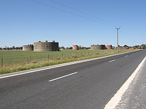
During the early years of World War II, a special fuel storage place was built in Wolseley. It was called RAAF No. 12 Inland Aircraft Fuel Depot. RAAF stands for Royal Australian Air Force.
This depot held a lot of fuel for airplanes. It had three large tanks. These tanks were cleverly hidden to look like farm buildings. The depot started working in 1942. Later, three more tanks were added. It stopped being used on 14 June 1944. Today, this old fuel depot is listed as a heritage site. This means it is an important historical place.
Trains and Railways in Wolseley
Connecting Cities by Rail
The Adelaide–Wolseley railway line opened in the early 1880s. It connected Adelaide to Wolseley. This line used a wide track, called broad gauge. Later, in 1886, a railway line from Melbourne reached Serviceton in Victoria.
The South Australian Railways then built the last three miles from Wolseley to Serviceton in 1887. This completed a broad gauge train link between Adelaide and Melbourne. Around the same time, a narrower train line, called narrow gauge, reached Wolseley. This line came from Mount Gambier. Wolseley became a place where different train track sizes met. This is called a break-of-gauge.
Solving the Break-of-Gauge Problem
Having different track sizes caused problems. Goods had to be moved from one train to another. This took a lot of time and effort. In 1936, to make things easier, special containers were introduced.
These containers allowed goods to be moved without being unloaded. The whole container could be lifted from a train on one track size to a train on another. This helped goods travel smoothly.
In the 1950s, the narrow gauge line to Mount Gambier was changed. It was made into a broad gauge line. This removed the break-of-gauge at Wolseley. The line to Mount Gambier has not been used since 1995. This was when the main Adelaide – Melbourne line was changed to a standard gauge. If the Mount Gambier line is ever changed to standard gauge, it would be the first line in Australia to have used all three track sizes.
How Wolseley is Governed
Wolseley is part of different government areas. These areas help manage the town and its people.
- Federal Government: Wolseley is in the federal division of Barker. This means people in Wolseley vote for a representative in the national parliament.
- State Government: For the state government, Wolseley is in the electoral district of MacKillop. This means people vote for a representative in the state parliament.
- Local Government: The local services for Wolseley are managed by the Tatiara District Council. This council looks after things like local roads and parks.
 | Misty Copeland |
 | Raven Wilkinson |
 | Debra Austin |
 | Aesha Ash |


