
Wolverton and Greenleys facts for kids
Quick facts for kids Wolverton and Greenleys |
|
|---|---|
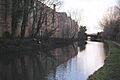
 Old Wolverton railway works with Stephenson bridge, adjoins and crosses the Grand Union Canal |
|

Wolverton and Greenleys
|
|
| Population | 12,492 |
| OS grid reference | SP821414 |
| Civil parish |
|
| Unitary authority |
|
| Ceremonial county | |
| Region | |
| Country | England |
| Sovereign state | United Kingdom |
| Post town | MILTON KEYNES |
| Postcode district | MK12 |
| Dialling code | 01908 |
| Police | Thames Valley |
| Fire | Buckinghamshire |
| Ambulance | South Central |
| EU Parliament | South East England |
| UK Parliament |
|
Wolverton and Greenleys is a town located in Milton Keynes, England. It's like a special local area with its own town council. This town is found north-west of Central Milton Keynes. In 2011, about 12,492 people lived here. The area includes places like Wolverton, Old Wolverton, Wolverton Mill, Greenleys, and Stonebridge.
Contents
Exploring Wolverton and Greenleys
This section helps you understand where Wolverton and Greenleys is located.
What are the Borders of the Town?
The town has clear boundaries. To the north, you'll find the River Great Ouse. The West Coast railway line forms the eastern border. To the south, the Millers Way (H2) grid road marks the edge. Finally, the A5 road is on the western side.
When Was the Parish Formed?
The area became a parish in 2001. This happened as part of a bigger plan to create local parishes across Milton Keynes. A parish is a local area with its own government, helping to manage local services.
Discover the Milton Keynes Museum
In the southeast part of Wolverton and Greenleys, you can visit the Milton Keynes Museum. This museum is a great place to learn about local history. It has a collection called the Stacey Hill collection, which shows what rural life was like long ago. You can also see many items from the nearby Wolverton railway works, which was a very important place for trains.
Images for kids
-
Old Wolverton railway works with Stephenson bridge, adjoins and crosses the Grand Union Canal
