
Woodville, Ohio facts for kids
Quick facts for kids
Woodville, Ohio
|
|
|---|---|
|
Village
|
|

Main Street runs concurrently with U.S. Route 20 and State Route 105 in downtown Woodville
|
|
| Motto(s):
"Lime Center of the World"
|
|

Location of Woodville, Ohio
|
|

Location of Woodville in Sandusky County
|
|
| Country | United States |
| State | Ohio |
| County | Sandusky |
| Township | Woodville |
| Area | |
| • Total | 1.35 sq mi (3.49 km2) |
| • Land | 1.35 sq mi (3.49 km2) |
| • Water | 0.00 sq mi (0.00 km2) |
| Elevation | 637 ft (194 m) |
| Population
(2020)
|
|
| • Total | 2,006 |
| • Density | 1,488.13/sq mi (574.75/km2) |
| Time zone | UTC-5 (Eastern (EST)) |
| • Summer (DST) | UTC-4 (EDT) |
| ZIP code |
43469
|
| Area code(s) | 419 |
| FIPS code | 39-86492 |
| GNIS feature ID | 2399739 |
| Website | http://villageofwoodville.com/ |
Woodville is a small town, called a village, located in Sandusky County, Ohio, in the United States. In 2020, about 2,006 people lived there. Woodville is special because the National Arbor Day Foundation has named it a Tree City USA, meaning it cares a lot about its trees!
Contents
History of Woodville, Ohio
Woodville was officially planned and mapped out in 1836. It got its name from a person named Amos E. Wood.
The Old Mud Pike: An Important Road
Woodville was once the middle point of a very important road called the Western Reserve and Maumee Turnpike. People also called it the "Old Mud Pike." This was because the road often became very muddy, making it hard for animals and wagons to travel.
This road was the first permanent path built across a difficult area known as the Black Swamp. It connected two towns: Perrysburg and Lower Sandusky (which is now called Fremont).

You can still see a special stone marker from this old road today. It is located at 100 East Main Street, right in front of the village pharmacy. Several of these milestones are still standing along the 31-mile stretch between Fremont and Perrysburg. Today, this historic route is known as U.S. Route 20.
Rivers and Railroads in Woodville
Woodville is also where U.S. Route 20 crosses the Portage River. Long ago, the former Pennsylvania Railroad also had tracks that crossed the Portage River in Woodville. This train line was once a main route connecting Toledo to Pittsburgh.
North of Woodville, there is a road called Woodville Road. It starts in Toledo, goes through Genoa, and ends in Elmore. However, this road does not actually pass through Woodville itself.
Trailmarker Park and Native American History
About half a mile upstream from the highway and train bridges, you will find Trailmarker Park. This spot is important because it was a shallow part of the river where Native Americans often crossed the Portage River.
There was once a tree that Native Americans had bent to mark this crossing point. It had a large branch that stretched over the west bank of the river, just south of the Cherry Street bridge. Sadly, village workers accidentally removed this important branch in the 1990s.
State Route 105 also runs through Woodville, connecting it to other areas.
Woodville's Geography and Location
Woodville is a village located in Ohio. According to the United States Census Bureau, the total area of the village is about 1.33 square miles (3.49 square kilometers). All of this area is land, with no large bodies of water inside the village limits.
Population and People of Woodville
| Historical population | |||
|---|---|---|---|
| Census | Pop. | %± | |
| 1880 | 406 | — | |
| 1900 | 831 | — | |
| 1910 | 807 | −2.9% | |
| 1920 | 910 | 12.8% | |
| 1930 | 1,151 | 26.5% | |
| 1940 | 1,219 | 5.9% | |
| 1950 | 1,358 | 11.4% | |
| 1960 | 1,700 | 25.2% | |
| 1970 | 1,834 | 7.9% | |
| 1980 | 2,050 | 11.8% | |
| 1990 | 1,953 | −4.7% | |
| 2000 | 1,977 | 1.2% | |
| 2010 | 2,135 | 8.0% | |
| 2020 | 2,006 | −6.0% | |
| U.S. Decennial Census | |||
Woodville's Population in 2010
Based on the census from 2010, there were 2,135 people living in Woodville. These people lived in 850 households, and 581 of those were families. The village had about 1,605 people per square mile. There were 894 homes in total.
Most of the people in Woodville were White (96.3%). A small number were African American (0.3%), Native American (0.1%), or Asian (0.8%). About 1.8% were from other races, and 0.8% were from two or more races. About 6.0% of the population identified as Hispanic or Latino.
In terms of households, 33.5% had children under 18 living with them. Most households (55.9%) were married couples living together. About 27.5% of all households were made up of single individuals. Also, 13.6% of households had someone aged 65 or older living alone. The average household had 2.51 people, and the average family had 3.07 people.
The average age of people in Woodville was 39.1 years old. About 25.5% of residents were under 18. About 15.4% were 65 years old or older. The population was almost evenly split between males (48.7%) and females (51.3%).
Schools and Education in Woodville
Woodville and the area around it are part of the Woodmore Local School District. Before 1968, Woodville had its own school district. Their sports teams were called the Warriors, and their mascot was a Native American.
In 1968, Woodville's school district joined with the Harris-Elmore Local Schools. The new combined district was named Woodmore. Before this, Elmore's sports teams were known as the Bulldogs.
After the schools joined, younger students (up to fifth grade) went to school in their hometown. The Woodville school building was used for middle school students (grades 6-8). The Elmore building became the high school for all students. In the early 1980s, all students from kindergarten to sixth grade started going to school in Woodville. All students in grades 7-12 moved to the high school in Elmore.
Most of the high school building was torn down and rebuilt. The new high school opened for the 1990–91 school year. The original part of the Elementary School in Woodville was built in 1923. A new school building in Woodville is being built and will be for students in grades K-8. It is expected to be ready for the 2015–16 school year.
The sports teams at Woodmore High School are called the Wildcats. They compete in the Northern Buckeye Conference.
Woodville also has a public library. It is a branch of the Birchard Public Library of Sandusky County, where kids can find many books and resources.
Industry: Limestone Production
Limestone is the main product that Woodville sells to other places. There are two large quarries (places where stone is dug out of the ground) in Woodville Township. These quarries are among the top ten largest lime quarries in the entire United States!
Parks and Recreation in Woodville
Woodville has three public parks where people can relax and play:
- Trailmarker Park: This is the biggest park in Woodville. It is located along the west bank of the Portage River. Here, you can find a public swimming pool, several pieces of playground equipment, and a boat ramp for launching boats into the river.
- Veterans Memorial Park: People sometimes call this park Waterworks Park because it is close to the water treatment plant on North Perry Street. This park has a special memorial for soldiers, which includes an old cannon. It is located on First Street between Walnut and Perry Streets. There is also playground equipment for kids at Veterans Memorial Park.
- Busdiecker Park: This park was first called Teardrop Park because of its shape. It is located where Main Street (U.S. Route 20) and Findlay Road meet, and it is also next to the Portage River. Busdiecker Park has 13 flagpoles. Each flagpole honors one of the astronauts who died in the United States space program up to the mid-1990s, when the park was renamed.
Notable People from Woodville
Some famous people have come from Woodville:
- Jon Giesler: A former football player for the Miami Dolphins.
- Terence T. Henricks: An astronaut who traveled to space.
- Jeff Little: A former baseball pitcher who played for the St. Louis Cardinals and Minnesota Twins.
Images for kids
-
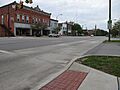
Main Street runs concurrently with U.S. Route 20 and State Route 105 in downtown Woodville
-
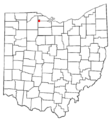
Location of Woodville, Ohio
-
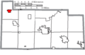
Location of Woodville in Sandusky County
-
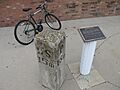
The 1842 milestone on the Western Reserve and Maumee Turnpike marks a point 16 miles from Perrysburg and 15 miles from Lower Sandusky (now Fremont).
See also
 In Spanish: Woodville (Ohio) para niños
