Wooldridge, Missouri facts for kids
Quick facts for kids
Wooldridge, Missouri
|
|
|---|---|
|
Village
|
|

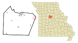
Location of Wooldridge, Missouri
|
|
| Country | United States |
| State | Missouri |
| County | Cooper |
| Area | |
| • Total | 0.06 sq mi (0.16 km2) |
| • Land | 0.06 sq mi (0.16 km2) |
| • Water | 0.00 sq mi (0.00 km2) |
| Elevation | 581 ft (177 m) |
| Population
(2020)
|
|
| • Total | 28 |
| • Density | 466.67/sq mi (179.78/km2) |
| Time zone | UTC-6 (Central (CST)) |
| • Summer (DST) | UTC-5 (CDT) |
| ZIP code |
65287
|
| Area code(s) | 660 |
| FIPS code | 29-81016 |
| GNIS feature ID | 2399740 |
Wooldridge is a small village located in the northeastern part of Cooper County, Missouri, in the United States. In 2010, the village had a population of 61 people. By 2020, the population was 28.
Contents
History of Wooldridge
Wooldridge was first planned and set up in 1901. The village was named after Dr. Wooldridge, who owned the land where the town was built. A post office opened in Wooldridge in 1902 and has been operating ever since.
2022 Fire Incident
On October 22, 2022, a large fire caused a lot of damage in Wooldridge. The fire destroyed 23 buildings, which was about half of the village. Because of a drought (a long period with very little rain) and strong winds, the fire spread very quickly.
Geography of Wooldridge
Wooldridge is found along Missouri Route 179 in the northeast corner of Cooper County. The Missouri River floodplain is right next to the northeast side of the community. A floodplain is a flat area of land next to a river that can get flooded.
The city of Boonville is about eleven miles northwest of Wooldridge. Columbia is nine miles to the northeast, in nearby Boone County.
According to the United States Census Bureau, the village covers a total area of 0.06 square miles (0.16 square kilometers). All of this area is land.
Population and People
| Historical population | |||
|---|---|---|---|
| Census | Pop. | %± | |
| 1910 | 119 | — | |
| 1920 | 160 | 34.5% | |
| 1930 | 157 | −1.9% | |
| 1940 | 178 | 13.4% | |
| 1950 | 137 | −23.0% | |
| 1960 | 100 | −27.0% | |
| 1970 | 97 | −3.0% | |
| 1980 | 79 | −18.6% | |
| 1990 | 54 | −31.6% | |
| 2000 | 47 | −13.0% | |
| 2010 | 61 | 29.8% | |
| 2020 | 28 | −54.1% | |
| U.S. Decennial Census | |||
2010 Census Details
In 2010, the census showed that 61 people lived in Wooldridge. There were 32 households and 15 families in the village. A household means all the people living in one home.
The population density was about 1,017 people per square mile (393 people per square kilometer). This means how many people live in a certain amount of space. There were 39 housing units, which are places where people can live.
Most of the people in the village (96.7%) were White. A small number were Native American (1.6%) or from other races (1.6%). About 11.5% of the population identified as Hispanic or Latino.
Out of the 32 households:
- 21.9% had children under 18 living with them.
- 25.0% were married couples living together.
- 15.6% had a female head of the household with no husband present.
- 6.3% had a male head of the household with no wife present.
- 53.1% were not families (meaning one person living alone or unrelated people living together).
The average household had 1.91 people, and the average family had 2.80 people. The median age in the village was 42.8 years old. This means half the people were younger and half were older than 42.8.
- 18% of residents were under 18 years old.
- 13.2% were between 18 and 24 years old.
- 19.7% were between 25 and 44 years old.
- 46% were between 45 and 64 years old.
- 3.3% were 65 years old or older.
The village had slightly more females (52.5%) than males (47.5%).
See also
 In Spanish: Wooldridge (Misuri) para niños

