Worcester, Vermont facts for kids
Quick facts for kids
Worcester, Vermont
|
|
|---|---|
 |
|

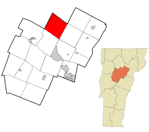
Location in Washington County and the state of Vermont
|
|
| Country | United States |
| State | Vermont |
| County | Washington |
| Communities |
|
| Area | |
| • Total | 38.8 sq mi (100.6 km2) |
| • Land | 38.7 sq mi (100.4 km2) |
| • Water | 0.1 sq mi (0.2 km2) |
| Elevation | 1,198 ft (365 m) |
| Population
(2020)
|
|
| • Total | 964 |
| • Density | 24.85/sq mi (9.583/km2) |
| Time zone | UTC-5 (Eastern (EST)) |
| • Summer (DST) | UTC-4 (EDT) |
| ZIP code |
05682
|
| Area code(s) | 802 |
| FIPS code | 50-86125 |
| GNIS feature ID | 1462273 |
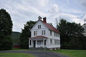
Worcester is a small town in Vermont, a state in the United States. It's located in Washington County. In 2020, about 964 people lived there.
Contents
A Look Back: Worcester's History
Worcester became an official town on June 8, 1763. It was given its charter by a governor from New Hampshire. This governor was loyal to the British king at the time. Sadly, many of the town's first records were lost. A fire destroyed them a long time ago. Because of this, we don't know the exact date the town was fully set up.
Where is Worcester?
Worcester covers about 38.8 square miles (100.6 square kilometers). Most of this area is land. Only a tiny part is water. The main part of the town is the village of Worcester.
Worcester's Weather
Worcester has a climate with warm summers and cold, snowy winters. Here's a quick look at the average temperatures and precipitation:
| Climate data for Worcester 2 W, Vermont, 1991–2020 normals: 1360ft (415m) | |||||||||||||
|---|---|---|---|---|---|---|---|---|---|---|---|---|---|
| Month | Jan | Feb | Mar | Apr | May | Jun | Jul | Aug | Sep | Oct | Nov | Dec | Year |
| Mean daily maximum °F (°C) | 26.0 (−3.3) |
29.1 (−1.6) |
37.9 (3.3) |
50.9 (10.5) |
64.6 (18.1) |
72.4 (22.4) |
76.9 (24.9) |
74.8 (23.8) |
67.6 (19.8) |
54.1 (12.3) |
41.6 (5.3) |
30.9 (−0.6) |
52.2 (11.2) |
| Daily mean °F (°C) | 17.1 (−8.3) |
19.7 (−6.8) |
28.2 (−2.1) |
41.4 (5.2) |
54.3 (12.4) |
62.8 (17.1) |
67.3 (19.6) |
65.3 (18.5) |
57.8 (14.3) |
45.9 (7.7) |
34.5 (1.4) |
23.9 (−4.5) |
43.2 (6.2) |
| Mean daily minimum °F (°C) | 8.3 (−13.2) |
10.3 (−12.1) |
18.6 (−7.4) |
31.9 (−0.1) |
44.1 (6.7) |
53.2 (11.8) |
57.7 (14.3) |
55.7 (13.2) |
48.0 (8.9) |
37.6 (3.1) |
27.5 (−2.5) |
17.0 (−8.3) |
34.2 (1.2) |
| Average precipitation inches (mm) | 3.17 (81) |
2.82 (72) |
3.13 (80) |
3.69 (94) |
4.27 (108) |
4.92 (125) |
4.76 (121) |
4.39 (112) |
3.39 (86) |
4.28 (109) |
3.60 (91) |
3.87 (98) |
46.29 (1,177) |
| Average snowfall inches (cm) | 27.00 (68.6) |
28.50 (72.4) |
21.00 (53.3) |
8.00 (20.3) |
0.80 (2.0) |
0.00 (0.00) |
0.00 (0.00) |
0.00 (0.00) |
0.00 (0.00) |
2.10 (5.3) |
10.40 (26.4) |
27.80 (70.6) |
125.6 (318.9) |
| Source: NOAA | |||||||||||||
Businesses and Services
Worcester has a local grocery store called LBJ's Grocery. Right next door, you'll find the Post Office Cafe. It opened in 2012 and shares a building with the town's post office.
The Vermont Association of Snow Travelers has a trail network that goes through Worcester. This is great for snowmobiling!
Most homes and businesses get their water from private wells. Some get water from the town's public water system. Electricity is supplied by Green Mountain Power and Washington Electric Cooperative. Cell phone service can be limited in some parts of town.
Who Lives in Worcester?
The number of people living in Worcester has changed over the years. Here's how the population has grown and shrunk:
| Historical population | |||
|---|---|---|---|
| Census | Pop. | %± | |
| 1800 | 25 | — | |
| 1810 | 41 | 64.0% | |
| 1820 | 44 | 7.3% | |
| 1830 | 432 | 881.8% | |
| 1840 | 567 | 31.3% | |
| 1850 | 702 | 23.8% | |
| 1860 | 684 | −2.6% | |
| 1870 | 775 | 13.3% | |
| 1880 | 802 | 3.5% | |
| 1890 | 725 | −9.6% | |
| 1900 | 636 | −12.3% | |
| 1910 | 694 | 9.1% | |
| 1920 | 463 | −33.3% | |
| 1930 | 471 | 1.7% | |
| 1940 | 396 | −15.9% | |
| 1950 | 445 | 12.4% | |
| 1960 | 417 | −6.3% | |
| 1970 | 505 | 21.1% | |
| 1980 | 727 | 44.0% | |
| 1990 | 906 | 24.6% | |
| 2000 | 902 | −0.4% | |
| 2010 | 998 | 10.6% | |
| 2020 | 964 | −3.4% | |
| U.S. Decennial Census | |||
In 2000, there were 902 people living in Worcester. They lived in 346 households. About 34% of these households had children under 18. Most people were White. A small number were Native American or from other backgrounds.
The average age in Worcester in 2000 was 38 years old. About 26% of the population was under 18. This means there were many kids and teenagers living in the town!
See also
 In Spanish: Worcester (Vermont) para niños
 | John T. Biggers |
 | Thomas Blackshear |
 | Mark Bradford |
 | Beverly Buchanan |


