Black Pig's Dyke facts for kids
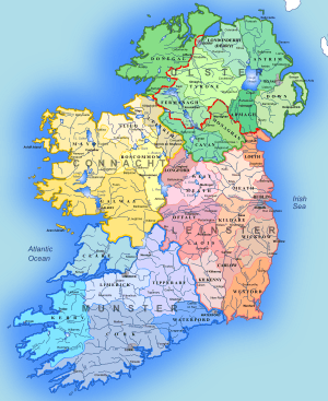
The Black Pig's Dyke (which means "Ditch of the Black Pig" in Irish) is a series of old earthworks found in parts of Ulster and Connacht, two of Ireland's historic provinces. These earthworks are like long lines of banks and ditches. You can still see parts of them in northern County Leitrim, northern County Longford, County Cavan, County Monaghan, and County Fermanagh. Some people also think that the Dorsey enclosure in County Armagh and the Dane's Cast in County Down are connected to the Black Pig's Dyke.
There are other similar earthworks across Ireland, but the Black Pig's Dyke is the most famous. For example, there's the Claidh Dubh ("black ditch") in eastern County Cork. One part of it stretches for about 24 kilometers (15 miles) from the Ballyhoura Hills to the Nagle Mountains.
What's in a Name?
The Black Pig's Dyke gets its name from old Irish stories and legends. In Counties Leitrim and Cavan, people usually call it the Black Pig's Dyke or Dike. In County Longford, it's known as the Black Pig's Race. Along the border between Cavan and Monaghan, it's called either the Black Pig's Dyke or the Worm Ditch.
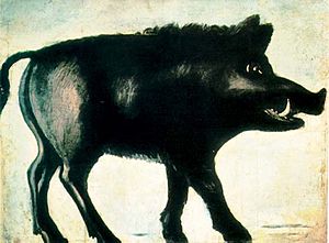
One popular story says that a huge black boar (a type of wild pig) tore up the land with its giant tusks, creating these ditches. Another tale suggests that a massive worm was responsible for digging them.
How It Was Built and Why

The Black Pig's Dyke usually looks like a raised bank with a ditch on each side. The bank is typically about 9 meters (30 feet) wide, and the ditches are around 6 meters (20 feet) deep.
Archaeologists have dug up parts of the dyke in County Monaghan. They found that it was originally built with a strong timber palisade (a tall fence made of wooden stakes) and a ditch outside it. Behind this fence, there was a double bank with another ditch in between. Scientists used a method called radiocarbon dating to figure out when the timber was used. They found it was from around 390–370 BCE. This means the entire Black Pig's Dyke could be that old! This discovery helped to show that the dyke was not built to copy Roman borders, as some once thought, because it's much older than the Roman presence in Britain.
People have different ideas about why these earthworks were built:
- Ancient Border: Some believe the dyke marked the old border of Ulster. However, there are big gaps between the different sections, and they might not have all been built at the same time. So, it's not clear if they were all part of one big border.
- Stopping Raids: Another popular idea is that the dyke was built to stop cattle raiding. Stealing cattle was very common in ancient Ireland. The earthworks would have made it harder for raiders to move large herds of animals quickly.
Why are there large gaps in the dyke? There are two main theories:
- The dyke might have only been built across important pathways that cattle raiders often used.
- The gaps might have once been covered by thick forests, which would have acted as a natural barrier, so no man-made defense was needed there.
Where to Find It
You can still see parts of the Black Pig's Dyke in these areas:
- North County Leitrim: It runs from Lough Melvin to Lough MacNean, near the villages of Rossinver and Kiltyclogher.
- Northeast County Longford: This section stretches for about 10 kilometers (6 miles) from Lough Gowna to Lough Kinale, crossing the N55 road, near the villages of Dring and Granard.
- County Cavan–County Monaghan Border: It runs roughly from west to east, starting near the Finn River (close to Redhills) and going to the townland of Corrinshigo (near Drum).
- County Cavan: A well-preserved section forms a wide semi-circle in the townland of Ardkill More, about 3½ miles east of Bellananagh. Local heritage groups have asked for a nearby quarry to stop its work, as they believe it is damaging this part of the dyke.
- County Fermanagh: Parts of the earthwork are found in Lislea townland and in Mullynavannoge townland. These are protected as Scheduled Historic Monuments.


