
Wragby facts for kids
Quick facts for kids Wragby |
|
|---|---|
| Town and civil parish | |
 All Saints Church, Wragby |
|

Wragby
|
|
| Population | 1,861 (2021) |
| OS grid reference | TF132780 |
| • London | 125 mi (201 km) S |
| Civil parish |
|
| District | |
| Shire county | |
| Region | |
| Country | England |
| Sovereign state | United Kingdom |
| Post town | Market Rasen |
| Postcode district | LN8 |
| Dialling code | 01673 |
| Police | Lincolnshire |
| Fire | Lincolnshire |
| Ambulance | East Midlands |
| EU Parliament | East Midlands |
| UK Parliament |
|
Wragby (/ˈræɡbi/ RAG-bee) is a small, historic market town and civil parish in Lincolnshire, England. It is located in the East Lindsey area. You can find it where the A157 and A158 roads meet. It is about 10 miles (16 km) north-west of Horncastle and 11 miles (18 km) north-east of Lincoln.
Contents
Wragby's Past
Wragby has a long history! It was first mentioned in the Domesday Book. This was a very old survey of England from 1086. Back then, Wragby was called "Waragebi". It had 23 homes, a mill, and a church.
Ancient Manor Complex
There is a special historical site called the 'Rout Yard'. This site has two moated islands and old ditches. It is what remains of a medieval manor complex. A manor was a large estate ruled by a lord.
In 1086, Wragby had two manors. The 'Rout Yard' might be the remains of one of these. This manor was responsible for a church. The old church was taken down in 1836. A new church was built closer to the town centre.
All Saints' Church
The ruins of the older church are no longer visible today. However, a local history group has marked the site. They have put up information boards there. Some items from the old church are now in the current All Saints Church, Wragby.
The present-day All Saints Church, Wragby was built in 1839. It was designed by W. A. Nicholson. The local heritage group has cleared the old church site. They also repaired damaged tombs and headstones.
Market Town Life
Wragby became a market town and a stopping point for travellers. This was thanks to a special permission from King Charles II. The town held a market every Thursday. There were also two fairs each year.
In the early 1900s, eggs and butter were still sold at the market. The cattle market continued even after the Second World War.
Old Buildings and Local History
A grammar school was started in 1635. It was rebuilt in 1775. Both buildings are now used as homes. There was also a windmill built in 1831. It had six sails and stopped working in 1903.
In 1883, the last European wildcat in England was killed near Wragby. This happened in Bullington Wood.
Modern Wragby
Today, Wragby is a popular stop for people travelling to Skegness. It has places like pubs, a fish and chip shop, a cafe, and a supermarket. The town has grown with new housing estates.
A band called The Sinking Ships came from Wragby. They formed in 1979. They are known for their song Strangers.
Population Details
At the 2021 census, Wragby's built-up area had 1,861 people. Here is a look at the different groups of people living there:
Ethnicity in Wragby
| Wragby: Ethnicity: 2021 Census | |||||||||||||
| Ethnic group | Population | % | |||||||||||
|---|---|---|---|---|---|---|---|---|---|---|---|---|---|
| White | 1,805 | 97.1% | |||||||||||
| Mixed | 29 | 1.6% | |||||||||||
| Asian or Asian British | 24 | 1.3% | |||||||||||
| Other Ethnic Group | 1 | 0.1% | |||||||||||
| Total | 1,861 | 100% | |||||||||||
Religions in Wragby
The census also recorded the religious groups in Wragby:
| Wragby: Religion: 2021 Census | |||||||||||||
| Religious | Population | % | |||||||||||
|---|---|---|---|---|---|---|---|---|---|---|---|---|---|
| Christian | 1,029 | 58.9% | |||||||||||
| Irreligious | 687 | 39.3% | |||||||||||
| Muslim | 10 | 0.6% | |||||||||||
| Other religion | 7 | 0.4% | |||||||||||
| Buddhist | 4 | 0.2% | |||||||||||
| Hindu | 4 | 0.2% | |||||||||||
| Sikh | 4 | 0.2% | |||||||||||
| Jewish | 2 | 0.1% | |||||||||||
| Total | 1,861 | 100% | |||||||||||
Railway History
Wragby once had its own railway station. It was part of the Louth to Bardney Line. The station opened in 1874. It was located on Horncastle Road.
The station closed to passengers in 1951. It fully closed for goods in 1960. Houses and roads now cover the railway line. However, the old station building and platform are still there as a private home.
How Wragby is Governed
Wragby is an electoral ward. This is an area used for local elections. The ward stretches east and had a total population of 2,469 in 2011.
Wragby is also a civil parish. It has a parish council. This is the lowest level of local government. The parish includes some farms and houses outside the main town.
Images for kids
-
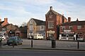
Market Place, Wragby

See also
 In Spanish: Wragby para niños
