Wyatt, Missouri facts for kids
Quick facts for kids
Wyatt, Missouri
|
|
|---|---|

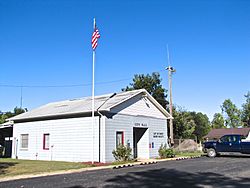
Wyatt City Hall
|
|

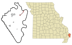
Location in Mississippi County and the state of Missouri
|
|
| Country | United States |
| State | Missouri |
| County | Mississippi |
| Area | |
| • Total | 1.23 sq mi (3.18 km2) |
| • Land | 1.17 sq mi (3.04 km2) |
| • Water | 0.06 sq mi (0.15 km2) |
| Elevation | 308 ft (94 m) |
| Population
(2020)
|
|
| • Total | 219 |
| • Density | 186.86/sq mi (72.16/km2) |
| Time zone | UTC-6 (Central (CST)) |
| • Summer (DST) | UTC-5 (CDT) |
| ZIP code |
63882
|
| Area code(s) | 573 |
| FIPS code | 29-81178 |
| GNIS feature ID | 2397384 |
Wyatt is a small city located in Mississippi County, Missouri, in the United States. In 2020, about 219 people lived there. This city is special because it's the farthest east city on the west side of the big Mississippi River.
History of Wyatt
Wyatt was first known as "Pevey Switch." It started in 1881 when a railroad line was built to that spot. A post office opened in Wyatt in 1895. The city was named after William Wyatt, who was one of the first people to settle there.
A railroad line called the Cotton Belt used to run for about 5.3 miles (8.5 km) between Bird's Point and Wyatt. This part of the line was closed in 1938. Later, in 1941, an oil pipeline was built along the old railroad path. This pipeline helped move crude oil by barges on the river. The Cotton Belt railroad would bring oil in tank cars from states like Arkansas, Louisiana, and Texas to Wyatt. From there, the oil went through the pipeline to Bird's Point and then onto barges. Another part of the railroad, about 8.7 miles (14 km) long, between Wyatt and East Prairie, was closed in 1980.
Wyatt's Geography
Wyatt is located on Missouri Route 77 in the eastern part of Mississippi County. It is about 5 miles (8 km) west and southwest of the Mississippi River. The small town of Wilson City is just north of Wyatt, across U.S. Route 62. Wyatt is also on the western edge of an area called the Birds Point-New Madrid Floodway.
The U.S. Census Bureau says that the city covers a total area of about 1.23 square miles (3.18 sq km). Most of this area, about 1.17 square miles (3.04 sq km), is land. The remaining 0.06 square miles (0.15 sq km), or about 4.56%, is water.
Population Facts
| Historical population | |||
|---|---|---|---|
| Census | Pop. | %± | |
| 1930 | 199 | — | |
| 1940 | 417 | 109.5% | |
| 1950 | 345 | −17.3% | |
| 1960 | 711 | 106.1% | |
| 1970 | 562 | −21.0% | |
| 1980 | 441 | −21.5% | |
| 1990 | 376 | −14.7% | |
| 2000 | 364 | −3.2% | |
| 2010 | 319 | −12.4% | |
| 2020 | 219 | −31.3% | |
| U.S. Decennial Census | |||
How Many People Live Here?
In 2010, a census counted 319 people living in Wyatt. There were 135 households, which are groups of people living together in one home. Out of these, 84 were families.
The city had about 272.6 people per square mile (105.3 per sq km). There were 164 housing units, like houses or apartments.
Most people in the city, about 84.33%, were White. About 15.05% were Black or African American. A small number, 0.63%, were from two or more races. Less than 1% of the population was Hispanic or Latino.
Out of the 135 households:
- 33.3% had children under 18 living with them.
- 45.9% were married couples living together.
- 10.4% had a female head of the house with no husband.
- 5.9% had a male head of the house with no wife.
- 37.8% were not families.
About 33.3% of all households had only one person living there. Also, 12.6% of households had someone aged 65 or older living alone. The average household had 2.36 people, and the average family had 3.00 people.
The average age of people in Wyatt was 37.9 years old.
- 27% of residents were under 18.
- 6.9% were between 18 and 24.
- 23.5% were between 25 and 44.
- 27.6% were between 45 and 64.
- 15% were 65 or older.
The city's population was almost evenly split between genders: 50.5% were male and 49.5% were female.
See also
 In Spanish: Wyatt (Misuri) para niños
 | John T. Biggers |
 | Thomas Blackshear |
 | Mark Bradford |
 | Beverly Buchanan |

