
Yarwun, Queensland facts for kids
Yarwun is a small town and coastal area located in the Gladstone Region of Queensland, Australia. In 2021, about 89 people lived in Yarwun. It's known for its industrial sites and a quiet, rural feel.
Quick facts for kids YarwunQueensland |
|||||||||||||||
|---|---|---|---|---|---|---|---|---|---|---|---|---|---|---|---|
,_relocated_in_2003_to_Calliope_River_Historical_Village_(closeup),_2014.JPG)
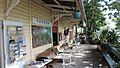
Former Yarwun railway station (now at Calliope River Historical Village), 2014
|
|||||||||||||||

Yarwun
Location in Queensland
|
|||||||||||||||
| Population | 89 (2021 census) | ||||||||||||||
| • Density | 1.660/km2 (4.30/sq mi) | ||||||||||||||
| Postcode(s) | 4694 | ||||||||||||||
| Area | 53.6 km2 (20.7 sq mi) | ||||||||||||||
| Time zone | AEST (UTC+10:00) | ||||||||||||||
| Location |
|
||||||||||||||
| LGA(s) | Gladstone Region | ||||||||||||||
| State electorate(s) | Gladstone | ||||||||||||||
| Federal Division(s) | Flynn | ||||||||||||||
|
|||||||||||||||
Contents
Exploring Yarwun's Geography
Yarwun's landscape includes flat areas and gentle hills. The land rises from sea level up to about 320 meters (1,050 feet). There are no tall mountains or famous peaks here.
How Railways Connect Yarwun
The main North Coast railway line runs through Yarwun. It helps connect the town to other places. There are three railway stations in the area. One is on the main line, and two others are on special branch lines. These branch lines go to big industrial sites.
- Yarwun railway station (on the main line)
- Fishermans Landing railway station (on a branch line)
- Comalco railway station (on a branch line)
The Gladstone–Mount Larcom Road also passes through Yarwun. This road is important for travel and transport in the region.
A Look at Yarwun's History
Yarwun has an interesting past, especially with its school and local businesses.
The Story of Yarwun School
Yarwun Provisional School first opened its doors on June 5, 1906. It became Yarwun State School in 1909. The school moved to the center of town in the late 1990s. This move happened because the railway line needed to be made straighter and wider.
Growing Fruit and Community Spirit
In 1924, local farmers created the Yarwun-Targinnie Co-operative Association. This group helped sell fruit grown in the area. Yarwun was especially known for its delicious pawpaws. In 1963, the Co-op opened a store on Butler Street. It sold things needed for fruit farming, like wooden boxes. Later, the store started selling general goods and even offered postal services to the community.
Big Industry Comes to Town
In March 2005, a large company called Rio Tinto Alcan opened an alumina refinery in Yarwun. An alumina refinery turns a raw material called bauxite into alumina. Bauxite comes from a place called Weipa. The refinery uses a special method called the Bayer process to do this.
The refinery grew even bigger in 2012. It added a 160-megawatt co-generation facility. This facility is amazing because it turns heat into electricity! The refinery is a major employer in the area.
The Railway Station's New Home
In June 2003, the old Yarwun railway station was moved. It found a new home at the Calliope River Historical Village. Now, it serves as a ticket office and kiosk there.
Yarwun's Economy and Jobs
Yarwun's economy is mainly driven by its large industrial plants. These plants provide many jobs for people in the region.
Producing Alumina for the World
The alumina refinery in Yarwun is very important. It can produce 3.4 million tonnes of alumina every year. This huge plant employs more than 700 people. Alumina is used to make aluminum, which is used in many products we use every day.
Making Materials for Mining
Another big company in Yarwun is Orica. It operates an ammonium nitrate plant. This plant makes over 500,000 tonnes of ammonium nitrate each year. This material is used in the mining industry both in Australia and other countries. Orica has about 200 employees and 100 contractors working at its Yarwun site. Raw materials for the plant arrive at Fisherman's Landing and are sent to the plant through underground pipes.
Education in Yarwun
Yarwun State School is the main school for younger students in the area.
Learning at Yarwun State School
Yarwun State School is a government primary school for students from Prep to Year 6. It is located at 35 Butler Street. In 2018, the school had 33 students. They were taught by 4 teachers, with additional non-teaching staff helping out.
Secondary School Options
There isn't a secondary school right in Yarwun. Older students usually travel to nearby towns for high school. The closest government secondary schools are Gladstone State High School in West Gladstone (for students up to Year 12) and Mount Larcom State School in Mount Larcom (for students up to Year 10).
Community Facilities
Yarwun has important facilities that serve the community and local industries.
Yarwun Water Treatment Plant
The Yarwun Water Treatment Plant is located on Reid Road. It is managed by the Gladstone Regional Council. This plant plays a vital role in making sure the community has clean and safe water.
Images for kids
-
Former Yarwun railway station, now at Calliope River Historical Village.
