
Yosemite Lakes Park, California facts for kids
Quick facts for kids
Yosemite Lakes
|
|
|---|---|

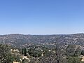
View of Yosemite Lakes Park from Lilly Mountain
|
|

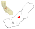
Location in Madera County and the state of California
|
|

Yosemite Lakes Park, California
Location in the United States
|
|
| Country | |
| State | |
| County | Madera |
| Area | |
| • Total | 20.999 sq mi (54.387 km2) |
| • Land | 20.902 sq mi (54.136 km2) |
| • Water | 0.097 sq mi (0.251 km2) 0.46% |
| Elevation | 1,263 ft (385 m) |
| Population
(2020)
|
|
| • Total | 5,022 |
| • Density | 240.3/sq mi (92.8/km2) |
| Time zone | UTC-8 (Pacific) |
| • Summer (DST) | UTC-7 (PDT) |
| ZIP code |
93614 (Coarsegold)
|
| Area code | 559 |
| FIPS code | 06-86878 |
| GNIS feature IDs | 1867075, 2409637 |
Yosemite Lakes Park is a community in Madera County, California. It's not officially a city, but it's a special area counted by the government called a census-designated place (CDP), known as Yosemite Lakes. It's located about 1,230 feet (375 meters) above sea level.
This community is part of the larger Madera area. In 2020, about 5,022 people lived here.
The area was built in the 1970s by a group called Titan Group. It has cool features like a place for horses, a clubhouse, and three lakes made by people. There's also a homeowners association that runs a restaurant called Blue Heron and the Fairway Cafe, which is next to the golf course. You can also find a local grocery store and other small shops in the community.
Contents
Exploring Yosemite Lakes
Where is Yosemite Lakes?
Yosemite Lakes is nestled in the foothills of the Sierra Nevada mountains. It's located at coordinates 37°11′28″N 119°46′22″W. The Fresno River forms its northwest border. To the south and east, you'll find Coarsegold Creek.
The community of Coarsegold is just northeast of Yosemite Lakes. It's also about 34 miles (55 km) north of Fresno. The total area of Yosemite Lakes is about 21 square miles (54 square kilometers). A small part, about 0.1 square miles (0.25 square kilometers), is water.
Lilley Mountain: A Local Landmark
The highest point in the community is Lilley Mountain, which stands at 1,929 feet (588 meters) tall. This mountain was a well-known landmark for drivers traveling from Fresno on their way to the famous Yosemite National Park.
Community Life and People
Who Lives in Yosemite Lakes?
The 2010 United States Census showed that 4,952 people lived in Yosemite Lakes. Most residents, about 89%, were White. There were also people from other backgrounds, including African American, Native American, Asian, and Pacific Islander. About 10.4% of the population identified as Hispanic or Latino.
The community is made up of many families. About 29.9% of households had children under 18. The average household had about 2.6 people. Many people own their homes here, with about 84.8% of homes being owner-occupied.
Changes Over Time
Back in 2000, the population was 4,160 people. The community has grown since then! The average age in 2000 was 43 years old. In 2010, the median age was 47.2 years, meaning half the people were older and half were younger than that age.
The median income for a household in 2000 was $56,382. This means that half the households earned more than this amount, and half earned less. Only a small percentage of families, about 3.5%, were living below the poverty line at that time.
Images for kids
-
View of Yosemite Lakes Park from Lilly Mountain
-
Location in Madera County and the state of California
