2010 Yushu earthquake facts for kids
| UTC time | 2010-04-13 23:49:38 |
|---|---|
| ISC event | 14573075 |
| USGS-ANSS | ComCat |
| Local date | April 14, 2010 |
| Local time | 07:49 local time |
| Magnitude | 6.9 Mw 7.1 Ms |
| Depth | 17 km (11 mi) |
| Epicenter | 33°09′54″N 96°37′44″E / 33.165°N 96.629°E |
| Areas affected | Qinghai, Sichuan, People's Republic of China |
| Max. intensity | IX (Violent) CSIS IX |
| Foreshocks | Yes |
| Casualties | 2,698 confirmed dead 12,135 injured 270 missing (presumed dead) |
The 2010 Yushu earthquake was a powerful earthquake that hit Yushu, Qinghai, China, on April 14, 2010. It happened at 7:49 am local time. The earthquake was very strong, with a magnitude of 6.9 or 7.1 on different scales.
The ground shook violently, causing a lot of damage. Sadly, 2,698 people were confirmed dead, and 12,135 people were injured. Another 270 people went missing. The earthquake's starting point, called the epicenter, was in a quiet, rugged area near the border of the Tibet Autonomous Region. This area is on the Tibetan Plateau, where earthquakes happen often.
A very old place called Thrangu Monastery, built in the 12th century, was badly damaged. Many monks and people in the nearby villages also lost their lives.
Contents
What Caused the Earthquake?

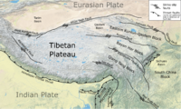
The area where the earthquake happened, Qinghai, is in the northeastern part of the Tibetan Plateau. This plateau was formed because two huge pieces of the Earth's crust, called plates, are slowly pushing into each other. Imagine two giant puzzle pieces of the Earth's surface colliding! These are the Indian Plate and the Eurasian Plate.
When these plates push together, the ground gets squeezed and pushed up, forming mountains like the Himalayas. But sometimes, instead of just pushing, the plates also slide past each other. This sliding happens along cracks in the Earth's crust called fault lines.
The Yushu Fault Line
The 2010 Yushu earthquake happened on a specific fault line called the Yushu fault. This fault is part of a bigger system of cracks known as the Yushu-Garzê-Xianshuihe fault zone. This zone is one of the most active places for earthquakes in eastern Tibet.
Many strong earthquakes, even bigger than magnitude 7, have happened along this fault zone in the past. Scientists study these fault lines to understand where future earthquakes might occur.
How the Earthquake Happened
Before the main earthquake, there were smaller shakes called foreshocks. The biggest foreshock was a magnitude 4.9, and it happened about two hours before the main quake. After the main earthquake, there were more shakes called aftershocks. One strong aftershock, with a magnitude of 6.1, happened less than two hours later.
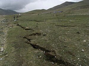
Scientists studied the ground and used special radar to see how much the Earth's surface moved. They found that the ground cracked for about 80 kilometers (50 miles). They also learned that the earthquake rupture spread very quickly, faster than normal sound waves in the Earth. This type of earthquake is called a supershear earthquake.
Damage and Rescue Efforts
The earthquake caused a lot of destruction. In Gyegu, the main town in Yushu, over 85% of the buildings were destroyed. Most of these buildings were made of wood and earth, which are not very strong against earthquakes. Hundreds of people were trapped, and thousands lost their homes. A school collapsed, trapping many students inside. The power also went out in Gyegu.
The town of Jiegu was hit the hardest, with more than 94% of its buildings destroyed. The shaking was so strong there that it reached a very high intensity level.
In a nearby province called Sichuan, people also felt strong shaking. Roads were damaged in some areas there.
Getting Help to Survivors
Because the area was very rugged and the roads were damaged by landslides, it was hard for rescue teams to get there at first. Soldiers from the People's Armed Police and People's Liberation Army were among the first to arrive and help.
The government quickly sent supplies to help the survivors. They sent:
- 5,000 tents for shelter
- 100,000 warm coats
- Heavy blankets
These supplies were important because the weather was cold, with strong winds and temperatures near freezing.
The local airport, Yushu Batang Airport, was quickly reopened. This allowed the China International Earthquake Rescue Team to fly in with more people and supplies.
Even a dam, the Changu Dam, was damaged by the earthquake. It was at risk of collapsing, which would have caused even more problems.
Aftershocks List
The main earthquake was followed by several aftershocks. Four of these were stronger than magnitude 5. One notable aftershock was a magnitude 5.8 quake on April 14.
Here is a list of the stronger shakes that happened:
| Date (YYYY-MM-DD) |
Time (UTC) |
Latitude | Longitude | Depth | Magnitude |
|---|---|---|---|---|---|
| 2010-04-13 | 21:40:00 | 33.183° N | 96.623° E | 18.9 km (12 mi) | 5.0 (Mw) |
| 2010-04-13 | 23:49:39 | 33.224° N | 96.666° E | 17.0 km (11 mi) | 6.9 (Mw) |
| 2010-04-14 | 00:01:17 | 32.875° N | 96.999° E | 10.0 km (6 mi) | 5.3 (Mw) |
| 2010-04-14 | 00:12:25 | 33.159° N | 96.580° E | 10.0 km (6 mi) | 5.2 (Mw) |
| 2010-04-14 | 01:25:15 | 33.179° N | 96.448° E | 4.0 km (2 mi) | 5.8 (Mw) |
| 2010-04-17 | 00:59:01 | 32.588° N | 92.743°E | 40.6 km (25 mi) | 5.1 (Mw) |
See also
- List of earthquakes in 2010
- List of earthquakes in China
 | Audre Lorde |
 | John Berry Meachum |
 | Ferdinand Lee Barnett |


