A' Bhuidheanach Bheag facts for kids
Quick facts for kids A' Bhuidheanach Bheag |
|
|---|---|

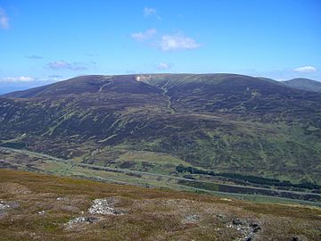
A' Bhuidheanach Bheag seen across the Pass of Drumochter from The Sow of Atholl.
|
|
| Highest point | |
| Elevation | 936 m (3,071 ft) |
| Prominence | c. 111 m |
| Listing | Munro |
| Naming | |
| English translation | Little Yellow Place |
| Language of name | Gaelic |
| Geography | |
| Parent range | Grampian Mountains |
| OS grid | NN660776 |
| Topo map | OS Landranger 42, OS Explorer 394 |
| Listed summits of A' Bhuidheanach Bheag | ||||
| Name | Grid ref | Height | Status | |
|---|---|---|---|---|
| Glas Mheall Mòr | NN680769 | 928 m (3044 ft) | Munro Top | |
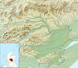
A' Bhuidheanach Bheag is a Scottish mountain. It is located on the eastern side of the Pass of Drumochter. This is about 24 kilometers (15 miles) northwest of Blair Atholl. The mountain sits on the border between the Highland and Perth and Kinross areas. However, its very top is found in Perth and Kinross.
Contents
Exploring A' Bhuidheanach Bheag
The land east of the Pass of Drumochter is a huge, wavy plateau. A plateau is a large, flat area of high ground. This one is usually over 800 meters (2,600 feet) high. It stretches northeast for 13 kilometers (8 miles). This area is sometimes thought of as not very exciting. But it has two Munros, which are Scottish mountains over 3,000 feet (914.4 meters) high. These Munros attract many hikers.
A' Bhuidheanach Bheag is at the southern end of this plateau. If you look at it from the A9 road, you will see many shallow ditches and valleys. The actual summit, or top, is hidden from the A9. It sits further back from the plateau's edge. Because the land is gently rolling, A' Bhuidheanach Bheag is great for ski mountaineering. This means skiing up and down mountains.
What Makes This Mountain Special?
Even though it's not famous for being dramatic, A' Bhuidheanach Bheag offers a feeling of wide-open space. You can see the big skies of the high Grampian Mountains. Its gentle slopes are home to lots of wildlife. You might spot birds like the Eurasian dotterel and ptarmigan. You could also see grouse and mountain hare.
The mountain's name comes from the Gaelic language. It means "Little Yellow Place." This name probably refers to the rough, yellow grass that grows on its sides. The "Little" part of the name can be a bit confusing. This is because the mountain is the highest point in the southern part of the plateau. But it was named for how it looked from the valley below, not for its height.
Mountain Features and History
One of A' Bhuidheanach Bheag's most interesting features is the remote Cama Choire. A "choire" (or "cirque") is a bowl-shaped valley. This one is on the mountain's eastern side. It is a steep-sided valley that cuts deep into the hill. A stream called the Allt a’ Chama Choire flows out of it. You can see this coire well from the hill of An Dun.
How Ice Shaped the Land
From a geology point of view, the most interesting part is Coire Mhic-sith. This is on the mountain's southwestern side. This coire is a deep, narrow valley formed by a crack in the Earth's crust (a fault). Geologists, especially from the University of Edinburgh, have studied it. They found glacial silt and sand in the valley. They also found a glacial spillway. This is a channel where water from melting ice flowed.
These findings mean that a large lake was held back by ice during the last Ice age. This lake drained away when the ice melted. But it left behind evidence similar to the "parallel roads" in Glen Roy. These "roads" are old shorelines of a former glacial lake.
The Summit and Its Neighbors
The very top of the mountain is a gentle rise on the plateau. You can only easily spot it because of an OS trig point. A trig point is a marker used by surveyors to map the land. You will see some quartzite rocks scattered across the summit plateau. Some of these rocks have been gathered around the trig point. A few old metal fence posts are also there.
The OS map also shows another spot 936 meters (3,071 feet) high. This is half a kilometer (about a third of a mile) west of the main summit. The summit is crossed by a line of old, rusty fence posts. These posts lead straight to the nearby Munro called Càrn na Caim. This mountain is five kilometers (3 miles) to the north. It is across a wet, boggy dip in the land that is 825 meters (2,707 feet) high.
A' Bhuidheanach Bheag has two other smaller peaks over 3,000 feet. Glas Mheall Mòr is 928 meters (3,044 feet) high. It is about two kilometers (1.2 miles) to the east-southeast. It is listed as a "Munro Top." Meall a' Chaorainn is 916 meters (3,005 feet) high. It is 1.5 kilometers (0.9 miles) west of the summit. This peak was removed from the Munro tables in 1981. All the water from the mountain flows to the east coast of Scotland. Most of it goes south to the River Tay. A smaller amount goes north through Glen Truim to the River Spey.
How to Climb A' Bhuidheanach Bheag
Most people start their climb of A' Bhuidheanach Bheag from the A9 road. There are two main starting points. One is Balsporan Cottages. The other is 1.5 kilometers (0.9 miles) north, at the bottom of Coire Chuirn.
A more interesting way to climb starts from the quiet countryside to the east. You can begin at the ruined Sronphadruig Lodge. From there, you climb up through the Cama Choire to reach the plateau. Many hikers will continue their journey to the next Munro, Càrn na Caim. The plateau is quite flat and doesn't have many clear landmarks. So, it's very important to have a map and compass, especially if it's foggy.
 | Precious Adams |
 | Lauren Anderson |
 | Janet Collins |


