The Sow of Atholl facts for kids
Quick facts for kids The Sow of Atholl |
|
|---|---|
| Scottish Gaelic: Meall an Dobharchain | |

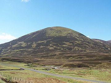
Seen from A9 road at the summit of the Pass of Drumochter.
|
|
| Highest point | |
| Elevation | 803 m (2,635 ft) |
| Prominence | 166 m (545 ft) |
| Listing | Corbett, Marilyn |
| Naming | |
| English translation | Watercress Hill (Meall an Dobharchain) |
| Language of name | Gaelic |
| Pronunciation | |
| Geography | |
| Location | Atholl, Perth and Kinross, Scotland |
| Parent range | Grampians |
| OS grid | NN624741 |
| Topo map | OS Landranger 42, OS Explorer 394 |
The Sow of Atholl (also known as Scottish Gaelic: Meall an Dobharchain) is a Scottish hill. It is located about 27 kilometers northwest of the town of Blair Atholl. This hill stands in the Perth and Kinross area of Scotland. You can find it on the west side of the Pass of Drumochter. It is part of a group of hills around a place called Coire Dhomhain.
Contents
About The Sow of Atholl
The Sow of Atholl is a steep, cone-shaped hill. It reaches a height of 803 meters (2,634 feet). This makes it a Corbett and a Marilyn. These are special lists of hills in the British Isles. The easiest slopes to climb are on its southeast side. This broad ridge leads down to Dalnaspidal Lodge. Many people start their climb from there.
The hill is very close to the A9 road and the Highland Main Line railway. These pass over the highest point of the Drumochter Pass. You can see the hill clearly from both the road and the railway.
What's in a Name?
The hill's unusual English name, "The Sow of Atholl," is thought to be a newer, more playful name. It was likely given to match another nearby hill called the Boar of Badenoch. The Boar of Badenoch is about 2.5 kilometers north of The Sow.
The hill's older and correct name is Meall an Dobharchain. This name comes from the Scottish Gaelic language. It means "Watercress Hill." This name refers to the wet, marshy ground on the lower southeast parts of the hill. Watercress used to grow there a long time ago.
In 1854, an old book called The New Statistical Account Of Scotland called the hill Carnan Dóbhrain. This name can be translated as "Small Cairn of the Otters."
Hill Features and Landscape
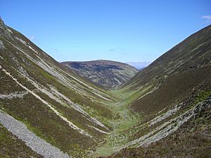
The Sow of Atholl has steep slopes covered in heather and grass. You might also see some scattered boulders. One interesting feature is the deep valley to the west of the hill. This valley makes it tricky to walk directly to the nearby mountain, Sgairneach Mhòr. Sgairneach Mhòr is a Munro (a mountain over 3,000 feet) located three kilometers southwest.
This unnamed valley is a great example of a glacial valley shaped like a parabola. It drops 200 meters from the Sow's summit in a short distance. While the slopes are not too hard to walk, most hikers prefer to go around the top of the valley. This makes it easier to travel between The Sow and Sgairneach Mhòr. This steep valley is also why The Sow is considered a separate mountain. It gives the hill enough prominence (how much it stands out from its surroundings).
All the rain that falls on The Sow flows south. It joins the drainage basin of the River Tay. Eventually, this water reaches the east coast of Scotland at the Firth of Tay.
Plants and Wildlife

The Sow of Atholl is home to some interesting plants. One special plant found here is Phyllodoce caerulea. This plant is also known as Norwegian blue heather. It is a subarctic plant, meaning it grows in cold, northern regions. It needs steep, rocky slopes and peaty soil to grow.
For a long time, The Sow of Atholl was thought to be the only place in the British Isles where Phyllodoce caerulea grew. However, it has now also been found in the Ben Alder mountain range. Other subarctic plants also grow on the hill. These include Cornus suecica (Eurasian dwarf cornel) and Sibbaldia procumbens.
Climbing The Sow
Climbing The Sow of Atholl is not too difficult. You can start directly from the A9 road. The starting point is already quite high, around 400 meters above sea level. The most popular place to begin your climb is Dalnaspidal Lodge. There is a place to park your car there. The area around the lodge can be quite wet and marshy, especially after rain. This is because of a sluice dam nearby.
The path goes straight up the southeast side of the hill. These are the least steep slopes. Starting at Dalnaspidal also gives you the chance to climb another hill called Meall na Leitreach. This Corbett is five kilometers south, across Loch Garry.
Another possible starting point is 2.5 kilometers further north on the A9. This is at the highest point of the Pass of Drumochter. However, the climb from here is steeper. You can also climb The Sow as part of a longer hike around Coire Dhomhain. This route includes other mountains like Sgairneach Mhòr, Beinn Udlamain, and A' Mharconaich.
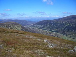
The very top of the hill has a small cairn. This is a pile of a few rocks. From the summit, you get amazing views both north and south down the Pass of Drumochter.
 | James B. Knighten |
 | Azellia White |
 | Willa Brown |


