Beinn Udlamain facts for kids
Quick facts for kids Beinn Udlamain |
|
|---|---|
| Beinn Ùdlamain (Scottish Gaelic) | |

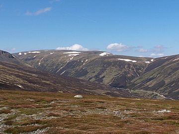
Beinn Udlamain from the east, the track up Coire Dhomhain is clearly in view.
|
|
| Highest point | |
| Elevation | 1,011 m (3,317 ft) |
| Prominence | 556 m (1,824 ft) |
| Listing | Munro, Marilyn |
| Naming | |
| English translation | Gloomy Mountain |
| Language of name | Gaelic |
| Geography | |
| Location | Perth and Kinross / Highland, Scotland |
| Parent range | Grampian Mountains |
| OS grid | NN579739 |
| Topo map | OS Landranger 42, OS Explorer 394 |
Beinn Udlamain is a mountain in Scotland. It stands near the Pass of Drumochter. You can find it east of Loch Ericht. The mountain is about 30 kilometers northwest of Blair Atholl village. Its top sits right on the border. This border separates the Highland and Perth and Kinross areas.
Contents
About Beinn Udlamain
Beinn Udlamain is 1011 meters (3317 feet) tall. This makes it a Munro. A Munro is a Scottish mountain over 3,000 feet high. It is also a Marilyn because it stands out a lot. Beinn Udlamain is the tallest of the Drumochter hills.
Why is it called Gloomy Mountain?
The mountain's name comes from Gaelic. Most people think "Udlamain" means "Gloomy Mountain." This comes from the word Ùdlaidh. It can mean gloomy or secluded. Some people also think the name means "hill of the unsteady place." Others say it means "hill of the shaking."
What does it look like?
Beinn Udlamain is not the most striking mountain. It has a flat top. Other Munros like Sgairneach Mhòr and A' Mharconaich block the view. You can't see it clearly from the A9 road. The best views are from other hills around Coire Dhomhain.
Exploring Beinn Udlamain
Beinn Udlamain has a long ridge at the top. This ridge runs from north to south. It stays above 970 meters for over 1.5 kilometers. The ridge connects to other mountains. To the south, it links to Sgairneach Mhòr. To the northeast, it goes towards A' Mharconaich.
Mountain Features
The slopes of Beinn Udlamain are mostly grass and heather. There isn't much rock. The slopes drop steeply to the west. This side faces Loch Ericht. To the east, they drop into the Allt Coire Dhomhain valley. On the north side, there are two grassy corries. These are bowl-shaped hollows. They are called Glas-choire and Fraoch-choire. Both drain water into Loch Ericht.
Old Boundary Line
An old line of iron fence posts crosses the mountain. These posts mark an old border. It used to be the boundary between Perthshire and Invernesshire. This line can help you find your way. It's useful if the weather makes it hard to see.
Ski Touring Fun
The gentle slopes of Beinn Udlamain are great for ski touring. This is a type of skiing where you go up and down mountains. A popular route includes A' Mharconaich, Beinn Udlamain, and Sgairneach Mhor. It's easy to get to from the A9 road. These hills also hold snow very well.
Where the Water Goes
Water from Beinn Udlamain flows to the east coast of Scotland. It either goes through Loch Ericht or the Allt Coire Dhomhain. Both of these routes eventually join the River Tay.
Climbing Beinn Udlamain
Most people start climbing Beinn Udlamain from the A9 road. They begin near the top of the Drumochter Pass. This starting point is at 462 meters high. From here, you can go straight up Coire Dhomhain. Then, you follow the south ridge to the very top.
What You See From the Top
The summit has a large cairn. A cairn is a pile of stones. There is also a wind shelter. From the top, you get an amazing view to the southwest. You can see a long part of Loch Ericht. Behind it, you'll see the Ben Alder mountains.
 | William M. Jackson |
 | Juan E. Gilbert |
 | Neil deGrasse Tyson |

