A4 road (Northern Ireland) facts for kids
Quick facts for kids
A4 road |
|
|---|---|
| Lua error in Module:Infobox_road/map at line 15: attempt to index field 'wikibase' (a nil value). | |
| Route information | |
| Length | 69.2 mi (111.4 km) |
| Major junctions | |
| East end | Portadown |
B52 at Belcoo |
|
| West end | Outside Belcoo at border with the Republic. Becomes N16. |
| Highway system | |
|
|

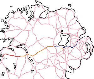
The A4 is an important road in Northern Ireland. It runs from east to west. This road is about 69.2 miles long. It connects the towns of Portadown and Belcoo. The A4 passes through three counties: County Armagh, County Tyrone, and County Fermanagh.
Even though it was once one long road, the A4 is now in two separate parts. The first part starts in Portadown. It branches off from the A3 road. This section then meets the M1 at Junction 12.
The second part of the A4 starts near Dungannon. It begins where the M1 motorway ends, at Junction 15. From here, the A4 continues all the way to Belcoo. Belcoo is a village right on the border with the Republic of Ireland. At the border, the A4 connects to the N16 which goes to Sligo. The A4 is a main road for its entire length.
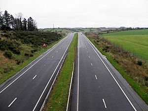
Most of the A4 is a single carriageway. This means it has one lane for traffic going in each direction. However, there is a special 13-mile section. This part, from Moygashel to Ballygawley, is a dual carriageway. A dual carriageway has two lanes for traffic in each direction, separated by a barrier. In some places, especially in Counties Tyrone and Fermanagh, the A4 also has extra lanes for overtaking.
Contents
Where Does the A4 Road Go?
The A4 road starts in Portadown. It begins near the town centre. Here, it meets the A3 and the B77 road. The A4 then goes through the suburbs of Portadown. It passes along Corcrain Road and Charles Street. It also meets the B28 road at a roundabout. This B28 road goes towards Moy.
The A4 continues as a short section called Dungannon Road. This part leads to Junction 12 of the M1. This junction is located at a place called The Birches.
The A4 then starts again where the M1 motorway finishes. This is at the junction with the A29. In the past, drivers had to go through Dungannon town centre to continue on the A4. But in 1980, a new bypass was built. This bypass allows the A4 to go around Dungannon. It includes a short section of dual carriageway.
This dual carriageway section of the A4 continues. It goes around small places like Granville, Cabragh, and Ballyreagh. It also bypasses the village of Ballygawley. At the Ballygawley Roundabout, the dual carriageway ends. Here, the A4 meets the A5.
After this, the A4 becomes a single carriageway again. It travels through the Clogher Valley. This valley has villages like Augher (where it meets the A28), Clogher, and Fivemiletown. The road then crosses into County Fermanagh. It goes past villages such as Brookeborough, Maguiresbridge (meeting the A34), Lisbellaw, and Tamlaght. These villages were bypassed in the 1960s. Since then, the A4 between Ballygawley and Enniskillen has gained many climbing and overtaking lanes. These lanes help traffic flow better.
In and around Enniskillen, the A4 shares its route with the A32. The A32 comes from Omagh and goes to Florencecourt. In Enniskillen town centre, the A4 has overtaking lanes. It also crosses the River Erne near Enniskillen Castle. There are traffic lights where the A4 meets the A32 (to Omagh) and the A46 (to Belleek).
On the western side of Enniskillen, the A4 has a roundabout with the A509. This road goes to Derrylin, Cavan, and Dublin. About a mile later, there is a T-junction with the A32 (to Florencecourt).
West of Enniskillen, the A4 passes through Letterbreen and Belcoo. In Belcoo, the A4 reaches the border with the Republic of Ireland. It crosses a bridge over Lough MacNean into Blacklion. From there, it continues as the N16 towards Sligo.
How Good is the A4 Road?
The section of the A4 from Dungannon to Ballygawley was improved. This part, which is about 12.5 miles long, was upgraded to a dual carriageway. The new road opened in November 2010. It includes a safety barrier in the middle and a hard shoulder. It also has six special junctions that separate traffic going different ways.
Another part of the road, between Ballygawley and Augher, was also changed. This work started in 2008 and finished in March 2010. These improvements help make the road safer and easier to drive on.
As of 2018, there is one main improvement planned for the A4. This is a bypass for the town of Enniskillen. A bypass is a road built around a town to avoid traffic going through the centre. This new road will be a single carriageway. It will also have some places where cars can overtake. It will cross the River Erne near the Killyhelvin Hotel. This will be the third road crossing of the river in Enniskillen.
There have been talks about adding more climbing or overtaking lanes. People have also asked for bypasses around villages in the Clogher Valley, like Fivemiletown. However, there are no definite plans for these improvements right now.
Tourist Attractions Along the A4
There are several interesting places to visit near the A4 road:
- The Linen Green, Dungannon
- Clogher Valley
- Marble Arch Caves
See Also
- Roads in Northern Ireland
 | Leon Lynch |
 | Milton P. Webster |
 | Ferdinand Smith |


