A730 road facts for kids
Quick facts for kids
A730 road |
||||
|---|---|---|---|---|
| Lua error in Module:Infobox_road/map at line 15: attempt to index field 'wikibase' (a nil value). | ||||

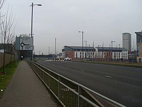
A730 New Rutherglen Road, Oatlands
|
||||
| Route information | ||||
| Length | 5.1 mi (8.2 km) | |||
| Major junctions | ||||
| Northwest end | Glasgow (Gorbals) | |||
| Southeast end | Rutherglen (Cathkin) | |||
| Highway system | ||||
Template:Infobox road/browselinks/SCT
|
||||
The A730 is a road in Scotland that connects the heart of Glasgow to the south-eastern part of the city. It stretches all the way to Cathkin, a community on the edge of Glasgow. This road helps people travel across different parts of the city and its nearby towns.
Contents
Exploring the A730 Road
Starting in Glasgow
The A730 road begins at Gorbals Cross. This is in the Laurieston area, just south of the River Clyde. It continues from a road that crosses the river on the Victoria Bridge. This bridge is near important buildings like the Glasgow Sheriff Court and Glasgow Central Mosque.
The road heads south through the Gorbals area as Gorbals Street. Here, you can see the Citizens' Theatre. For a short distance, it joins with the A728 road. They pass the old Caledonia Road Church together.
Then, the A730 turns east and becomes Caledonia Road. It goes past Hutchesontown, where you can spot some tall tower blocks. It also passes the Dixon's Blazes Industrial Estate and the Southern Necropolis.
Changes in Oatlands
When the road reaches Oatlands, it used to be a straight path called Rutherglen Road. This path went past Richmond Park. However, the area was rebuilt starting in the 2000s. Now, the road is a winding bypass called The Boulevard or Kilbride Street. This new route makes it easier to get to Junction 1A of the M74 motorway, which opened in 2011.
Reaching Rutherglen
After a junction near Shawfield Stadium, the A730 continues south. It leaves Glasgow and enters the Shawfield industrial area as Glasgow Road. This part of the road becomes a dual carriageway, meaning it has two lanes going in each direction.
It goes under the elevated M74 motorway. However, there is no direct way to get onto the motorway from here. The road then crosses over the West Coast Main Line railway tracks.
Through Rutherglen Town
Next, the A730 enters Rutherglen. It meets the town's Main Street (B768) at a crossroads. Pedestrians cannot cross directly to the Burnhill area here. Instead, they use an underpass to stay safe.
The road continues south as Mill Street. This part of the road is a bypass that was built in the 1970s and 1990s. You can still see parts of the older streets it replaced on either side.
Beyond the Town Centre
After passing a pedestrian overbridge, the road goes up a steep hill. This section goes past Overtoun Park. There are average speed cameras here to help drivers keep to the speed limit. Soon after, the road meets the B762 King's Park Avenue near Rutherglen Cemetery.
Towards Cathkin
After going under the Cathcart Circle Line railway bridge, the A730 becomes a single carriageway. It used to turn east onto Blairbeth Road, which was a narrow street. This part of the road would join the A749 (East Kilbride Road) further on.
The Cathkin Relief Road
The A730 road was changed after the Cathkin Relief Road opened in 2016. This new bypass was planned for many years. It helps to take traffic away from older, busy roads like Blairbeth Road and the Fernhill area. A new four-way junction was also added at Spittal to help with traffic flow. Blairbeth Road then became part of the B762 towards Burnside.
The Cathkin Relief Road now joins an older part of the bypass on the west side of Cathkin. It goes south of Springhall and ends where it meets the A749 at a roundabout south of Whitlawburn.
Public Transport on the A730
Several bus services use parts of the A730 road.
- The '267' bus service, run by First Glasgow, travels along most of the A730 within Glasgow.
- The '21' bus service uses almost the entire A730 route.
- In the early 1900s, Glasgow Corporation Tramways also had a tram line (the '10') that used part of this route, ending in Rutherglen.
 | Victor J. Glover |
 | Yvonne Cagle |
 | Jeanette Epps |
 | Bernard A. Harris Jr. |


