
Abuja facts for kids
Quick facts for kids
Abuja
|
|||
|---|---|---|---|
|
Federal capital city and local government area
|
|||
|
Maitama skyline
Abuja National Mosque
Zuma Rock
Fountain in Millennium Park
City Gate
Central Bank headquarters
Central Business District skyline
|
|||
|
|||
| Nickname(s):
ABJ
|
|||

Abuja
Location in Nigeria

Abuja
Location in Africa
|
|||
| Country | Nigeria | ||
| Territory | Federal Capital | ||
| Settled | 1828 | ||
| Incorporated | 1 October 1984 | ||
| Declared capital | 12 December 1991 | ||
| Named for | Abu Ja | ||
| Government | |||
| • Type | City management | ||
| • Body | Abuja Metropolitan Management Council | ||
| Area | |||
| • Federal capital city and local government area | 1,476 km2 (570 sq mi) | ||
| • Urban | 927 km2 (358 sq mi) | ||
| Elevation | 360 m (1,180 ft) | ||
| Population
(2022 estimate)
|
|||
| • Federal capital city and local government area | 1,693,400 | ||
| • Rank | 7th | ||
| • Density | 1,147.3/km2 (2,971.5/sq mi) | ||
| • Urban | 3,770,000 | ||
| • Urban density | 4,066/km2 (10,530/sq mi) | ||
| • Metro | 6,000,000 (estimated) | ||
| Time zone | UTC+01:00 (WAT) | ||
| Postal codes |
900211–900288
|
||
| Climate | Aw | ||


Abuja is the capital city of Nigeria and its sixth largest city. It is located in the middle of the country, in the Federal Capital Territory (FCT). Abuja is a planned city that was mostly built in the 1980s. It was designed by a group of American planning and architecture companies. The city's main business area was designed by Japanese architect Kenzo Tange. Abuja became Nigeria's capital on December 12, 1991, taking over from Lagos.
The city's landscape is shaped by Aso Rock, a huge rock that is about 400 meters (1,300 feet) tall. Important buildings like the Presidential Complex, National Assembly, and Supreme Court are located south of this rock. Another large rock, Zuma Rock, which is 792 meters (2,598 feet) tall, is just north of the city.
In 2006, Abuja had a population of 776,298 people. It has grown very quickly, becoming one of the fastest-growing cities in the world. By 2016, the larger metropolitan area of Abuja was estimated to have six million people. This makes it the second most populated metropolitan area in Nigeria, after Lagos.
Important religious places in Abuja include the Nigerian National Mosque and the Nigerian National Christian Centre. The city is served by the Nnamdi Azikiwe International Airport. Abuja is special because it is one of the few capital cities in Africa that was built on purpose, and it is also known for being one of the wealthiest.
Abuja is Nigeria's main administrative and political center. It is also an important city in Africa because Nigeria plays a big role in regional affairs. Abuja often hosts international meetings, like the 2003 Commonwealth Heads of Government meeting. In 2016, Abuja joined the UNESCO Global Network of Learning Cities.
Contents
History of Abuja

The name "Abuja" was first used for a nearby town, now called Suleja, in the early 1900s. The original people living in the Abuja area include the Gbagyi, Gwandara, Basa, and Abawa.
Nigeria decided to move its capital from Lagos to a more central and neutral location after gaining independence. This was to ensure fairness to all major ethnic groups and to be closer to all parts of the country. The chosen spot was in the center of Nigeria, symbolizing unity.
Another reason for the move was that Lagos had become very crowded. Moving the capital to Abuja also helped to spread economic development to other parts of Nigeria. This idea was similar to how Brazil planned its capital, Brasília.
The Nigerian government officially decided to move the capital from Lagos to Abuja on February 4, 1976. Construction began in 1979. However, due to economic and political challenges, the first parts of the city were not finished until the late 1980s. The capital officially moved to Abuja on December 12, 1991.
An American group of companies called International Planning Associates (IPA) was hired in 1977 to create the master plan for Abuja. This plan laid out the city's overall structure and main design. The detailed design of the central areas, including the important government buildings, was done by Japanese architect Kenzo Tange and his team.
Many countries have moved their embassies to Abuja. Abuja is also the headquarters for the Economic Community of West African States and the regional headquarters for OPEC. The city and the Federal Capital Territory have seen huge population growth, with some areas growing very rapidly each year.
How Abuja is Managed


The Abuja Municipal Area Council (AMAC) is the local government that manages the city of Abuja. It works under the Federal Capital Territory Administration (FCTA), which is in charge of the entire Federal Capital Territory (FCT). The FCTA is led by the Minister of the FCT, Nyesom Wike.
City Layout: Phases and Districts
To make development easier, Abuja was divided into 'Phases'. The city grows outwards from the center. Phase 1 is the core, with inner districts like Central Area, Maitama, and Garki. Phase 5 is the newest and farthest out, covering areas near the airport.
Each Phase is separated by an expressway. For example, the Nnamdi Azikiwe expressway separates Phase 1 and Phase 2. The city's road network is connected to the national highways, making it easy to travel to nearby states.
Abuja is organized into these phases, and each phase is further divided into smaller areas called districts.
Phase 1 Districts
Phase 1 contains the oldest and most central parts of Abuja.
Asokoro District
Asokoro is one of the most exclusive districts in Abuja. It is home to many government guest houses and most of the foreign embassies. The Presidential Palace, also known as Aso Rock, is located here. This makes Asokoro a very secure part of the city.
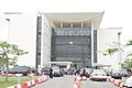
Central Business District
Abuja's Central District is the main business area. It stretches from Aso Rock in the east to the National Stadium in the west. This district divides the city into northern and southern parts. Most government offices and large companies have their offices here.
A special part of the Central District is the Three Arms Zone. This area houses the offices for the executive, legislative, and judicial branches of the government. Other important places include Eagle Square, where presidential inaugurations happen, and the Tomb of the Unknown Soldier. The National Mosque and National Church of Nigeria are also located opposite each other in this district.
Garki District
The Garki District is in the southwest of the city. It is divided into "Areas" from 1 to 11. Garki is currently a major business and administrative area of Abuja.
Many important buildings are in Garki, such as the General Post Office, Abuja International Conference Centre, and several hotels. Area 2 is mostly for homes, but it also has a small shopping center and a zoo. The headquarters of the Nigerian Armed Forces are in Garki. The tallest building in this district is the Radio House.
Maitama District

Maitama District is in the northern part of the city. It is known for being a very exclusive and expensive area, where many wealthy people and businesses are located. Important buildings include the Transcorp Hilton Abuja hotel and many embassies, like the British High Commission.
Maitama II
Maitama II District is a new area created in 2018. It is being developed from the Mpape Hills area. This district is planned to be a high-end residential area, attracting real estate investors. The government is working on building the necessary infrastructure for this new district.
Wuse District
Wuse District is in the northwestern part of Abuja. It is divided into Zones 1 to 6. The Wuse Market is the main market in the city. This district also has the Sheraton Hotel and Towers, the headquarters of the Federal Road Safety Corps, and the Wuse General Hospital. Like Garki, Wuse also has a "Wuse II" area, which is different from Wuse Zone 2. This area mainly features office buildings, large houses, and apartment blocks.
Phase 2 Districts
- Apo-Dutse
- Dakibiyu
- Duboyi
- Durumi
- Gaduwa
- Gudu
- Jabi
- Jahi
- Kado
- Katampe
- Kaura
- Kukwuaba
- Mabushi
- Utako
- Wuye
Phase 3 Districts
- Galadimawa
- Gwarimpa
- Kabusa
- Karmo
- Kafe
- Life Camp
- Nbora
- Dakwo
- Lokogoma
Phase 4 Districts
- Idu
- Karsana
There are also five suburban districts: Nyanya, Karu, Gwagwalada, Kubwa, and Jukwoyi. Along the Airport Road, there are smaller towns like Lugbe, Chika, and Mpape.
City Sights

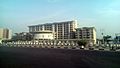
The skyline of Abuja has many modern buildings, mostly mid-sized, but taller buildings are starting to appear. This shows that it is a new and developing city.
There are plans for very tall buildings like the Millennium Tower, which will be 170 meters (558 feet) tall. This tower is part of a large cultural complex designed by Italian architect Manfredi Nicoletti.
Famous landmarks in Abuja include the Millennium Tower, the Central Bank of Nigeria headquarters, the Nigerian Presidential Complex, the National Stadium, the National Mosque, the National Church, Aso Rock, and Zuma Rock.
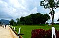
Parks and Green Spaces

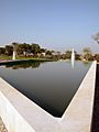
Abuja has many parks and green areas. The biggest is Millennium Park, designed by architect Manfredi Nicoletti. It was opened by Queen Elizabeth II in 2003.
Another park is in Lifecamp Gwarimpa, which has sports facilities like basketball and badminton courts. The City Park in Wuse 2 offers many outdoor and indoor activities, including a 4D cinema and various restaurants. The National Children's Park and Zoo has animals and places for recreation.

Bush Bars
Abuja also has informal places called "Bush Bars." These are usually covered areas with tables and chairs where people can relax, have drinks, and buy snacks like suya (grilled meat) or grilled catfish. You can find them all over the city.
Geography and Climate
Abuja is located at an elevation of 360 meters (1,180 feet).
Climate
Abuja has a tropical wet and dry climate. The city experiences three main weather conditions each year: a warm, humid rainy season, a very hot dry season, and a short period called harmattan. During harmattan, there is a lot of dust haze and clear skies.
The rainy season lasts from April to October. During this time, daytime temperatures are around 28°C to 30°C (82°F to 86°F), and nighttime temperatures are about 22°C to 23°C (72°F to 73°F). In the dry season, daytime temperatures can reach as high as 40°C (104°F), and overnight temperatures can drop to 20°C (68°F). Even on the coolest nights, the next day can be very hot.
The city's location and hilly land help to make the weather milder. Abuja gets a lot of rain during the rainy season because of its position near the Jos Plateau.
| Climate data for Abuja, Nigeria (1991-2020) | |||||||||||||
|---|---|---|---|---|---|---|---|---|---|---|---|---|---|
| Month | Jan | Feb | Mar | Apr | May | Jun | Jul | Aug | Sep | Oct | Nov | Dec | Year |
| Record high °C (°F) | 40.0 (104.0) |
42.0 (107.6) |
42.0 (107.6) |
41.0 (105.8) |
39.7 (103.5) |
37.8 (100.0) |
34.7 (94.5) |
33.5 (92.3) |
34.0 (93.2) |
40.0 (104.0) |
38.1 (100.6) |
39.0 (102.2) |
42.0 (107.6) |
| Mean daily maximum °C (°F) | 35.2 (95.4) |
36.9 (98.4) |
37.3 (99.1) |
35.6 (96.1) |
32.9 (91.2) |
30.8 (87.4) |
29.5 (85.1) |
28.7 (83.7) |
29.9 (85.8) |
31.3 (88.3) |
34.2 (93.6) |
35.0 (95.0) |
33.1 (91.6) |
| Daily mean °C (°F) | 26.9 (80.4) |
29.3 (84.7) |
30.7 (87.3) |
30.0 (86.0) |
28.1 (82.6) |
26.6 (79.9) |
25.7 (78.3) |
25.2 (77.4) |
25.7 (78.3) |
26.5 (79.7) |
26.9 (80.4) |
26.3 (79.3) |
27.3 (81.1) |
| Mean daily minimum °C (°F) | 18.5 (65.3) |
21.6 (70.9) |
24.1 (75.4) |
24.4 (75.9) |
23.3 (73.9) |
22.3 (72.1) |
22.0 (71.6) |
21.8 (71.2) |
21.6 (70.9) |
21.6 (70.9) |
19.7 (67.5) |
17.7 (63.9) |
21.5 (70.7) |
| Record low °C (°F) | 11.0 (51.8) |
13.7 (56.7) |
15.0 (59.0) |
14.0 (57.2) |
15.0 (59.0) |
17.2 (63.0) |
16.0 (60.8) |
15.0 (59.0) |
18.0 (64.4) |
16.5 (61.7) |
13.0 (55.4) |
8.9 (48.0) |
8.9 (48.0) |
| Average precipitation mm (inches) | 0.8 (0.03) |
5.9 (0.23) |
22.4 (0.88) |
72.8 (2.87) |
156.7 (6.17) |
194.4 (7.65) |
249.8 (9.83) |
308.3 (12.14) |
229.4 (9.03) |
169.5 (6.67) |
9.7 (0.38) |
1.3 (0.05) |
1,421.1 (55.95) |
| Average precipitation days (≥ 1 mm) | 0.1 | 0.4 | 1.9 | 6.0 | 11.3 | 12.2 | 15.0 | 17.3 | 16.0 | 13.0 | 0.9 | 0.0 | 94.0 |
| Average relative humidity (%) | 44.4 | 44.9 | 56.1 | 71.5 | 80.9 | 84.7 | 86.8 | 88.0 | 86.8 | 83.4 | 65.8 | 50.9 | 70.3 |
| Source: NOAA | |||||||||||||
Vegetation
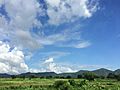
Abuja is in a zone where forests and savannas meet. Some parts of the territory, especially in the hilly southeastern areas, still have patches of mature rain forest. These are some of the few remaining natural forests in Nigeria.
Population and Growth
In 2006, Abuja city had a population of 776,298. The United Nations reported that Abuja grew by almost 140% between 2000 and 2010, making it the fastest-growing city in the world. As of 2015, it continues to grow very quickly, at least 35% each year.
Surrounding Areas
Abuja has seen a large number of people moving into the city. This growth has led to the development of satellite towns around it, such as Karu Urban Area, Suleja, Gwagwalada, and Kubwa. The larger metropolitan area of Abuja was estimated to have six million people in 2016, making it Nigeria's second-largest metro area. The city also has a growing community of immigrants, mainly from other West African countries.
Economy and Transportation
Real Estate
Real estate is a very important part of Abuja's economy. The city has seen a lot of growth and investment in buildings and properties. This investment comes from both foreign and local sources. The real estate sector also creates many jobs in the city.
Annual Trade Fair
The Abuja International Trade Fair (AITF) has been held every year since 2005. It is organized by the Abuja Chamber of Commerce and Industry (ACCI) to help businesses connect and trade.
Transportation
Airport
Nnamdi Azikiwe International Airport is the main airport for Abuja. It is named after Nigeria's first president. The airport has terminals for both international and domestic flights.

Highways
Abuja is connected to other parts of Nigeria by major highways. The A234 Federal Highway starts in Abuja and links to states like Nasarawa and Plateau. The A2 expressway connects Abuja to Kaduna in the north and Lokoja in the south. There are also other roads that link the city to its surrounding areas.


Rail
Abuja is part of the planned Lagos–Kano Standard Gauge Railway. The section between Abuja and Kaduna is already finished. Trains to Kaduna leave from the Idu Railway Station in Abuja.
Abuja light rail started operating in 2018, becoming the first rapid transit system in West Africa. It was temporarily closed in 2020 due to the COVID-19 pandemic but reopened on May 29, 2024.


Education in Abuja
Abuja is becoming a popular place for students because it has many good universities, both public and private.
Universities
- African University of Science and Technology
- Baze University
- National Open University of Nigeria
- Nile University of Nigeria
- University of Abuja
- Veritas University
- Philomath University
International Schools
- American International School of Abuja
- Whiteplains British School, Jabi
- École Française Marcel Pagnol
Natural Resources
Abuja is rich in natural resources. These resources are used as raw materials for different industries, including pharmaceuticals, food processing, and medicine. They are also important for trade and as sources of food.
Mineral Raw Materials
Honorary Citizens
People who have been given Honorary citizenship of Abuja include:
| Date | Name | Notes |
|---|---|---|
| 10 February 2016 | Joachim Gauck | President of Germany(2012–2017) |
| 4 July 2018 | Emmanuel Macron | President of France (2017–). |
| 30 August 2018 | Rt. Hon. Theresa May | Prime Minister of the United Kingdom (2016–2019). |
Images for kids
-
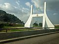
Abuja city gate
-
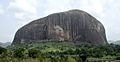
Zuma rock
-
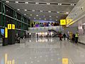
Terminal at the Abuja International Airport
-
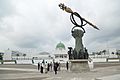
Nigeria's National Assembly Building with the Mace
-
The Ministry of Foreign Affairs
-

Shehu Musa Yar'adua Center
-
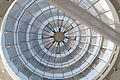
Glass Dome of Shehu Musa Yar'adua Centre in Abuja
-

Side view of Central Bank of Nigeria, Abuja
-
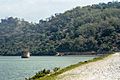
Usman Dam, Bwari Abuja
-
Usuma Dam Abuja
-
Nigeria Senate Building (Red Chamber)
-
Millennium Park
-
Abuja Millennium Park
-
Green hills
-
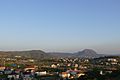
View of Abuja from Katampe hill
-
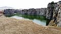
Crush Rock Abuja Nigeria


.jpg)


See also
 In Spanish: Abuya para niños
