Acandí facts for kids
Quick facts for kids
Acandí
|
|||
|---|---|---|---|
|
Municipality and town
|
|||
 |
|||
|
|||

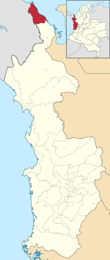
Location of the municipality and town of Acandí in the Chocó Department of Colombia.
|
|||
| Country | |||
| Department | Chocó Department | ||
| Area | |||
| • Total | 869 km2 (336 sq mi) | ||
| Population
(Census 2018)
|
|||
| • Total | 12,095 | ||
| • Density | 13.918/km2 (36.048/sq mi) | ||
| Time zone | UTC-5 (Colombia Standard Time) | ||
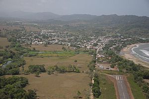
Acandí is a town in Colombia. It is located at the very northern tip of the Chocó region. This area is in the northwest of Colombia, right next to Panama and the Caribbean Sea.
Acandí is about 366 kilometers (227 miles) from Quibdó, which is the capital city of the Chocó department. The weather in Acandí is usually warm, with an average temperature of 28°C (82°F). The town was started around 1887. It became its own official municipality in 1905. Before that, it was part of a nearby town called Turbo. The name "Acandí" comes from an old local word, "Acanti," which means "River of Stone."
Acandí is part of a larger area called the region of Darién. Other towns in this region include Unguía, Juradó, and Riosucio. These towns are all west of the Atrato river.
It's interesting that Acandí doesn't have any roads connecting it to other places. It's only about 8 kilometers (5 miles) from the border with Panama. To get there, people often use a ferry that crosses the Gulf of Urabá to Necoclí. From Necoclí, there's a paved road that goes south. This ferry is how most things arrive in Acandí if they don't come by air. In recent years, these ferries have been very busy, often carrying many people traveling towards the United States.
Contents
History of Acandí
The name Acandí comes from the Acandí tribe. It means "River of Stones." The first town of Acandí was founded around 1890 by Spanish settlers. Some of these settlers were Concepción Gómez, Fermín Ávila, José Piestán, and José Garrido. They first named the town San Nicolás de Titumate.
The first location was on the western side of the Acandí River. However, the river often flooded and damaged the town. So, in 1896, the people moved the village to its current, safer spot. Acandí officially became a municipality on August 5, 1908.
Where is Acandí?
Acandí's main town area is right by the Caribbean Sea. It's in the northeastern part of the Gulf of Urabá. The town is about 558 kilometers (347 miles) from Quibdó, the capital of the department.
The entire municipality of Acandí covers an area of 869 square kilometers (336 square miles). To the north, it borders the Caribbean Sea. To the south, it borders the municipality of Unguía. And to the west, it shares a border with the Republic of Panama.
Acandí's Climate
Acandí has a very wet tropical rainforest climate. This type of climate means it's hot and rainy all year round.
| Climate data for Acandí | |||||||||||||
|---|---|---|---|---|---|---|---|---|---|---|---|---|---|
| Month | Jan | Feb | Mar | Apr | May | Jun | Jul | Aug | Sep | Oct | Nov | Dec | Year |
| Mean daily maximum °C (°F) | 29.8 (85.6) |
30.1 (86.2) |
30.1 (86.2) |
30.2 (86.4) |
30.1 (86.2) |
30.0 (86.0) |
29.8 (85.6) |
29.6 (85.3) |
29.7 (85.5) |
29.3 (84.7) |
29.3 (84.7) |
29.9 (85.8) |
29.8 (85.7) |
| Daily mean °C (°F) | 26.0 (78.8) |
26.2 (79.2) |
26.5 (79.7) |
26.6 (79.9) |
26.4 (79.5) |
26.3 (79.3) |
26.2 (79.2) |
26.0 (78.8) |
25.9 (78.6) |
25.8 (78.4) |
25.8 (78.4) |
25.9 (78.6) |
26.1 (79.0) |
| Mean daily minimum °C (°F) | 22.3 (72.1) |
22.3 (72.1) |
22.9 (73.2) |
23.0 (73.4) |
22.8 (73.0) |
22.6 (72.7) |
22.7 (72.9) |
22.4 (72.3) |
22.1 (71.8) |
22.3 (72.1) |
22.4 (72.3) |
22.0 (71.6) |
22.5 (72.5) |
| Average rainfall mm (inches) | 131.9 (5.19) |
84.1 (3.31) |
119.8 (4.72) |
287.1 (11.30) |
376.4 (14.82) |
268.3 (10.56) |
296.1 (11.66) |
283.3 (11.15) |
201.0 (7.91) |
226.7 (8.93) |
268.6 (10.57) |
281.5 (11.08) |
2,824.8 (111.2) |
| Average rainy days | 9 | 7 | 8 | 14 | 18 | 17 | 18 | 17 | 14 | 15 | 16 | 14 | 167 |
| Source: Instituto de Hidrología, Meteorología y Estudios Ambientales | |||||||||||||
What People Do for Work
The main ways people make a living in Acandí are:
- Agriculture: Growing crops like maize (corn), plantains, and yuca (cassava).
- Livestock raising: Farming animals.
- Artisan fishing: Fishing in traditional ways.
- Informal commerce: Buying and selling goods, often in small, unofficial businesses.
Acandí also includes a popular place for tourists called Capurganá. This area is very close to the border with Panama.
How to Get Around
Acandí has a small seaport on the Caribbean Sea. This port is mainly used to connect with other nearby ports in Colombia and Panama. The Atrato River is also used for transportation. It's a way to reach the department's capital, Quibdó.
The town also has a small airport called Alcides Fernández Airport. It's a Class G airport with a runway that is 1,200 meters (about 3,900 feet) long and 10 meters (about 33 feet) wide. This airport can handle light planes. It's mostly used for flights to Quibdó or to towns in the Antioquia Department. The Colombian government agency INCORA owns this airport.
People in Acandí can also use two other small airfields nearby in Capurganá:
- Capurganá Airport: This is a Class F airport. Its runway is 852 meters (about 2,795 feet) long and 12 meters (about 39 feet) wide. The municipality operates it.
- El Gilcal Airport: This is a Class G airport. It has a runway that is 500 meters (about 1,640 feet) long and 15 meters (about 49 feet) wide. The municipality also owns this one.
See also
 In Spanish: Acandí para niños
 | George Robert Carruthers |
 | Patricia Bath |
 | Jan Ernst Matzeliger |
 | Alexander Miles |


