Adair, Iowa facts for kids
Quick facts for kids
Adair, Iowa
|
|
|---|---|

Water Tower (2018)
|
|

Location in the State of Iowa
|
|
| Country | |
| State | |
| Counties | Adair, Guthrie |
| Incorporated | August 20, 1872 |
| Area | |
| • Total | 2.23 sq mi (5.78 km2) |
| • Land | 2.21 sq mi (5.74 km2) |
| • Water | 0.02 sq mi (0.04 km2) |
| Elevation | 1,467 ft (447 m) |
| Population
(2020)
|
|
| • Total | 791 |
| • Density | 357.11/sq mi (137.89/km2) |
| Time zone | UTC-6 (CST) |
| • Summer (DST) | UTC-5 (CDT) |
| ZIP code |
50002
|
| Area code(s) | 641 |
| FIPS code | 19-00370 |
| GNIS feature ID | 2393880 |
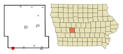
Adair is a small city located in Iowa, a state in the United States. It's special because it sits across two counties: Adair County and Guthrie County. In 2020, about 791 people lived there.
History of Adair
The city of Adair started to grow around 1868. This was when the Rock Island Railroad built its tracks through the area. People first called the spot "Summit Cut." This name came from a ridge that divides the water flowing towards the Missouri River and the Mississippi River.
Adair officially became a city on August 20, 1872. It was named after John Adair, a general from the War of 1812. He later became the eighth governor of Kentucky.
Adair is also known for a famous event in the American West. On July 21, 1873, the James-Younger Gang, led by Jesse James, robbed a train near the town. They took about $3,000 after derailing the Rock Island Express train. Sadly, the train's engineer was killed during this event.
A very strong tornado hit near Adair on June 27, 1953. It was an F5 tornado, which is the strongest type. Most of the damage happened closer to the town of Anita. One person died, and two others were hurt.
If you drive on Interstate 80, you might spot Adair's tall yellow water tower. It has a big smiley face painted on it! The road sign welcoming visitors says, "Welcome to Adair; it'll make you smile." Some local businesses even use the smiley-face tower in their logos.
The city of Adair is also mentioned in the 2013 novel Doctor Sleep by famous author Stephen King.
Geography of Adair
Adair is located at 41°30′0″N 94°38′38″W / 41.50000°N 94.64389°W.
The city covers a total area of about 2.22 square miles (5.78 square kilometers). Most of this area, about 2.20 square miles (5.74 square kilometers), is land. A small part, about 0.02 square miles (0.04 square kilometers), is water.
Population and People
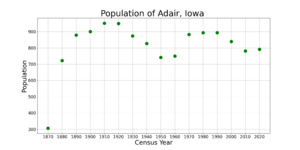
| Historical population | ||
|---|---|---|
| Year | Pop. | ±% |
| 1870 | 306 | — |
| 1880 | 722 | +135.9% |
| 1890 | 879 | +21.7% |
| 1900 | 900 | +2.4% |
| 1910 | 952 | +5.8% |
| 1920 | 950 | −0.2% |
| 1930 | 874 | −8.0% |
| 1940 | 827 | −5.4% |
| 1950 | 742 | −10.3% |
| 1960 | 750 | +1.1% |
| 1970 | 883 | +17.7% |
| 1980 | 894 | +1.2% |
| 1990 | 894 | +0.0% |
| 2000 | 839 | −6.2% |
| 2010 | 781 | −6.9% |
| 2020 | 791 | +1.3% |
| Total Population for Iowa's Incorporated Places: 1850-2000 Source: |
||
According to the 2020 census, 791 people lived in Adair. The city had 361 households and 217 families. The population density was about 357 people per square mile (137.9 people per square kilometer).
The median age in Adair was 43.8 years. This means half the people were older than 43.8, and half were younger. About 22.6% of the residents were under 20 years old. Also, 19.7% of the people were 65 years old or older. The population was almost evenly split between males (49.7%) and females (50.3%).
Education in Adair
Adair is part of the Adair–Casey Community School District. The city has Adair–Casey Elementary School and AC/GC Junior High School. For high school, students go to AC/GC High School in Guthrie Center. This is part of a special arrangement with the Guthrie Center Community School District.
See also
 In Spanish: Adair (Iowa) para niños
 | John T. Biggers |
 | Thomas Blackshear |
 | Mark Bradford |
 | Beverly Buchanan |


