
Adair Village, Oregon facts for kids
Quick facts for kids
Adair Village, Oregon
|
|
|---|---|

Location in Oregon
|
|
| Country | United States |
| State | Oregon |
| County | Benton |
| Incorporated | 1976 |
| Area | |
| • Total | 0.44 sq mi (1.15 km2) |
| • Land | 0.44 sq mi (1.15 km2) |
| • Water | 0.00 sq mi (0.00 km2) |
| Elevation | 322 ft (98 m) |
| Population
(2020)
|
|
| • Total | 1,018 |
| • Density | 2,238.74/sq mi (863.42/km2) |
| Time zone | UTC-8 (Pacific) |
| • Summer (DST) | UTC-7 (Pacific) |
| ZIP code |
97330
|
| Area codes | 458 and 541 |
| FIPS code | 41-00275 |
| GNIS feature ID | 2409661 |
Adair Village is a small city in Benton County, Oregon, United States. In 2023, about 1,018 people lived there. It's a quiet place with a unique history.
Contents
History of Adair Village
Adair Village got its name from a big military base called Camp Adair. This base was very important during World War II. After the war ended, most of the buildings at Camp Adair were taken down.
From Military Base to University Housing
However, the hospital building stayed. In 1946, Oregon State University rented it. They turned the hospital into apartments for students and teachers. This is how Adair Village started to become a community. A local government was set up, and a post office opened in 1947.
Air Force Station and City Incorporation
After a few years, fewer students needed housing. So, Oregon State University stopped renting the land. The United States Air Force then used the base as a radar station. The Adair Village post office closed in 1951. A new post office, called Adair Air Force Station, opened from 1961 to 1969.
When the Air Force left, the property was sold. The houses were then sold to individual families. In 1976, Adair Village officially became an incorporated city. This means it got its own local government. The city hall of Adair Village is actually one of the original buildings from World War II.
Geography of Adair Village
Adair Village is a small city. According to the United States Census Bureau, it covers about 0.44 square miles (1.15 square kilometers). All of this area is land.
Population and People in Adair Village
| Historical population | |||
|---|---|---|---|
| Census | Pop. | %± | |
| 1980 | 589 | — | |
| 1990 | 554 | −5.9% | |
| 2000 | 536 | −3.2% | |
| 2010 | 840 | 56.7% | |
| 2020 | 994 | 18.3% | |
| U.S. Decennial Census | |||
Adair Village is part of the larger Corvallis, Oregon, area. This means it's connected to the economy and community of Corvallis.
People Living in Adair Village (2010)
In 2010, there were 840 people living in Adair Village. These people lived in 279 households. Most households (227) were families. The average household had about 3 people.
Many households (57%) had children under 18 living with them. About 57.7% of households were married couples. The average age of people in the city was about 30.6 years old. A large portion of the residents, 36.7%, were under 18 years old.
Sites of Interest Near Adair Village
The E. E. Wilson Wildlife Area is a special place managed by the Oregon Department of Fish and Wildlife. It is located right along the northern edge of Adair Village. This area is great for enjoying nature and seeing local wildlife.
Images for kids
-
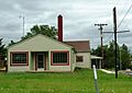
A building in Adair Village
-
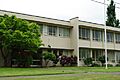
Santiam Christian Schools in Adair Village


See also
 In Spanish: Adair Village para niños
