
Affeltrangen facts for kids
Quick facts for kids
Affeltrangen
|
||
|---|---|---|
|
Municipality
|
||
 |
||
|
||

Affeltrangen
Location in Switzerland

Affeltrangen
Location in Canton of Thurgau
|
||
| Country | Switzerland | |
| Canton | Thurgau | |
| District | Münchwilen | |
| Area
Lua error in Module:Wd at line 1575: attempt to index field 'wikibase' (a nil value).
|
||
| • Total | Lua error in Module:Wd at line 1,575: attempt to index field 'wikibase' (a nil value). km2 (Formatting error: invalid input when rounding sq mi) | |
| Elevation | 489 m (1,604 ft) | |
| Population
(2018-12-31)Lua error in Module:Wd at line 1575: attempt to index field 'wikibase' (a nil value).
|
||
| • Total | Lua error in Module:Wd at line 1,575: attempt to index field 'wikibase' (a nil value). | |
| Time zone | UTC+01:00 (Central European Time) | |
| • Summer (DST) | UTC+02:00 (Central European Summer Time) | |
| Postal code(s) |
9556
|
|
| SFOS number | Lua error in Module:Wd at line 1575: attempt to index field 'wikibase' (a nil value). | |
| Localities | Affeltrangen, Azenwilen, Battlehausen, Bohl, Bollsteg, Breite, Buch bei Märwil, Ghürst, Himmenreich, Isenegg, Kaltenbrunnen, Kreuzegg, Langnau, Maltbach, Märwil, Nägelishub, Rüti, Zezikon | |
| Surrounded by | Amlikon-Bissegg, Braunau, Bussnang, Lommis, Thundorf, Tobel-Tägerschen | |
| Website | SFSO statistics |
|

Affeltrangen is a town in Switzerland. It's located in the Thurgau canton, which is like a state. It's also part of the Münchwilen district.
Contents
A Look Back: Affeltrangen's History
Affeltrangen was first mentioned way back in the year 779. Back then, it was called Affaltrawangas. Many centuries ago, important groups like the Abbey of St. Gall owned land here. Later, a group called the Commandry of Tobel took over the whole village. This was around the year 1228. In 1995, Affeltrangen joined together with three nearby villages: Buch bei Märwil, Märwil, and Zezikon. This made the municipality bigger.
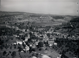
Geography: Where is Affeltrangen?
Affeltrangen covers an area of about 14.42 square kilometers (about 5.57 square miles). Most of this land, about 73.4%, is used for farming. Forests cover about 15.6% of the area. About 9.2% of the land has buildings or roads. A small part, 0.6%, is rivers or lakes. The town is located in the upper part of the Lauchetal (Lauch Valley). It includes the main village of Affeltrangen and other smaller areas. These include Bollsteg, Isenegg, Kreuzegg, Nägelishub, and Rüti.
Who Lives in Affeltrangen?
As of 2022, Affeltrangen has a population of about 2,600 people. About 11.8% of the people living here are from other countries. Most people in Affeltrangen speak German, which is 91.8% of the population. The next most common languages are Italian (2.5%) and Albanian (1.9%).
Age Groups in Affeltrangen
In 2009, here's how the population was divided by age:
- Children (0-9 years old): 11.5%
- Teenagers (10-19 years old): 13.2%
- Young adults (20-29 years old): 13.6%
- Adults (30-59 years old): 44%
- Seniors (60 years and older): 18.4%
Homes and Families
In 2000, there were 789 homes in Affeltrangen. On average, about 2.7 people lived in each home. Most homes were single-family houses (81.4%). About 61.5% of people lived in homes with a couple and children. Around 20% of people lived in homes with a couple but no children. About 5.3% of people lived in single-parent homes.
Population Changes Over Time
The number of people living in Affeltrangen has changed over the years:
| Year | Population |
|---|---|
| 1850 | 1,505 |
| 1880 | 1,228 |
| 1900 | 1,133 |
| 1950 | 1,484 |
| 1990 | 1,834 |
| 2000 | 2,135 |
Economy: How People Work
In 2007, the unemployment rate in Affeltrangen was very low, at 1.37%. Many people work in different areas:
- Farming: 163 people work in agriculture.
- Industry: 405 people work in factories or making things.
- Services: 395 people work in jobs like shops, offices, or healthcare.
In 2000, about 44% of the people who lived in Affeltrangen worked outside the town. However, 364 people came into Affeltrangen for work. About 7% of workers used public transportation, and 49.1% drove their own cars to work.
Religion
Based on the 2000 census:
- About 35.8% of people were Roman Catholic.
- About 46.1% belonged to the Swiss Reformed Church.
- Smaller groups included Orthodox Christians (1.78%) and other Christian churches (3.93%).
- About 3.09% of the population was Islamic.
- Around 6.46% of people did not belong to any church.
Transport: Getting Around
Affeltrangen is on the Wil–Kreuzlingen railway line. This line connects the towns of Wil and Weinfelden. The town is also served by the St. Gallen S-Bahn (a local train system) at Märwil railway station.
Weather in Affeltrangen
Affeltrangen usually has about 133 days of rain or snow each year. On average, it gets about 974 millimeters (38 inches) of rain or snow annually. The wettest month is June, with about 117 millimeters (4.6 inches) of rain. It rains for about 12.6 days in June. May has the most days with rain or snow, averaging 13.5 days. February is the driest month, with about 58 millimeters (2.3 inches) of precipitation.
Education
In Affeltrangen, about 72.5% of adults (aged 25–64) have completed higher education. This means they finished either advanced high school or went on to university or a specialized college.
See also
 In Spanish: Affeltrangen para niños
