
Agly facts for kids
Quick facts for kids Agly |
|
| River | |
 Agly river with the Canigou mountain on the back
|
|
| Country | |
|---|---|
| Region | Occitanie |
| Departments | Aude, Pyrénées-Orientales |
| Tributaries | |
| - left | Maury, Verdouble, Roboul |
| - right | Boulzane, Désix |
| Landmark | Gorges de Galamus |
| Source | to the northwest of Pech de Bugarach |
| - location | Bugarach, Aude, France |
| - elevation | 940 m (3,084 ft) |
| - coordinates | 42°52′30″N 2°23′05″E / 42.8751°N 2.3846°E |
| Mouth | Mediterranean Sea |
| - location | between Le Barcarès and Torreilles, Pyrénées-Orientales, France |
| - elevation | 0 m (0 ft) |
| - coordinates | 42°46′44″N 3°02′20″E / 42.779°N 3.0388°E |
| Length | 81.7 km (51 mi) |
| Basin | 1,055 km² (407 sq mi) |
| Discharge | for Le Barcarès |
| - average | 6.5 m³/s (230 cu ft/s) |
The Agly River (which means "Aglí" in Catalan and "Aglin" in Occitan) is a river in southern France. It flows mostly southeast through the Roussillon Plain in the Occitanie region. The Agly River eventually flows into the Mediterranean Sea.
On its journey, it passes through the Aude and Pyrénées-Orientales departments of France.
Contents
About the Agly River's Journey
The Agly River is about 81.7 km (50.8 mi) long. It starts high up at the Pass of Linas, near the Pech de Bugarach mountain. This mountain is the highest in the Corbières range. The river's source is in the Aude department, at an elevation of 940 m (3,084 ft).
After its source, the river enters the Pyrénées-Orientales department. It flows through the amazing Gorges de Galamus, which are like deep, narrow canyons. The Agly then continues its path until it reaches the Mediterranean Sea, south of a town called Barcarès.
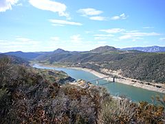
There is also a dam built on the Agly River near Caramany. This dam helps to stop floods and stores water for people to use.

How the Agly River Flows
The Agly is a small river, and its water levels can change a lot. Scientists have watched its flow for many years (from 1967 to 2008). They measured it near Estagel, about 20 kilometers from where it meets the sea.
The river's average flow, or discharge, at this spot is about 6.31 cubic meters of water per second.
Like many rivers in southern France, the Agly's flow changes with the seasons. The river has the most water in winter and spring, from December to May. February usually has the highest water levels. Then, the water level quickly drops during the drier period, which lasts from late June to early October.
Rivers Joining the Agly
The Agly River has 19 smaller rivers, called tributaries, that flow into it. Here are some of the main ones:
- Rivers joining from the right side:
- Boulzane, which is 34 km long.
- Désix, which is 32.4 km long.
- Rivers joining from the left side:
- Maury, which is 18.6 km long.
- Verdouble, which is 46.8 km long.
- Robou, which is 17.8 km long.

Towns Along the Agly River
The Agly River flows through several towns and areas. These include:
- In the Aude department: Camps-sur-l'Agly
- In the Pyrénées-Orientales department: Saint-Paul-de-Fenouillet, Ansignan, Caramany, Latour-de-France, Estagel, Cases-de-Pène, Espira-de-l'Agly, Rivesaltes, Claira, Saint-Laurent-de-la-Salanque, and Torreilles.
Cool Places to See Along the Agly
There are some interesting landmarks along the Agly River:
- Dam and Lake at Caramany: This is the dam built to control the river's flow and create a lake.
- Gorges de Galamus: These are stunning, narrow canyons carved out by the Agly River itself.
- Roman aqueduct at Ansignan: This is an ancient structure built by the Romans to carry water.
Gallery
-
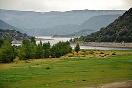
The dam on the Agly river, at Caramany
-
The lake at Caramany during a dry season
-
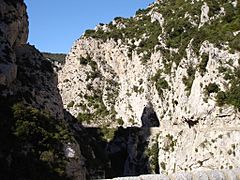
The Gorges of Galamus
-
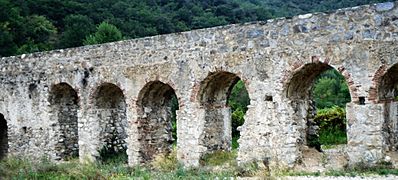
The aqueduct of Ansignan


See also
 In Spanish: Río Agly para niños
