
Agra district facts for kids
Agra district is a special area in the Uttar Pradesh state of India. The famous city of Agra, known for the Taj Mahal, is the main city and headquarters of this district. Agra district is part of a larger area called the Agra Division.
Contents
Where is Agra District?
Agra district is located in a very interesting part of India. To its north, you'll find Mathura district. To the south, it shares a border with Dholpur district in the state of Rajasthan. On the east side, it's next to Firozabad district. And to the west, it borders Bharatpur district, also in Rajasthan. The total size of Agra district is about 4,027 square kilometers.
How is Agra District Organized?
Agra district is divided into several smaller parts to help manage everything.
Tehsils and Blocks
The district has 6 main parts called tehsils. These are like smaller administrative areas. They include Etmadpur, Agra, Kiraoli, Kheragarh, Fatehabad, and Bah. The main office for the whole district is in Agra city.
Below the tehsils, there are even smaller areas called blocks. Agra district has 15 of these blocks. Some of them are Etmadpur, Khandauli, Shamshabad, Fatehabad, Jagner, Kheragarh, Saiyan, Achhnera, Akola, Bichpuri, Fatehpur Sikri, Barauli Ahir, Bah, Pinahat, and Jaitpur Kalan.
Political Divisions
For national elections, Agra district is part of 3 areas called Lok Sabha constituencies. These are Jalesar, Firozabad, and Agra. People vote in these areas to choose their representatives for the national government.
For state elections, there are 9 areas called Vidhan Sabha constituencies within the district. These include Bah, Fatehabad, Etmadpur, Dayal Bagh, Agra Cantonment, Agra East, Agra West, Kheragarh, and Fatehpur Sikri. People vote here to choose representatives for the state government.
People of Agra District
| Religions in Agra District | ||||
|---|---|---|---|---|
| Religion | Percent | |||
| Hinduism | 88.77% | |||
| Islam | 9.31% | |||
| Sikhism | 0.27% | |||
| Jainism | 0.49% | |||
| Christianity | 0.23% | |||
| Buddhism | 0.09% | |||
| Others† | 0.83% | |||
According to a survey done in 2011, Agra district had a population of about 4,380,793 people. This number is similar to the population of a country like Moldova or a US state like Kentucky. This large population makes it the 41st most populated district out of 640 districts in India.
The district is quite crowded, with about 1,084 people living in every square kilometer. Most of the people in Agra district follow Hinduism, making up about 88.77% of the population. People following Islam make up about 9.30%.
Between 2001 and 2011, the population of Agra district grew by 21%. For every 1000 boys, there were about 859 girls, which is called the sex ratio. Also, about 69.44% of the people in the district could read and write, which is known as the literacy rate.
Images for kids
-
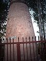
Kos Minar#793 at 12 mile on Agra-Fatehpur Sikri Road section of National Highway 21.

See Also
 In Spanish: Distrito de Agra para niños
