
Ahjumawi Lava Springs State Park facts for kids
Quick facts for kids Ahjumawi Lava Springs State Park |
|
|---|---|

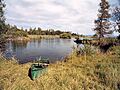
View east from the Ja-She Campground
|
|

Ahjumawi Lava Springs State Park
Location in California

Ahjumawi Lava Springs State Park
Location in the United States
|
|
| Location | Shasta County, California, USA |
| Nearest city | McArthur, California |
| Area | 5,930 acres (24.0 km2) |
| Established | 1975 |
| Governing body | California Department of Parks and Recreation |
Ahjumawi Lava Springs State Park is a special state park in California, United States. It's in a quiet, far-off part of Shasta County. You can only reach this park by boat, making it a true adventure!
The park is about 4 miles (6.4 km) long and 1 mile (1.6 km) wide. It has over 13 miles (21 km) of shoreline. This amazing place protects wild springs and cool lava flows. These lava flows formed only a few thousand years ago. The park also has beautiful waterways like the Fall River. Its shoreline has pretty blue bays and small islands with trees.
Near the springs, you can see old fish traps. These were built by Native Californian tribes like the Achomawi. The park is even named after them! They used low rock walls to create shallow pools. Here, they caught fish like sucker and trout. About two-thirds of the park's 5,930 acres (2,400 ha) is covered by rough, black basalt rock. This rock came from ancient lava flows. California bought this land from private owners in 1975.
Contents
Exploring Ahjumawi Lava Springs State Park
This park is truly unique because of its lava and water. It sits on one of the biggest systems of underwater springs in the country. These springs produce a huge amount of fresh water every day. This water comes from snowmelt high up in the Medicine Lake Volcano area.
The park is where the Modoc Plateau meets a more coastal area. The Modoc Plateau was made by volcanoes. So, the park has many cool volcanic features. These include lava tubes and craters that are now filled with spring water.
Getting to the Park
There are no public roads that lead to Ahjumawi Lava Springs State Park. You cannot drive your car inside the park. Visitors can launch their boats into Big Lake. There is a public boat launch run by Pacific Gas & Electric (PG&E). It is known as Rat Farm.
What to Do at the Park
The park has three basic campsites for visitors. You can explore the narrow waterways in a canoe or kayak. There are also about 20 miles of hiking trails. You can go Fishing in the park, but hunting is not allowed.
Native American History
The park's name honors the Achomawi people. Their name means "where the waters come together." The park is located where the Fall River meets smaller creeks and streams. The Fall River flows into the Pit River.
The Achomawi are one of eleven groups of the Pit River Tribe. These native people cared for the local waterways for a long time. They watched the fish spawning beds. They also limited how many fish they caught. This helped keep fish populations healthy for food. The Achomawi people still live in this area today.

You can still see the ancient fish traps built by the Achomawi. These traps show how clever they were. They used the natural flow of water to catch fish.
Animals and Plants
The park is home to many different plants and animals. You can find pine trees, ceanothus, and western juniper. Other trees include birchleaf and curlleaf mountain mahogany. You might also see Garry oak trees.
Many birds live in the park. These include Canada geese and snow geese. You might also spot American white pelicans and blue-winged teal. Look for Lewis's woodpeckers, northern pygmy owls, and ospreys. Other animals in the park include black-tailed deer and coyotes.
Images for kids
-
View east from the Ja-She Campground
-
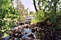
Ahjumawi fish traps showing inner chambers
