Aigremont Lake facts for kids
Quick facts for kids Aigremont Lake |
|
|---|---|

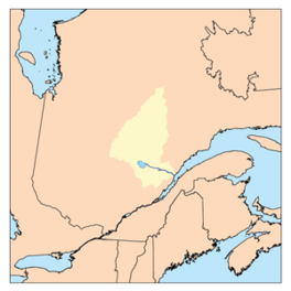
Watershed of Saguenay River
|
|
| Location | Lac-Ashuapmushuan, Quebec (non-organized territory), Le Domaine-du-Roy (RCM) |
| Coordinates | 49°18′14″N 73°49′40″W / 49.30389°N 73.82778°W |
| Type | Natural |
| Primary inflows |
|
| Primary outflows | Little Chief River. |
| Basin countries | Canada |
| Max. length | 7.7 kilometres (4.8 mi) |
| Max. width | 5.5 kilometres (3.4 mi) |
| Surface area | 9.67 kilometres (6.01 mi) |
| Surface elevation | 397 metres (1,302 ft) |
Aigremont Lake is a freshwater lake in Quebec, Canada. It is located in a wild area called Lac-Ashuapmushuan, Quebec. This area is part of the Le Domaine-du-Roy region. The lake is the starting point for the Little Chief River.
The lake is found within the Ashuapmushuan Wildlife Reserve. Its southwest shore is about 10 kilometers from the old Nicabau Railway Station. This station was part of the Canadian National Railway.
The main activity around the lake is forestry, which means cutting down trees for wood. After forestry, tourism and outdoor activities are also important.
Route 167 passes along the south side of the lake. This road connects Chibougamau to Saint-Félicien, Quebec. There is also a forest road that goes around the lake.
The surface of Aigremont Lake is usually frozen from early November to mid-May. However, it's generally safe to walk or play on the ice from mid-November to mid-April.
Contents
About Aigremont Lake
Aigremont Lake is about 7.7 kilometers long. It has a maximum width of 5.5 kilometers. The lake sits at an altitude of 397 meters above sea level.
This lake gets most of its water from five main streams. These streams bring water from eight smaller lakes nearby.
The water from Aigremont Lake flows into the Little Chief River. This river then flows north for about 4.6 kilometers. It passes through "Débâcle Lake" and "lac des Cantons".
The Little Chief River continues northeast for about 9.1 kilometers. It then joins the La Loche River.
Water Flow from the Lake
From the La Loche River, the water flows into the Ashuapmushuan River. This river then flows towards Lac Saint-Jean.
The mouth of Aigremont Lake is located:
- 9.0 km southwest of where the Little Chief River meets the La Loche River.
- 11.8 km west of where the La Loche River meets the Ashuapmushuan River.
- 13.6 km northwest of where the Normandin River meets Ashuapmushuan Lake.
- 131.3 km northwest of where the Ashuapmushuan River meets Lac Saint-Jean.
- 169.1 km west of where Lac Saint-Jean meets the Saguenay River.
Rivers Near Aigremont Lake
Here are some of the main rivers and lakes near Aigremont Lake:
- To the North: Little Chief River, Mignault Lake, Greves River, Chaudière Lake, Dobleau Lake, Vimont Lake (Lac-Ashuapmushuan).
- To the East: La Loche River, Ashuapmushuan River.
- To the South: Normandin River, Ashuapmushuan Lake, Denaut Lake, Marquette River.
- To the West: Normandin River, Bouteroue Lake, Rohault Lake.
Why the Name Aigremont?
The name "Aigremont" was officially given to the lake in 1925. It honors François Clairambault d'Aigremont (1659-1728). He was an important person in New France, which was what Canada was called long ago.
Another name for the lake is "Lac de la Cache." The name "Lake Aigremont" became official on December 5, 1968. This was when the Commission de toponymie du Québec was created.
 | Tommie Smith |
 | Simone Manuel |
 | Shani Davis |
 | Simone Biles |
 | Alice Coachman |


