Albany, Missouri facts for kids
Quick facts for kids
Albany, Missouri
|
|
|---|---|
|
City and County Seat
|
|

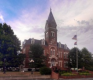
Gentry County Courthouse
|
|

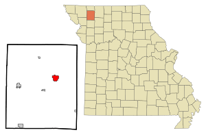
Location of Albany, Missouri
|
|
| Country | United States |
| State | Missouri |
| County | Gentry |
| Incorporated | 1845 |
| Area | |
| • Total | 2.44 sq mi (6.33 km2) |
| • Land | 2.44 sq mi (6.33 km2) |
| • Water | 0.00 sq mi (0.00 km2) |
| Elevation | 899 ft (274 m) |
| Population
(2020)
|
|
| • Total | 1,679 |
| • Density | 687.55/sq mi (265.41/km2) |
| Time zone | UTC-6 (Central (CST)) |
| • Summer (DST) | UTC-5 (CDT) |
| ZIP code |
64402
|
| Area code(s) | 660 |
| FIPS code | 29-00514 |
| GNIS feature ID | 2393899 |
| Website | albanymo.net |
Albany is a city in Missouri, USA. It is the main city and county seat of Gentry County. In 2020, about 1,679 people lived there, making it the biggest city in the county.
Contents
History of Albany
Albany was first planned as a town in 1845 and was called Athens. Later, its name was changed to Albany. This new name came from Albany, New York, which was the hometown of a local judge. A post office has been open in Albany since 1857.
Some important buildings in Albany are listed on the National Register of Historic Places. This means they are special places that are kept safe because of their history. These include the Albany Carnegie Public Library, the Gentry County Courthouse, and the Samuel and Pauline Peery House.
Geography and Location
Albany is located where two main roads meet: US Route 136 and Missouri Route 85. The city of Stanberry is about 11 miles to the west. Bethany is about 14 miles to the east in Harrison County.
Land Area
According to the United States Census Bureau, Albany covers a total area of about 2.44 square miles (6.33 square kilometers). All of this area is land.
Rivers and Creeks
Two creeks flow near Albany. Weldon Branch passes north of the town, flowing west. Town Branch crosses the southern part of Albany, also flowing west. Both creeks eventually join the East Fork of the Grand River. The East Fork of the Grand River flows south, west of Albany, and meets the Grand River about three miles south of the city.
Climate in Albany
Albany has a climate with hot, humid summers and cold winters. This type of weather is known as a humid continental climate.
| Climate data for Albany, Missouri (1991–2020 normals, extremes 1941–present) | |||||||||||||
|---|---|---|---|---|---|---|---|---|---|---|---|---|---|
| Month | Jan | Feb | Mar | Apr | May | Jun | Jul | Aug | Sep | Oct | Nov | Dec | Year |
| Record high °F (°C) | 68 (20) |
78 (26) |
85 (29) |
93 (34) |
101 (38) |
103 (39) |
109 (43) |
106 (41) |
104 (40) |
96 (36) |
80 (27) |
71 (22) |
109 (43) |
| Mean daily maximum °F (°C) | 34.7 (1.5) |
40.0 (4.4) |
52.5 (11.4) |
63.4 (17.4) |
74.0 (23.3) |
83.8 (28.8) |
88.1 (31.2) |
87.0 (30.6) |
79.4 (26.3) |
67.0 (19.4) |
52.1 (11.2) |
39.3 (4.1) |
63.4 (17.4) |
| Daily mean °F (°C) | 24.5 (−4.2) |
29.3 (−1.5) |
40.9 (4.9) |
51.5 (10.8) |
62.9 (17.2) |
73.0 (22.8) |
77.4 (25.2) |
75.4 (24.1) |
67.1 (19.5) |
54.6 (12.6) |
40.9 (4.9) |
29.7 (−1.3) |
52.3 (11.3) |
| Mean daily minimum °F (°C) | 14.4 (−9.8) |
18.7 (−7.4) |
29.3 (−1.5) |
39.6 (4.2) |
51.8 (11.0) |
62.1 (16.7) |
66.6 (19.2) |
63.8 (17.7) |
54.8 (12.7) |
42.2 (5.7) |
29.8 (−1.2) |
20.2 (−6.6) |
41.1 (5.1) |
| Record low °F (°C) | −27 (−33) |
−21 (−29) |
−23 (−31) |
10 (−12) |
27 (−3) |
35 (2) |
43 (6) |
37 (3) |
25 (−4) |
13 (−11) |
−9 (−23) |
−21 (−29) |
−27 (−33) |
| Average precipitation inches (mm) | 1.07 (27) |
1.15 (29) |
2.10 (53) |
3.64 (92) |
5.68 (144) |
5.71 (145) |
4.06 (103) |
3.95 (100) |
4.07 (103) |
2.72 (69) |
1.83 (46) |
1.50 (38) |
37.48 (952) |
| Average precipitation days (≥ 0.01 in) | 5.8 | 5.5 | 7.6 | 10.0 | 12.0 | 9.9 | 8.3 | 8.2 | 7.3 | 8.6 | 4.9 | 5.5 | 93.6 |
| Source: NOAA | |||||||||||||
Population and People
| Historical population | |||
|---|---|---|---|
| Census | Pop. | %± | |
| 1860 | 476 | — | |
| 1870 | 607 | 27.5% | |
| 1880 | 979 | 61.3% | |
| 1890 | 1,334 | 36.3% | |
| 1900 | 2,025 | 51.8% | |
| 1910 | 1,922 | −5.1% | |
| 1920 | 2,016 | 4.9% | |
| 1930 | 1,858 | −7.8% | |
| 1940 | 2,010 | 8.2% | |
| 1950 | 1,850 | −8.0% | |
| 1960 | 1,662 | −10.2% | |
| 1970 | 1,804 | 8.5% | |
| 1980 | 2,152 | 19.3% | |
| 1990 | 1,958 | −9.0% | |
| 2000 | 1,937 | −1.1% | |
| 2010 | 1,730 | −10.7% | |
| 2020 | 1,679 | −2.9% | |
| U.S. Decennial Census | |||
2010 Census Information
In 2010, the census showed that 1,730 people lived in Albany. There were 753 households, which are groups of people living together. About 446 of these were families. The city had about 709 people per square mile.
Most of the people living in Albany (98.2%) were White. A small number were African American, Native American, or Asian. About 0.6% of the population was Hispanic or Latino.
About 26.2% of households had children under 18 living with them. Many households (45.6%) were married couples. About 18.8% of households had someone living alone who was 65 years old or older. The average household had 2.21 people.
The average age of people in Albany was 44.1 years. About 21.6% of residents were under 18. About 22.9% were 65 years old or older. The city had more females (54.2%) than males (45.8%).
Education in Albany
The Albany R-III School District is in charge of the schools in the area. It operates the Virginia E. George Elementary School. It also runs Albany Middle School and Albany High School.
The town also has a public library where people can borrow books. It is called the Carnegie Library of Albany.
See also
 In Spanish: Albany (Misuri) para niños


