Andrus Island facts for kids

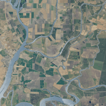
USGS aerial imagery of the island.
|
|
| Geography | |
|---|---|
| Location | Northern California |
| Coordinates | 38°09′28″N 121°35′54″W / 38.157695°N 121.598287°W |
| Adjacent bodies of water | San Joaquin River |
| Administration | |
| State | |
| County | Sacramento |
Andrus Island is an island located in the Sacramento–San Joaquin River Delta in Sacramento County, California. It is about twenty kilometers northeast of Antioch. This island covers about 3,000 hectares (or about 7,400 acres).
The island is surrounded by several waterways. The Sacramento River forms its northern and northwestern edges. To the west is Georgiana Slough, and to the southeast are the Mokelumne River and San Joaquin River. On the southwest, you'll find Jackson Slough and Seven Mile Slough.
Most of Andrus Island is used for agriculture, meaning it's a place where crops are grown. There is also a large natural gas area called the Rio Vista Gas Field on the island. However, the parts of the island used for drilling for gas are small compared to the farmland. The island's land and water systems are managed by special groups called Reclamation Districts, specifically Districts 556, 407, and 317. These districts help manage water and land use.
The city of Isleton is also located on Andrus Island.
 | George Robert Carruthers |
 | Patricia Bath |
 | Jan Ernst Matzeliger |
 | Alexander Miles |


