
Apple Creek (Mississippi River tributary) facts for kids
Quick facts for kids Apple Creek |
|
|---|---|

Apple Creek (stream) sign from Highway 61
|
|
| Country | United States |
| State | Missouri |
| Physical characteristics | |
| Main source | 820 ft (250 m) 37°38′13″N 89°58′33″W / 37.63694°N 89.97583°W |
| River mouth | Mississippi River 322 ft (98 m) 37°33′56″N 89°31′37″W / 37.56556°N 89.52694°W |
Apple Creek is a stream in Missouri, USA. It starts in western Perry County, Missouri and flows into the mighty Mississippi River. This creek also forms the border between Perry and Cape Girardeau counties.
Contents
What's in a Name?
The name Apple Creek comes from the French name Rivière à la Pomme. This means "Apple River." Long ago, the Shawnee Indians had farms and villages along this creek. They likely grew apple trees there. Early French explorers and hunters probably saw these trees. That's how they gave the creek its name. Later, Americans changed "Rivière à la Pomme" to "Apple River" or "Apple Creek."
A Look Back in Time
We don't know who lived along Apple Creek first. But over time, the Shawnee and Delaware Native American tribes made it their home. These tribes originally lived in places like Delaware and Pennsylvania. They were forced to leave their lands as more white settlers arrived.
The Spanish rulers of the area wanted the Shawnee and Delaware to move here. They gave them large areas of land along Apple Creek. The Spanish hoped these tribes would act as a barrier. They wanted protection from the Osage Indians, who were not friendly with the Spanish. About 1,200 Shawnee and 600 Delaware people agreed to move. In 1784, they settled near what is now Old Appleton. They had two main villages: the "Grand Village Sauvage" to the west and the "Petit Village Sauvage" to the east.
In the early 1800s, more American settlers started moving onto the Shawnee and Delaware lands. The Shawnee even asked the Spanish for help against the Osage in 1807. By 1815, the situation with settlers was very bad. The governor, William Clark, and President James Madison ordered settlers to leave. But this order was mostly ignored. By 1816, the U.S. government decided to move the Shawnee and Delaware tribes further west.
Where Apple Creek Flows
Apple Creek starts near Missouri Route 51. This is about five miles southwest of Perryville. The stream then flows southeast. It passes by small towns like Millheim and Biehle.
The creek then enters the northwest part of Cape Girardeau County. It winds past Friedheim. After that, it becomes the border between Cape Girardeau and Perry counties. The creek goes under I-55 and U.S. Route 61. This is south of Uniontown. Finally, it continues east and joins the Mississippi River. This meeting point is between Neely's Landing to the south and Grand Tower to the north.
Many smaller streams flow into Apple Creek. These are called tributaries. Some of them include:
- Allie Creek
- Blue Shawnee Creek
- Buckeye Creek
- Flatrock Creek
- Froggy Branch
- Gerier Lake
- Hughes Creek
- Little Apple Creek
- Indian Creek
- Rocky Branch
- Shawnee Creek
- South Fork Apple Creek
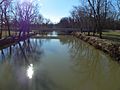
The Creek's Surroundings
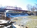
Apple Creek starts in southern Perry County. It flows east and creates the border between Perry and Cape Girardeau counties. Several bridges cross Apple Creek. These include the Apple Creek CR 630 bridge and the Apple Creek Railroad bridge. There's also the old wrought-iron Old Appleton Bridge. Another is the pony truss Old Appleton US 61 Bridge.
A town named Apple Creek is located north of the stream. This town is in Perry County, Missouri. The town of Old Appleton, Missouri, was also once called Apple Creek. It changed its name to Old Appleton before its post office opened in 1876.
Towns Along the Creek
Photo gallery
-
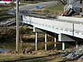
Highway 61 bridge over Apple Creek
-
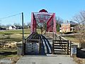
Apple Creek foot bridge
-
Highway 61 over Apple Creek
-
Apple Creek foot bridge


