
Arbury Hill facts for kids
Quick facts for kids Arbury Hill |
|
|---|---|
.JPG)
Arbury Hill from the west
|
|
| Highest point | |
| Elevation | 225 m (738 ft) |
| Listing | County top |
| Geography | |

Arbury Hill
Location in Northamptonshire
|
|
| Location | Northamptonshire, England |
| OS grid | SP540587 |
| Topo map | OS Explorer 206 |
Arbury Hill is a special place in Northamptonshire, England. It stands at 225 meters (738 feet) tall. This makes it one of the highest points in the entire county! You can find it about 9 kilometers (5.6 miles) southwest of the town of Daventry.
This hill is like a giant natural divider for water. Rain that falls on Arbury Hill flows into three different major river systems. Water goes to the River Nene (north, east, and south), the River Cherwell (south-west), and the River Leam (west and north-west). The Cherwell eventually joins the famous River Thames. The Leam flows into the River Severn. The River Nene actually starts right here, in a wet area on the hill's northwestern side. From the top, you can see far and wide. On a clear day, you might spot Rugby and Coventry to the northwest. You can also see Northampton to the east.
History of Arbury Hill
On the very top of Arbury Hill, you can find traces of an ancient fort. This fort was built a very long time ago, during the Iron Age. Experts are still trying to figure out its exact age and who built it. What's left of the fort is a square-shaped ditch and a raised bank of earth. This structure is about 200 meters (656 feet) across.
Even though not much of the fort remains today, the outer bank once surrounded an area of about 12 acres. Arbury Hill is also mentioned in old records. Back in 944 AD, King Edmund I made a land grant. He noted Arbury Hill as the spot where three local areas meet. These areas are the parishes of Badby, Dodford, and Everdon.
In 1784, Arbury Hill played a role in a big science project. It was one of many points used by the British Government. Scientists used these points to measure the Earth's exact size. This process is called triangulation. Today, there's still a special marker on the summit. It's called a Trig point, which is short for triangulation station.
Fun on the Hill
On the east side and top of Arbury Hill, there's a motor-cross track. This track is used for exciting competitions about three times a year. The ground here is mostly clay. It has steep slopes and lots of ups and downs. There are also some tricky turns and small jumps, making it a fun challenge for riders!
Gallery
-
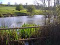
The headwater of the River Nene, on the north east slope of Arbury Hill in 2008
-
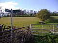
The southern side of the hill in 2008
.JPG)
.JPG)
Images for kids
-
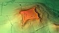
3D view of the digital terrain model

