Arenig Fawr South Top facts for kids
Quick facts for kids Arenig Fawr South Top |
|
|---|---|

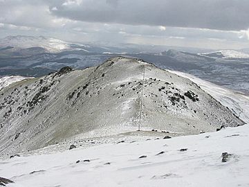
Arenig Fawr South Top from the summit of Arenig Fawr
|
|
| Highest point | |
| Elevation | 835 m (2,740 ft) |
| Prominence | 21 m (69 ft) |
| Parent peak | Arenig Fawr |
| Listing | Nuttall |
| Naming | |
| English translation | Great High Ground |
| Language of name | Welsh |
| Geography | |
| Location | Gwynedd, Wales |
| Parent range | Snowdonia |
| OS grid | SH827370 |
| Topo map | OS Landranger 124 |
Arenig Fawr South Top is a mountain peak located in the southern part of Snowdonia National Park in North Wales. It is very close to its larger neighbour, Arenig Fawr, which is why it's often called its "twin top." This peak is the second highest mountain in the Arenig mountain range.
Exploring Arenig Fawr South Top
Arenig Fawr South Top stands at 835 metres (about 2,740 feet) above sea level. This makes it a significant peak, though it is 18 metres shorter than Arenig Fawr itself. The mountain is part of the Arenig range, which is known for its rugged and wild landscapes.
What is a Nuttall?
Arenig Fawr South Top is listed as a "Nuttall." A Nuttall is a mountain in England or Wales that is at least 2,000 feet (610 metres) high. It must also have a drop of at least 15 metres (about 49 feet) on all sides. This means it stands out enough from other hills around it.
The South Ridge and Beyond
From the top of Arenig Fawr South Top, a ridge extends to the south. This area is full of interesting features. You can find rocky hills, known as knolls, and small mountain lakes called tarns. Another peak, Arenig Fawr South Ridge Top, is also located along this ridge. The views from this area are often spectacular, showing off the natural beauty of Gwynedd, Wales.
 | Percy Lavon Julian |
 | Katherine Johnson |
 | George Washington Carver |
 | Annie Easley |

