Arlington, Illinois facts for kids
Quick facts for kids
Arlington, Illinois
|
|
|---|---|

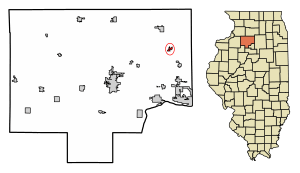
Location of Arlington in Bureau County, Illinois.
|
|

Location of Illinois in the United States
|
|
| Country | United States |
| State | Illinois |
| County | Bureau |
| Township | Westfield |
| Area | |
| • Total | 0.40 sq mi (1.02 km2) |
| • Land | 0.40 sq mi (1.02 km2) |
| • Water | 0.00 sq mi (0.00 km2) 0% |
| Population
(2020)
|
|
| • Total | 169 |
| • Density | 427.85/sq mi (165.06/km2) |
| Time zone | UTC-6 (CST) |
| • Summer (DST) | UTC-5 (CDT) |
| ZIP Code(s) |
61312
|
| Area codes | 815 & 779 |
| FIPS code | 17-02102 |
Arlington is a small village in Bureau County, Illinois, United States. In 2020, about 169 people lived there. It is part of the Ottawa area. You can find it east of the Quad Cities and southwest of Chicago.
History of Arlington
In the early 1900s, Arlington was growing fast. Back then, it was called "Lost Grove." Many businesses opened to serve people who came for jobs in the coal mines. There was a mattress factory, a beer brewery, and many restaurants. The mayor, who was from New York, changed the town's name to Arlington. He named it after a town in his home state. At that time, Arlington was as big as Peru, Illinois.
A sad event happened on November 13, 1909. A fire in the Cherry coal mine killed 259 miners. Some of them were very young. Authorities sealed the mine to stop the fire. This trapped many rescue workers inside. When the mine was opened a week later, only 20 men had survived. This event, known as the 1909 Cherry Mine disaster, led to new laws. These laws helped make working conditions safer for miners. After this disaster, Arlington's growth slowed down a lot.
In the 1950s, a tornado hit Arlington. It destroyed most of the village. Many people moved away after that. Today, Arlington has fewer than 200 people. Many old businesses and homes are now closed or gone. Some areas that used to have houses are now farm fields. You can still see old foundations in these fields.
Where is Arlington?
Arlington is located at 41°28′20″N 89°14′49″W / 41.47222°N 89.24694°W. This is its exact spot on a map.
In 2010, the village covered about 0.4 square miles (1.02 square kilometers). All of this area is land.
People in Arlington
| Historical population | |||
|---|---|---|---|
| Census | Pop. | %± | |
| 1880 | 447 | — | |
| 1890 | 436 | −2.5% | |
| 1900 | 400 | −8.3% | |
| 1910 | 370 | −7.5% | |
| 1920 | 284 | −23.2% | |
| 1930 | 258 | −9.2% | |
| 1940 | 258 | 0.0% | |
| 1950 | 247 | −4.3% | |
| 1960 | 254 | 2.8% | |
| 1970 | 250 | −1.6% | |
| 1980 | 236 | −5.6% | |
| 1990 | 200 | −15.3% | |
| 2000 | 211 | 5.5% | |
| 2010 | 193 | −8.5% | |
| 2020 | 169 | −12.4% | |
| U.S. Decennial Census | |||
In 2020, there were 169 people living in Arlington. There were 76 households and 61 families. Most people living there were White (94.67%). A small number were African American, Asian, or from two or more races. About 1.18% of the population was Hispanic or Latino.
About 27.6% of households had children under 18. Most households (68.42%) were married couples. The average household had about 3 people. The average family had about 2.78 people.
The median age in the village was 46.5 years old. This means half the people were younger and half were older. About 17.5% of the people were under 18. About 13.7% were 65 or older.
Notable people
- Mike Prendergast, a professional baseball player
- Albert B. Wolfe, an economist
See also
 In Spanish: Arlington (Illinois) para niños
 | Chris Smalls |
 | Fred Hampton |
 | Ralph Abernathy |


