Arroyo Mocho facts for kids
Quick facts for kids Arroyo Mocho |
|
|---|---|

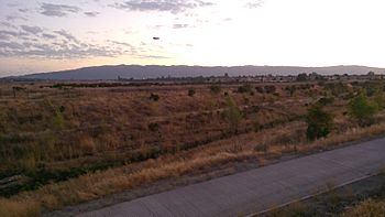
Arroyo Mocho at dusk flowing under the El Charro Rd. bridge during the East Pleasanton Specific Plan Task Force field trip. A Hangar One Vodka blimp heads for landing at nearby Livermore Airport. Pleasanton Ridge rises in the background.
|
|
|
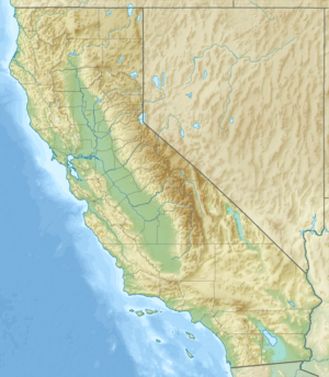
Location of the mouth of Arroyo Mocho in California
|
|
| Country | United States |
| State | California |
| Counties | Alameda County & Santa Clara County |
| Cities | Pleasanton & Livermore |
| Physical characteristics | |
| Main source | Mount Mocho 18 mi (30 km) east of Milpitas 3,160 ft (960 m) 37°27′13″N 121°31′22″W / 37.45361°N 121.52278°W |
| River mouth | Confluence with South San Ramon Creek to form Arroyo de la Laguna Pleasanton, California 315 ft (96 m) 37°40′37″N 121°54′44″W / 37.67694°N 121.91222°W |
Arroyo Mocho is a stream in California, about 34.7 miles (55.8 kilometers) long. It starts in the far northeastern part of Santa Clara County. The stream then flows northwest into Alameda County, California.
Arroyo Mocho passes through the cities of Livermore and Pleasanton. It eventually joins with South San Ramon Creek to form Arroyo de la Laguna. This larger creek then flows into Alameda Creek, which finally reaches San Francisco Bay.
Contents
What's in a Name?
The name Arroyo Mocho means "cutoff creek" in Spanish. It got this name because, a long time ago, the creek didn't have a clear path to a larger river. Instead, its water would spread out into many smaller streams between Livermore and Pleasanton and then sink into the ground.
People also called it Mocho Creek as early as 1852. There's another story about its name from a book by Frank Latta. He wrote that the name came from a man nicknamed "Mocho." This man was known for being short, and "Mocho" can mean "lopped off" or "short." He helped with moving horses along a route called La Vereda del Monte. This route passed near the creek. Both the creek and Mount Mocho were named after him.
Where Arroyo Mocho Flows
Arroyo Mocho begins on the western side of Mount Mocho, which is about 3,684 feet (1,123 meters) tall. This is in the northeast corner of Santa Clara County. From there, it flows west to Mines Road. It then follows this road northwest into Alameda County, California.
Along its path, the creek passes a place called Sweet Springs. This is a special spring known for its sweet-tasting water. In the past, the creek's water would disappear into the ground in the area between Livermore and Pleasanton. Today, this area has many gravel pits. However, engineers have built a special channel. This channel now connects Arroyo Mocho directly to Arroyo de la Laguna.
Underground Water Sources
Beneath the ground where Arroyo Mocho flows is an important underground water storage area called the Mocho Subbasin. Think of it like a giant sponge filled with water. The eastern edge of this subbasin is marked by something called the Tesla Fault. A fault is like a big crack in the Earth's crust. Some groundwater can move across this fault. However, the flow of water is not continuous below about 50 feet (15 meters) deep across the Tesla Fault. It's also not continuous south of the Arroyo Mocho channel across another crack called the Livermore Fault.
Wildlife in the Creek
Arroyo Mocho is home to a type of fish called rainbow trout (Oncorhynchus mykiss). These trout can live and reproduce in the creek on their own. They can also travel from Alameda Creek to the lower parts of Arroyo Mocho.
See Also
 | Roy Wilkins |
 | John Lewis |
 | Linda Carol Brown |


