
Artvin facts for kids
Quick facts for kids
Artvin
|
|
|---|---|

Artvin Çoruh University City Campus
|
|

Artvin
Location in Turkey
|
|
| Country | Turkey |
| Province | Artvin |
| District | Artvin |
| Elevation | 345 m (1,132 ft) |
| Population
(2021)
|
25,841 |
| Time zone | TRT (UTC+3) |
| Postal code |
08000
|
| Climate | Cfb |
Artvin is a city in northeastern Turkey. It is located about 30 kilometers (19 miles) inland from the Black Sea. Artvin is the main city of both Artvin Province and Artvin District. In 2021, its population was 25,841 people.
The city sits on a hill, offering views of the Çoruh River. It is also close to the Deriner Dam. Artvin is home to Artvin Çoruh University.

Contents
History
Ancient Times
People have lived in the Artvin area for a very long time. Scientists have found ancient tools and objects from the Bronze Age and even earlier. This region was once part of the kingdom of Colchis. It was also part of Greater Armenia. However, it was often attacked by different groups.
First, the Scythians invaded from across the Caucasus mountains. Later, Muslim armies took control from 853 AD to 1023 AD. Then, the Byzantines conquered the area.
Georgian Kingdoms
During the 7th and 8th centuries, the Principalities of Tao-Klarjeti formed in this area. These kingdoms came after the early medieval Kingdom of Iberia. They later helped unite the Georgian Kingdom. For a long time, this region was a safe place for Georgian culture. It also became an important religious center for Georgia.
Turkish and Mongol Rule
The Seljuk Turks conquered Artvin in 1064 AD. But soon after, the Georgians, with help from the Byzantines, briefly took it back. However, Turkish forces regained control in 1081. When the Seljuk Empire fell apart, the Artvin area came under the control of the Ildeniz tribe.
The Kingdom of Georgia then took back control of the region. But Georgia became weak due to Mongol invasions. This allowed Turkmen groups to start attacking southwestern Georgia. The local Georgian people asked the lord of Samtskhe for help. By the mid-13th century, the Jaqeli family ruled most of the mountainous areas of northeastern Anatolia. Different Turkmen groups fought over the area until the Safavids conquered it in 1502.
Ottoman Empire and Russia
The Ottoman Empire took control of the eastern Black Sea coast and the mountains. This happened after they defeated the Empire of Trebizond. Later, the Ottomans gained control of many castles in the district. In 1551, Ottoman rule over Artvin was made secure. The city of Batumi became an important center for the area.
This Ottoman rule lasted for 250 years. Then, the area was given to the Russians after the Russo-Turkish War (1828–1829). It was later recovered by the Ottomans but given back to Russia after the Russo-Turkish War of 1877-78. Artvin was often a war zone, changing hands between Russia and Turkey many times. This conflict caused great hardship for the people of Artvin. Many people moved away from the Russian-controlled areas.
Modern Era
The Russians left Artvin after the Russian Revolution in 1917. After World War I, British troops moved into the area in 1918. Then, the Democratic Republic of Georgia took over. Finally, Artvin became part of modern Turkey in 1921, following the Treaty of Kars.
Above the city and road is an old fortress. It was once part of the medieval Georgian district of Nigali. The fortress has a wall around the top of the hill. It also has several rooms, a protected entrance, and a large tower. There are also openings for archers to shoot from.
Demographics
In 1897, the town of Artvin was mostly home to Armenians. Many of them had moved from other regions. However, the larger district around the town was mainly Muslim. Outside the town, the population of the district was about 49,049 people. Of these, 82% were Turks, 11% were Georgians, and 6% were Armenians.
| Year | Total | Main Groups |
|---|---|---|
| 1886 | 6,442 | Armenians (76.4%), Turks (23.4%) |
| 1897 | 7,091 | Armenians (65.5%), Turks (21.0%), East Slavs (11.9%), Georgians (0.9%) |
| 1907 | 7,345 | Mostly Armenians and Turks |
| 1916 | 6,997 | Armenians (77.9%), Georgians (12.6%), North Caucasians (4.3%), Russians (3.1%), Shia Muslims (2.0%) |
| 1985 | 18,720 | Turks, Laz, Georgian |
| 1990 | 20,306 | Turks, Laz, Georgian |
| 2000 | 23,157 | Turks, Laz, Georgian |
| 2016 | 26,329 | Turks, Laz, Georgian |
Places of Interest

- Artvin or Livana (Livane) castle, built in 937 AD.
There are also several old Ottoman houses and public buildings, including:
- Salih Bey mosque, built in 1792.
- Çarsi mosque, built in the 18th century.
- Balcioglu mosque, built in the 18th century.
- The fountain of Çelebi Efendi, built in 1783.
The countryside around Artvin is great for outdoor activities. You can go climbing, trekking (long walks), and rafting on the rivers.
Events
Artvin is famous for its Caucasus (Kafkas in Turkish) Culture and Arts Festival. This celebration happens every year at the Kafkasör plateau. The most popular event is the bull wrestling. It attracts many visitors from both Turkey and other countries.
Climate
Artvin has an Oceanic climate (Cfb) according to the Köppen system. This means it has mild temperatures and rain throughout the year. It also has a warm summer oceanic climate (Dob) based on the Trewartha classification system.
- Highest temperature ever recorded: 43.0 °C (109.4 °F) on August 18, 1961.
- Lowest temperature ever recorded: -16.1 °C (3.0 °F) on January 14, 1950.
| Climate data for Artvin (normals 1991–2020, extremes 1949–2023) | |||||||||||||
|---|---|---|---|---|---|---|---|---|---|---|---|---|---|
| Month | Jan | Feb | Mar | Apr | May | Jun | Jul | Aug | Sep | Oct | Nov | Dec | Year |
| Record high °C (°F) | 18.9 (66.0) |
21.5 (70.7) |
28.4 (83.1) |
34.4 (93.9) |
36.7 (98.1) |
39.0 (102.2) |
42.0 (107.6) |
43.0 (109.4) |
41.5 (106.7) |
33.9 (93.0) |
27.9 (82.2) |
20.9 (69.6) |
43.0 (109.4) |
| Mean daily maximum °C (°F) | 6.4 (43.5) |
8.5 (47.3) |
12.6 (54.7) |
17.7 (63.9) |
21.8 (71.2) |
24.4 (75.9) |
26.2 (79.2) |
26.8 (80.2) |
24.4 (75.9) |
20.0 (68.0) |
13.1 (55.6) |
7.9 (46.2) |
17.5 (63.5) |
| Daily mean °C (°F) | 2.8 (37.0) |
3.9 (39.0) |
7.2 (45.0) |
11.7 (53.1) |
15.9 (60.6) |
19.1 (66.4) |
21.3 (70.3) |
21.7 (71.1) |
18.7 (65.7) |
14.6 (58.3) |
8.7 (47.7) |
4.4 (39.9) |
12.5 (54.5) |
| Mean daily minimum °C (°F) | 0.1 (32.2) |
0.7 (33.3) |
3.2 (37.8) |
7.1 (44.8) |
11.4 (52.5) |
14.8 (58.6) |
17.4 (63.3) |
18.0 (64.4) |
14.8 (58.6) |
11.0 (51.8) |
5.6 (42.1) |
1.8 (35.2) |
8.8 (47.8) |
| Record low °C (°F) | −16.1 (3.0) |
−11.9 (10.6) |
−9.8 (14.4) |
−7.1 (19.2) |
−0.6 (30.9) |
3.7 (38.7) |
9.5 (49.1) |
9.5 (49.1) |
4.2 (39.6) |
−1.6 (29.1) |
−8.2 (17.2) |
−10.8 (12.6) |
−16.1 (3.0) |
| Average rainfall mm (inches) | 85.0 (3.35) |
71.7 (2.82) |
63.8 (2.51) |
52.2 (2.06) |
57.3 (2.26) |
51.5 (2.03) |
36.9 (1.45) |
33.1 (1.30) |
40.9 (1.61) |
67.0 (2.64) |
81.4 (3.20) |
83.8 (3.30) |
724.6 (28.53) |
| Average precipitation days (≥ 0.1 mm) | 13.1 | 13.4 | 13.87 | 13.63 | 14.57 | 12.83 | 9.13 | 9.17 | 9.13 | 10.83 | 10.9 | 11.67 | 142.23 |
| Average snowy days | 6.27 | 5.33 | 5.47 | 0.47 | 0 | 0 | 0 | 0 | 0 | 0 | 1.2 | 3.67 | 22.41 |
| Average relative humidity (%) | 62.7 | 60.7 | 58.9 | 58.0 | 61.5 | 64.9 | 67.2 | 68.2 | 65.4 | 64.0 | 62.2 | 63.5 | 63.1 |
| Mean monthly sunshine hours | 74.4 | 96.1 | 133.3 | 150.0 | 198.4 | 213.0 | 210.8 | 207.7 | 192.0 | 148.8 | 96.0 | 65.1 | 1,785.6 |
| Mean daily sunshine hours | 2.4 | 3.4 | 4.3 | 5 | 6.4 | 7.1 | 6.8 | 6.7 | 6.4 | 4.8 | 3.2 | 2.1 | 4.9 |
| Source 1: Turkish State Meteorological Service | |||||||||||||
| Source 2: NOAA(precipitation days - humidity), Meteomanz(snowy days 2009-2023) | |||||||||||||
Twin Cities
Images for kids
-
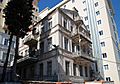
An old building in Artvin city center.
-
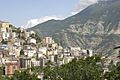
Artvin general view.
-
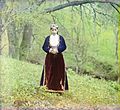
An Armenian woman in traditional clothes near Artvin, around 1910.
-
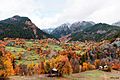
Çağliyan, a village in Şavşat.
-
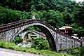
The Double Bridge in Artvin Province.


.jpg)


See Also
 In Spanish: Artvin para niños
