Ashland, Ohio facts for kids
Quick facts for kids
Ashland, Ohio
|
|||||
|---|---|---|---|---|---|

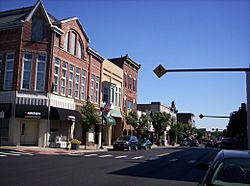
East Main Street, downtown
|
|||||
|
|||||
| Motto(s):
"Someplace Special"
|
|||||

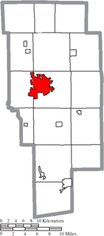
Location of Ashland in Ashland County
|
|||||
| Country | United States | ||||
| State | Ohio | ||||
| County | Ashland | ||||
| Area | |||||
| • Total | 11.35 sq mi (29.39 km2) | ||||
| • Land | 11.28 sq mi (29.22 km2) | ||||
| • Water | 0.06 sq mi (0.16 km2) | ||||
| Elevation | 1,066 ft (325 m) | ||||
| Population
(2020)
|
|||||
| • Total | 19,225 | ||||
| • Estimate
(2023)
|
18,718 | ||||
| • Density | 1,703.74/sq mi (657.84/km2) | ||||
| Time zone | UTC-5 (Eastern (EST)) | ||||
| • Summer (DST) | UTC-4 (EDT) | ||||
| ZIP code |
44805
|
||||
| Area codes | 419, 567 | ||||
| FIPS code | 39-02568 | ||||
| GNIS feature ID | 1085702 | ||||
Ashland is a city in Ashland County, Ohio, United States. It is the main city, or county seat, of Ashland County. The city is about 66 miles (106 km) southwest of Cleveland. In 2020, 19,225 people lived there. Ashland is the center of the Ashland Micropolitan statistical area, which includes all of Ashland County.
Contents
History of Ashland
Ashland was started in 1815 by William Montgomery. It was first called Uniontown. But in 1822, the city needed a new name because another town in Ohio was already named Uniontown.
How Ashland Got Its Name
The new name, Ashland, was chosen by people who supported Henry Clay. He was a famous politician from Kentucky. His home near Lexington was called Ashland. Later, people thought about naming the local high school "Henry Clay High School." Today, it is known as Ashland High School.
Early Growth and Industries
In the mid-1800s, some people from Ashland traveled to Oregon. They named a new settlement there after their hometown. In 1878, with help from the city, the German Baptist Brethren Church opened Ashland College.
Ashland quickly became an important place for making things in Ohio. In 1870, brothers Francis E. Myers and Philip A. Myers started a business. They sold farm equipment and fixed things. They created a special pump that gave a steady stream of water. By 1915, their company, F.E. Myers & Bro., had 800 workers. It was the biggest of 47 factories in Ashland at that time.
Other factories made different products. Reliable Match Co. made "Strike Anywhere Matches." Kauffman Mfg. Co. made folding chairs used by soldiers. Dr. Hess & Clark made supplies for animals and cleaners. T.W. Miller's Faultless Rubber Co. made rubber items, medical goods, and bicycle tires.
The Balloon Capital
In 1912, Harry Ross Gill, who was from Ashland, invented a way to make cigar-shaped balloons. Before this, balloons were only round. He started the Eagle Rubber Company in 1913. Later, he started the National Latex company in 1929. Because of Gill's work, Ashland became known as "the balloon capital of the world." The city still celebrates this history with its yearly BalloonFest.
In 1984, Ashland was named a Tree City USA by the National Arbor Day Foundation. This means the city cares about its trees and green spaces.
Geography of Ashland
Ashland covers about 11.23 square miles (29.09 km²) of land. Most of this area is land, with a small amount of water. The city has about 85.6 miles (137.8 km) of streets. It also has one hospital, two fire stations, one police station, and five parks for people to enjoy.
Population Information
Ashland has grown a lot over the years. Here's how its population has changed:
| Historical population | |||
|---|---|---|---|
| Census | Pop. | %± | |
| 1850 | 1,264 | — | |
| 1860 | 1,748 | 38.3% | |
| 1870 | 2,601 | 48.8% | |
| 1880 | 3,004 | 15.5% | |
| 1890 | 3,568 | 18.8% | |
| 1900 | 4,087 | 14.5% | |
| 1910 | 6,795 | 66.3% | |
| 1920 | 9,249 | 36.1% | |
| 1930 | 11,141 | 20.5% | |
| 1940 | 12,453 | 11.8% | |
| 1950 | 14,287 | 14.7% | |
| 1960 | 17,419 | 21.9% | |
| 1970 | 19,872 | 14.1% | |
| 1980 | 20,252 | 1.9% | |
| 1990 | 20,079 | −0.9% | |
| 2000 | 21,249 | 5.8% | |
| 2010 | 20,362 | −4.2% | |
| 2020 | 19,225 | −5.6% | |
| 2023 (est.) | 18,718 | −8.1% | |
| U.S. Decennial Census | |||
Population in 2010
In 2010, Ashland had 20,362 people living in 8,063 homes. About 28% of these homes had children under 18. Most people (95.8%) were White. About 1.4% were African American, and 1.0% were Asian. The average age in the city was about 36 years old.
City Government
Ashland is led by a mayor and a five-person city council. The mayor's name is Matt Miller. The Chief of Police for Ashland City is David Lay. The Ashland County sheriff is Kurt J. Schneider.
Transportation
The Ashland County Airport is located about 3 miles (4.8 km) northeast of Ashland's main downtown area.
Education in Ashland
The Ashland City School District serves 3,192 students. It has three elementary schools, one middle school, and one high school. The superintendent is Steve Paramore. There are also private schools like Ashland Christian School, St. Edward Catholic School, and Ashland Montessori School.
Ashland is home to Ashland University and Ashland Theological Seminary. These schools were started by the Brethren Church, which is a Christian church. The church's main office is also in Ashland.
The city also has the Ashland Public Library. The library offers free computers, Wi-Fi, and meeting rooms. You can get a library card for free, and the library does not charge late fees anymore. The library also has two bookmobiles that bring books to the community.
Notable People from Ashland
Many interesting people have come from Ashland, Ohio. Here are a few:
- William B. Allison – A politician who served in the U.S. House of Representatives and U.S. Senate for Iowa.
- Ernest Cline – A writer and screenwriter.
- Frank John William Goldsmith – A survivor of the Titanic sinking.
- Fred Martinelli – A famous college football coach.
- John Roseboro – A professional baseball player in Major League Baseball.
- Edmund G. Ross – A U.S. Senator for Kansas.
- Robert C. Springer – An astronaut.
- Matt Underwood – A TV announcer for the Cleveland Guardians baseball team.
- Ron Zook – A college football head coach.
See also
 In Spanish: Ashland (Ohio) para niños
 | Kyle Baker |
 | Joseph Yoakum |
 | Laura Wheeler Waring |
 | Henry Ossawa Tanner |


