
Atherton Islands facts for kids

Atherton Islands
Location in Antarctica
Location in Antarctica
|
|
| Geography | |
|---|---|
| Location | Antarctica |
| Coordinates | 62°6′S 58°59′W / 62.100°S 58.983°W |
| Administration | |
| Administered under the Antarctic Treaty System | |
| Demographics | |
| Population | Uninhabited |
The Atherton Islands are two small islands located near King George Island in Antarctica. They are about 4 kilometres (2 nmi) west-northwest of Bell Point. These islands are part of the South Shetland Islands, a group of islands in the Southern Ocean. No people live on the Atherton Islands permanently.
Contents
How the Atherton Islands Were Discovered
The Atherton Islands were first mapped by a group called Discovery Investigations. This happened during their expeditions between 1934 and 1935. These investigations were scientific trips aimed at exploring the Antarctic region and its waters.
Naming the Atherton Islands
The islands were named after Noel Atherton. He was a cartographer, which is a person who creates maps. At the time, he worked for the British Admiralty's Hydrographic Office. This office is responsible for making detailed charts of the seas. Noel Atherton later became the chief Civil Hydrographic Officer from 1951 to 1962.
Images for kids
-
Williams Point, discovered on 19 February 1819
-
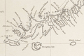
Fragment of George Powell's 1822 chart of the South Shetland Islands
-
Norwegian whaling boat, Half Moon Island
-
Ongal Peak, Tangra Mountains
-
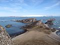
Renier Point
-
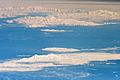
South Shetland Islands and Antarctic Peninsula. Astronaut photo, 2011
-
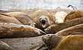
Elephant seals at Hannah Point
-
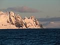
Devils Point, Livingston Island, with Morton Strait and Snow Island in the background, and Smith Island seen on the horizon on the right.
-
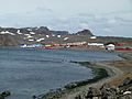
Chilean base Frei and Russian Bellingshausen (on the right)
-
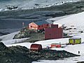
Bulgarian base Ohridski
-
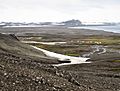
Camp Byers (International Field Camp)
-
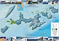
Topographic map of Livingston, Greenwich, Robert, Snow and Smith Islands


%E2%80%93Southern_elephant_seal_(Mirounga_leonina)_01.jpg)


See also
 In Spanish: Islas Shetland del Sur para niños
